- Home
- :
- All Communities
- :
- Products
- :
- Geoprocessing
- :
- Geoprocessing Questions
- :
- Why is the output from the Project tool empty?
- Subscribe to RSS Feed
- Mark Topic as New
- Mark Topic as Read
- Float this Topic for Current User
- Bookmark
- Subscribe
- Mute
- Printer Friendly Page
Why is the output from the Project tool empty?
- Mark as New
- Bookmark
- Subscribe
- Mute
- Subscribe to RSS Feed
- Permalink
I'm fairly novice in the ArcMap space, and my resident expert is on vacation. So I turn to the community...
I want to spatially join two point layers and determine the distance from one to the closest point in the other. This is fairly simple, except this time I'm dealing with two different projections / coordinate systems. When I join A to B, I'm getting a distance in what I believe is some form of decimal degree. Whatever it is, it's intelligible. If I were to join in the other direction, I'd get a distance in metres (desired), but I don't want to join that way as the feature counts between the two layers are not one to one.
So, I tried going to the toolbox and using the Data Management Tools -> Projections and Transformations -> Project tool to convert the one layer to the desired coordinate system. I drag/drop the Input Dataset, set the Output Dataset (new feature class), select the Output Coordinate System, leave the default transformation, and hit ok. It crunches for a bit then gives me the green checkbox. I open the newly created feature class to find it empty. <- I'm stumped.
Input Coordinate System: GCS_WGS_1984
Output Coordinate System: NAD_1983_UTM_Zone_14N
Geographic Transformation: WGS_1984_(ITRF00)_To_NAD_1983 <-- default selection
Anybody have any thoughts/suggestions?
Thank you much!
Solved! Go to Solution.
Accepted Solutions
- Mark as New
- Bookmark
- Subscribe
- Mute
- Subscribe to RSS Feed
- Permalink
Jake: Your work around set me onto my issue. While attempting to execute your work around, I realized that my input dataset was still a table and not a feature class. After having exported it to a feature class and starting over, everything functioned as desired.
Thank you for your help! (Thank you Dan for your response too.)
Cheers!
- Mark as New
- Bookmark
- Subscribe
- Mute
- Subscribe to RSS Feed
- Permalink
Hi Sean,
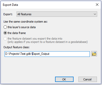
Not really sure why the output is empty, but here is a workaround you can try to keep moving forward:
1. Add the feature class you would like to project to ArcMap
2. Set the Data Frame's Coordinate System to NAD_1983_UTM_Zone_14N, and specify the appropriate Transformation
3. Right-click on the feature class you added in step 1 > Data > Export Data
4. Choose 'the data frame' under Use the same coordinate system as and then specify your output feature class:
- Mark as New
- Bookmark
- Subscribe
- Mute
- Subscribe to RSS Feed
- Permalink
drag and drop... try not to ... Try actually selecting the layer (ensuring that there are no selections on the data) manually within the dialog... I have seen the drag and drop not work in other environments. But Jake's suggestion is the quickest
- Mark as New
- Bookmark
- Subscribe
- Mute
- Subscribe to RSS Feed
- Permalink
Jake: Your work around set me onto my issue. While attempting to execute your work around, I realized that my input dataset was still a table and not a feature class. After having exported it to a feature class and starting over, everything functioned as desired.
Thank you for your help! (Thank you Dan for your response too.)
Cheers!