- Home
- :
- All Communities
- :
- Products
- :
- Geoprocessing
- :
- Geoprocessing Questions
- :
- Re: Line moving when clipped (projection help?)
- Subscribe to RSS Feed
- Mark Topic as New
- Mark Topic as Read
- Float this Topic for Current User
- Bookmark
- Subscribe
- Mute
- Printer Friendly Page
Line moving when clipped (projection help?)
- Mark as New
- Bookmark
- Subscribe
- Mute
- Subscribe to RSS Feed
- Permalink
I think what I am seeing is an artifact of the projection; but, I would like to get input from someone more knowledgeable than myself...
I have a line in NAD83 that I am viewing in Alaska state plane zone 4. When I clip the line it "jumps" off the original line and moves to the south. There is a significant distance between vertexes (~15,000m) for the input line in this area.
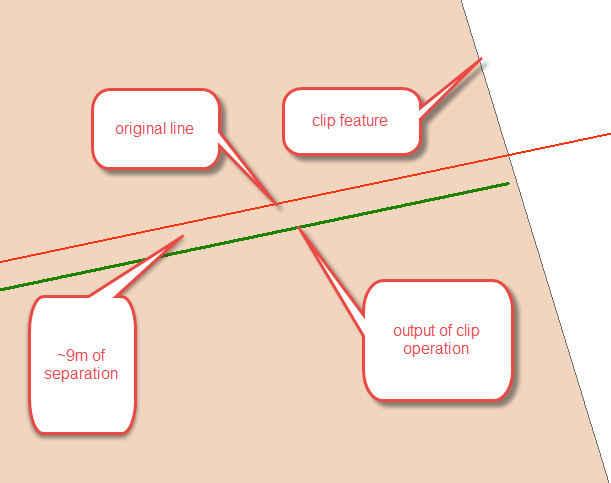
When things are viewed in NAD83 in arc everything lines up again.
Is this the expected behavior?
- Mark as New
- Bookmark
- Subscribe
- Mute
- Subscribe to RSS Feed
- Permalink
to confirm the projection thing... it is always an interesting check to densify the feature prior to clipping. I bet if you edited that line... added a vertex on the 'keeper' side of the line, it wouldn't jump much or at all. This phenom is more pronounced in the East West direction the further north you go (consider an unprojected and a projected map of areas north of 60 )
- Mark as New
- Bookmark
- Subscribe
- Mute
- Subscribe to RSS Feed
- Permalink
That worked Dan more or less.
Now, why is this occurring? I would think that when arc clips it would find the point on the geodesic line at the edge of the clip feature and use that...
- Mark as New
- Bookmark
- Subscribe
- Mute
- Subscribe to RSS Feed
- Permalink
Clip was written well before we had any geodesic line support. It would have to be upgraded WITH the ability for someone to decide whether to clip in projected space or treating lines as geodesics (or other types). I can think of cases where you wouldn't want the geodesic used (western north border of conus, projected data that represents plss or other surveyed lines, etc.).
- Mark as New
- Bookmark
- Subscribe
- Mute
- Subscribe to RSS Feed
- Permalink
Thanks Melita!
I have aircraft tracking data from a GPS system in WGS84. The aircraft only creates a sample point once every few minutes so it can cover a fair amount of ground in that time. The WGS84 is then changed to NAD83 (that is the preferred internal GCS in my organization). But when people map the data in Arc they will be using Alaska state plane zone 4, Alaska state plane zone 5, or Alaska Albers all on the NAD83 datum.
I am also doing a fair bit of geoprocessing on the data to understand how the flights interact with environmentally sensitive areas on the ground.
So, what would be the recommendation so that everything "lines" up more or less in the end? Would it be Dan's densify suggestion?
- Mark as New
- Bookmark
- Subscribe
- Mute
- Subscribe to RSS Feed
- Permalink
there is some stuff in arcpy that I haven't looked at much
PointGeometry—Help | ArcGIS Desktop
densify (type, distance, deviation)
Parameter Explanation Data Type
type
The type of densification, DISTANCE, ANGLE, or GEODESIC.
DISTANCE —Creates a new feature that is a piecewise linear approximation of the input.
ANGLE —Creates a new feature that is a piecewise linear approximation of the input. Vertices are introduced at points where the angle between tangents at those points is the provided angle.
GEODESIC —Densifies and reshapes segments between input vertices so that the output segments follow the shortest ground path connecting input vertices.
Would save you the project stuff, but I haven't tried it ... I am sure that there is something in arcpy enabling you to place a point along the geodesic and use it for the clip. Worth a look if you want to mess around with python and arcpy