Turn on suggestions
Auto-suggest helps you quickly narrow down your search results by suggesting possible matches as you type.
Cancel
- Home
- :
- All Communities
- :
- Products
- :
- Geoprocessing
- :
- Geoprocessing Questions
- :
- Calculating partial population of census tracts wi...
Options
- Subscribe to RSS Feed
- Mark Topic as New
- Mark Topic as Read
- Float this Topic for Current User
- Bookmark
- Subscribe
- Mute
- Printer Friendly Page
Calculating partial population of census tracts within buffers
Subscribe
5150
3
07-13-2012 11:02 AM
07-13-2012
11:02 AM
- Mark as New
- Bookmark
- Subscribe
- Mute
- Subscribe to RSS Feed
- Permalink
Hello,
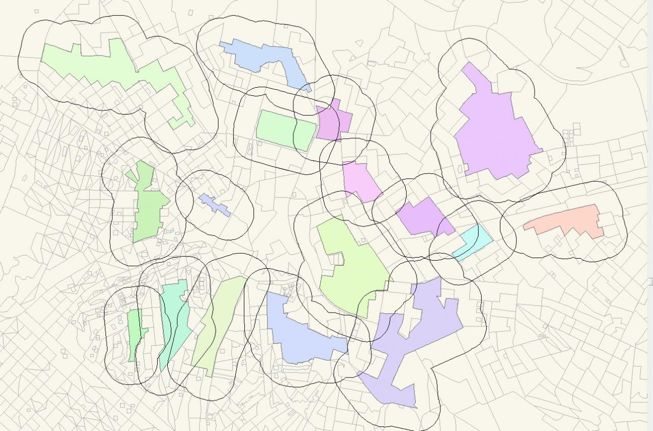
I am fairly new to GIS and I am trying to find out how many people fall into a neighborhoods (area of impact) for nurseries.
The neighborhoods are irregular shape file and I did 300 m buffers around 17 different sectors.
The 300 m buffers from all the 17 sectors at times overlap often two and three overlap and sometimes 4 sectors overlap.
Below the above two layers are census tracts with number of population field.
My question is what is the best way to calculate how many people will fall under each buffers for each sectors.
I presently lack the knowledge of using Phyton.
Thank you!
[ATTACH=CONFIG]16086[/ATTACH]
3 Replies
07-13-2012
01:01 PM
- Mark as New
- Bookmark
- Subscribe
- Mute
- Subscribe to RSS Feed
- Permalink
Please help anyone!
07-13-2012
01:11 PM
- Mark as New
- Bookmark
- Subscribe
- Mute
- Subscribe to RSS Feed
- Permalink
You'll want to clip the census tracts boundaries by the buffers layer, then run a dissolve on each group and use the statistics fields section to get the sum of the population fields. I think you'd want to use the Iterate Feature Selection iterator throughout the process to make sure you run each process, (clip, dissolve, etc) separately on each buffer boundary, since they overlap.
07-13-2012
01:32 PM
- Mark as New
- Bookmark
- Subscribe
- Mute
- Subscribe to RSS Feed
- Permalink
You'll want to clip the census tracts boundaries by the buffers layer, then run a dissolve on each group and use the statistics fields section to get the sum of the population fields. I think you'd want to use the Iterate Feature Selection iterator throughout the process to make sure you run each process, (clip, dissolve, etc) separately on each buffer boundary, since they overlap.
Thank you so much for your reply.
I have a question about your solution.
I just realized clipping could keep the proportions of original attributes in the new output! Thank you!
I am uncertain on how to perform Iterate feature... Would I also be able to take into consideration of the overlapped parts? I do not want to count them three times for instance. I want to only count them once and perhaps divide them into three (if there are three overlapping)..
Best,
C