Turn on suggestions
Auto-suggest helps you quickly narrow down your search results by suggesting possible matches as you type.
Cancel
- Home
- :
- All Communities
- :
- User Groups
- :
- GeoGeeks
- :
- Questions
- :
- in arcgis javascript api how to check whether give...
Options
- Subscribe to RSS Feed
- Mark Topic as New
- Mark Topic as Read
- Float this Topic for Current User
- Bookmark
- Subscribe
- Mute
- Printer Friendly Page
in arcgis javascript api how to check whether given xy coordinated lies inside a imported web map (imported from arcgis online)? i know that there is a method in polygons to check point lies inside a polygon. but how to convert a web map to a polygon????
Subscribe
1691
1
03-31-2018 09:09 PM
03-31-2018
09:09 PM
- Mark as New
- Bookmark
- Subscribe
- Mute
- Subscribe to RSS Feed
- Permalink
in arcgis javascript api how to check whether given xy coordinated lies inside a imported web map (imported from arcgis online)? i know that there is a method in polygons to check point lies inside a polygon. but how to convert a web map to a polygon????
1 Reply
04-01-2018
09:40 AM
- Mark as New
- Bookmark
- Subscribe
- Mute
- Subscribe to RSS Feed
- Permalink
Your webmap | ArcGIS for Developers will have a property called extent | ArcGIS for Developers that will provide the default extent:
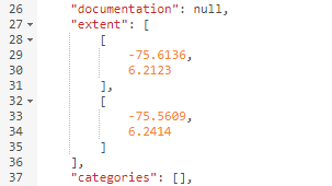
You can use the coordinates to create a polygon: Geometry objects—Common Data Types | ArcGIS for Developers and do your validation.
https://developers.arcgis.com/web-map-specification/objects/webmap/