- Home
- :
- All Communities
- :
- Products
- :
- Data Management
- :
- Geodatabase Questions
- :
- How to use GEOGRAPHY or GEOMETRY function in a SQL...
- Subscribe to RSS Feed
- Mark Topic as New
- Mark Topic as Read
- Float this Topic for Current User
- Bookmark
- Subscribe
- Mute
- Printer Friendly Page
How to use GEOGRAPHY or GEOMETRY function in a SQL for Register as Geodatabase tool
- Mark as New
- Bookmark
- Subscribe
- Mute
- Subscribe to RSS Feed
- Permalink
Hi Esri Community,
Does anybody recommend how to convert latitude and longitude columns using the GEOGRAPHY and GEOMETRY functions in a SQL view, which will source a Registered Feature Class within an Enterprise Geodatabase?
Here is my workflow:
1. Create SQL view in SSMS in SQL Server 2019 database. Tables are in another SQL Server 2019 database.
2. In ArcGIS Pro 2.9.5, use Create Database View tool
3. Use Register with Geodatabase (Database Management) tool?
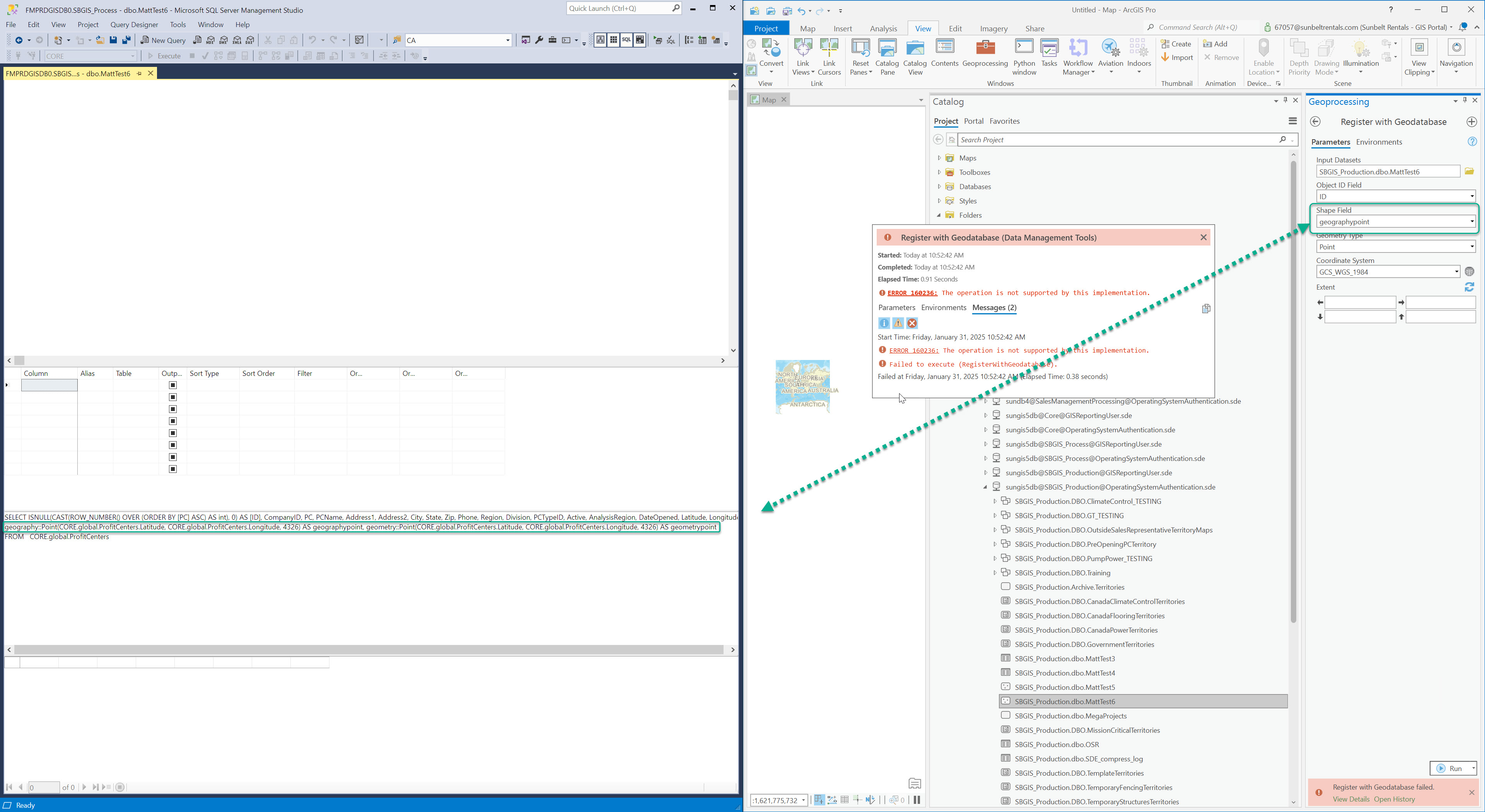
Unfortunately, I receive the error message: "ERROR 160236: The operation is not supported by this implementation."
My troubleshooting narrowed the issue down to the Shape Field paramter rin the Register with Geodatabase tool. This column is sourced from the geometry SQL function., which was created in the SQL VIEW. tried 2 SQL function:
- geography::Point(CORE.global.ProfitCenters.Latitude, CORE.global.ProfitCenters.Longitude, 4326) AS geographypoint, geometry::Point(CORE.global.ProfitCenters.Latitude, CORE.global.ProfitCenters.Longitude, 4326) AS geometrypoint
- geography::Point(CORE.global.ProfitCenters.Latitude, CORE.global.ProfitCenters.Longitude, 4326) AS geographypoint,
geometry::Point(CORE.global.ProfitCenters.Latitude, CORE.global.ProfitCenters.Longitude, 4326) AS geometrypoint
Solved! Go to Solution.
Accepted Solutions
- Mark as New
- Bookmark
- Subscribe
- Mute
- Subscribe to RSS Feed
- Permalink
If you change the "geometrypoint" field to "shape" then try to register, does that work?
**************************************************************************
Here is a query to take x/y in a table and create a shape field.
alter table [data].[CADRecordsData_Schema2] add shape as geometry::STGeomFromText('POINT('+convert(varchar(20),xCoord)+' '+convert(varchar(20),yCoord)+')',4326)
4326 = SRID
Added the spatial point shape column from the X/Y data in the table:
- Mark as New
- Bookmark
- Subscribe
- Mute
- Subscribe to RSS Feed
- Permalink
Hi George,
Thank you! I was able to register the following SQL view:
Here is what worked:
SELECT ISNULL(CAST(ROW_NUMBER() OVER (ORDER BY [Field1] ASC) AS int), 0) AS [ID], Field1, Latitude, Longitude,
geometry::STGeomFromText('POINT(' + CONVERT(varchar(20), CORE.global.Places.Longitude) + ' ' + CONVERT(varchar(20), CORE.global.Places.Latitude) + ')', 4326) AS Shape
FROM CORE.global.Places