- Home
- :
- All Communities
- :
- Products
- :
- Data Management
- :
- Geodatabase Questions
- :
- ArcSDE Feature class extent is in inconsistent spa...
- Subscribe to RSS Feed
- Mark Topic as New
- Mark Topic as Read
- Float this Topic for Current User
- Bookmark
- Subscribe
- Mute
- Printer Friendly Page
ArcSDE Feature class extent is in inconsistent spatial reference system.
- Mark as New
- Bookmark
- Subscribe
- Mute
- Subscribe to RSS Feed
- Permalink
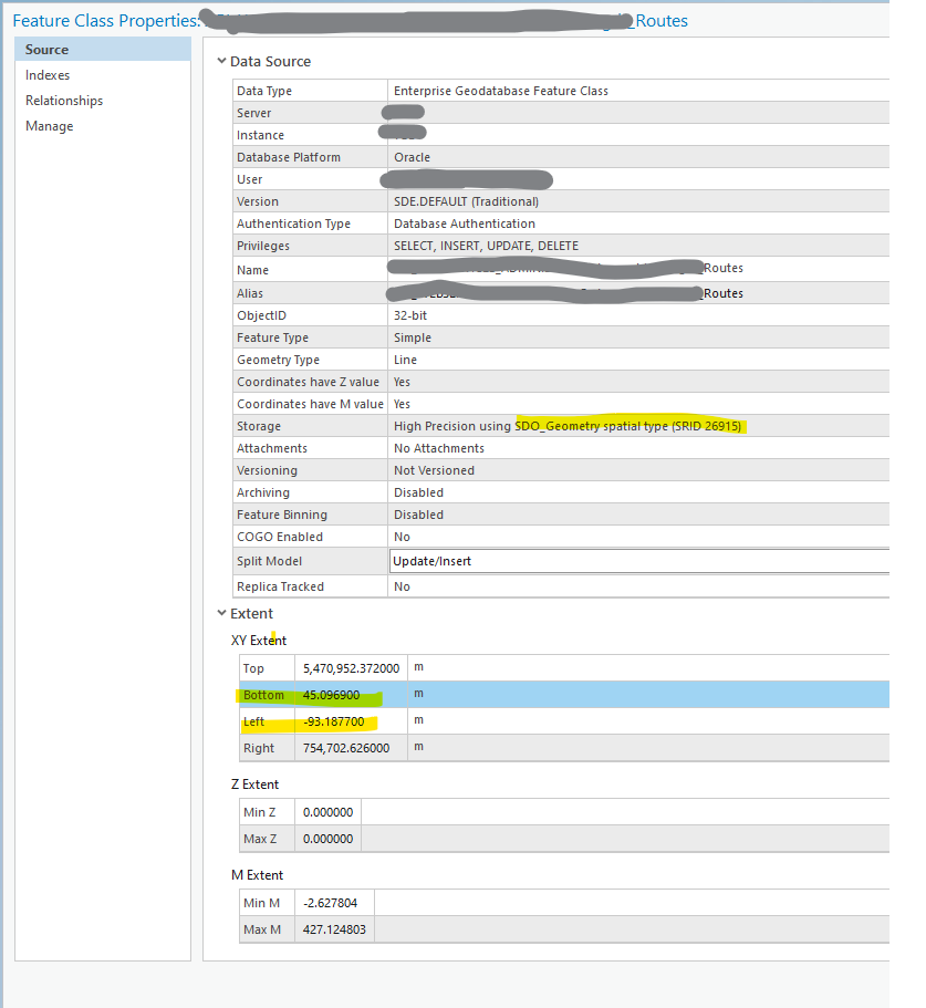
A feature class in our enterprise geodatabase seems to have an extent with inconsistent coordinates. See attached image. It appears that the lower left bounding coordinates are in unprojected/lat long coordinates when the feature class should be stored in 26915 NAD 83 15N. The upper right coordinates look appropriate.
What could cause this?
Solved! Go to Solution.
Accepted Solutions
- Mark as New
- Bookmark
- Subscribe
- Mute
- Subscribe to RSS Feed
- Permalink
Loading incorrectly projected data would certainly cause this, even if it was then deleted.
You should do a search for data in the range {-180,-90,+180,+90} to make sure improper data is not present, then you can reset the envelope of the dataset.
- V
- Mark as New
- Bookmark
- Subscribe
- Mute
- Subscribe to RSS Feed
- Permalink
NAILED IT! Thanks Vince. You have been helping me via these forums since like 2004!
Here is something that I am still hung up on..... maybe you could comment.
Why do the records below show up in the right spot on the map? Every thing appears to be in SRID 26915 so those very lat/long coordinates shouldn’t work right?….
OBJECTID
----------
SHAPE
--------------------------------------------------------------------------------
132150
SDO_GEOMETRY(4402,26915,NULL,MDSYS.SDO_ELEM_INFO_ARRAY(1,2,1,NULL,NULL,NULL,NULL
,NULL,NULL,NULL,NULL,NULL,NULL,NULL,NULL,NULL,NULL,NULL,NULL,NULL,NULL,NULL,NULL
,NULL,NULL,NULL,NULL,NULL,NULL,NULL,NULL,NULL,NULL,NULL,NULL,NULL,NULL,NULL,NULL
,NULL,NULL,NULL,NULL,NULL,NULL,NULL,NULL,NULL,NULL,NULL,NULL,NULL,NULL,NULL,NULL
,NULL,NULL,NULL,NULL,NULL,NULL,NULL,NULL,NULL,NULL,NULL,NULL,NULL,NULL,NULL,NULL
,NULL,NULL,NULL,NULL,NULL,NULL,NULL,NULL,NULL,NULL,NULL,NULL,NULL,NULL,NULL,NULL
,NULL,NULL,NULL,NULL,NULL,NULL,NULL,NULL,NULL,NULL,NULL,NULL,NULL),MDSYS.SDO_ORD
INATE_ARRAY(-93.1870999997482,45.0968999993056,0,-2.73430487141013E-8,-93.187699
9996603,45.1002999991179,0,2.20959191210568E-6,-93.1875,45.1052999999374,0,5.378
57704330236E-6,-93.1858000000939,45.1081000007689,0,7.49122409615666E-6,NULL,NUL
L,NULL,NULL,NULL,NULL,NULL,NULL,NULL,NULL,NULL,NULL,NULL,NULL,NULL,NULL,NULL,NUL
L,NULL,NULL,NULL,NULL,NULL,NULL,NULL,NULL,NULL,NULL,NULL,NULL,NULL,NULL,NULL,NUL
L,NULL,NULL,NULL,NULL,NULL,NULL,NULL,NULL,NULL,NULL,NULL,NULL,NULL,NULL,NULL,NUL
L,NULL,NULL,NULL,NULL,NULL,NULL,NULL,NULL,NULL,NULL,NULL,NULL,NULL,NULL,NULL,NUL
L,NULL,NULL,NULL,NULL,NULL,NULL,NULL,NULL,NULL,NULL,NULL,NULL,NULL,NULL,NULL,NUL
L,NULL,NULL))
132151
OBJECTID
----------
SHAPE
--------------------------------------------------------------------------------
SDO_GEOMETRY(4402,26915,NULL,MDSYS.SDO_ELEM_INFO_ARRAY(1,2,1,NULL,NULL,NULL,NULL
,NULL,NULL,NULL,NULL,NULL,NULL,NULL,NULL,NULL,NULL,NULL,NULL,NULL,NULL,NULL,NULL
,NULL,NULL,NULL,NULL,NULL,NULL,NULL,NULL,NULL,NULL,NULL,NULL,NULL,NULL,NULL,NULL
,NULL,NULL,NULL,NULL,NULL,NULL,NULL,NULL,NULL,NULL,NULL,NULL,NULL,NULL,NULL,NULL
,NULL,NULL,NULL,NULL,NULL,NULL,NULL,NULL,NULL,NULL,NULL,NULL,NULL,NULL,NULL,NULL
,NULL,NULL,NULL,NULL,NULL,NULL,NULL,NULL,NULL,NULL,NULL,NULL,NULL,NULL,NULL,NULL
,NULL,NULL,NULL,NULL,NULL,NULL,NULL,NULL,NULL,NULL,NULL,NULL,NULL),MDSYS.SDO_ORD
INATE_ARRAY(-93.1870999997482,45.0968999993056,0,-2.73430487141013E-8,-93.187699
9996603,45.1002999991179,0,2.20959191210568E-6,-93.1875,45.1052999999374,0,5.378
57704330236E-6,-93.1858000000939,45.1081000007689,0,7.49122409615666E-6,NULL,NUL
L,NULL,NULL,NULL,NULL,NULL,NULL,NULL,NULL,NULL,NULL,NULL,NULL,NULL,NULL,NULL,NUL
L,NULL,NULL,NULL,NULL,NULL,NULL,NULL,NULL,NULL,NULL,NULL,NULL,NULL,NULL,NULL,NUL
L,NULL,NULL,NULL,NULL,NULL,NULL,NULL,NULL,NULL,NULL,NULL,NULL,NULL,NULL,NULL,NUL
L,NULL,NULL,NULL,NULL,NULL,NULL,NULL,NULL,NULL,NULL,NULL,NULL,NULL,NULL,NULL,NUL
L,NULL,NULL,NULL,NULL,NULL,NULL,NULL,NULL,NULL,NULL,NULL,NULL,NULL,NULL,NULL,NUL
L,NULL,NULL))
2 rows selected.
- Mark as New
- Bookmark
- Subscribe
- Mute
- Subscribe to RSS Feed
- Permalink
If CAD objects are involved, Pro will render the CAD objects, not the geometry out of the database. It would be quite odd to get there, but that's the only reason that makes sense.
- V
- Mark as New
- Bookmark
- Subscribe
- Mute
- Subscribe to RSS Feed
- Permalink
Can you query the rows in a DA SearchCursor and output the Geometry.WKT for each? Does that display the correct projected values?
I have no idea how the layer could project on the fly to correct units if it didn't have correct SRID metadata.
- V
- Mark as New
- Bookmark
- Subscribe
- Mute
- Subscribe to RSS Feed
- Permalink
Now I see that I mistakenly thought that they show up in the correct location. Some of the bad records are technically multipart features where one part is correct. This confused me in ArcPro.
Not sure how these were created but at some point someone created the records in the correct location only with the lat/long coordinates. Then later they appear to have tried to correct them but instead created multipart features where the first part has the erroneous lat/long and the second part has correct utm coordinates. They are all overlapping.
For example:
SHAPE
--------------------------------------------------------------------------------
SDO_GEOMETRY(4406,26915,NULL,MDSYS.SDO_ELEM_INFO_ARRAY(1,2,1,17,2,1,NULL,NULL,NU
LL,NULL,NULL,NULL,NULL,NULL,NULL,NULL,NULL,NULL,NULL,NULL,NULL,NULL,NULL,NULL,NU
LL,NULL,NULL,NULL,NULL,NULL,NULL,NULL,NULL,NULL,NULL,NULL,NULL,NULL,NULL,NULL,NU
LL,NULL,NULL,NULL,NULL,NULL,NULL,NULL,NULL,NULL,NULL,NULL,NULL,NULL,NULL,NULL,NU
LL,NULL,NULL,NULL,NULL,NULL,NULL,NULL,NULL,NULL,NULL,NULL,NULL,NULL,NULL,NULL,NU
LL,NULL,NULL,NULL,NULL,NULL,NULL,NULL,NULL,NULL,NULL,NULL,NULL,NULL,NULL,NULL,NU
LL,NULL,NULL,NULL,NULL,NULL,NULL,NULL,NULL,NULL,NULL,NULL),MDSYS.SDO_ORDINATE_AR
RAY(-93.1870999997482,45.0968999993056,0,NULL,-93.1876999996603,45.1002999991179
,0,NULL,-93.1875,45.1052999999374,0,NULL,-93.1858000000939,45.1081000007689,0,NU
LL,485335.1694,4993557.3813,0,NULL,485333.3085,4993569.3357,0,NULL,485334.5785,4
993578.0669,0,NULL,485336.9598,4993586.4807,0,NULL,485338.8648,4993597.9107,0,NU
LL,485341.0873,4993608.7058,0,NULL,485342.6748,4993619.6595,0,NULL,485343.3098,4
993632.3596,0,NULL,485341.4048,4993645.0596,0,NULL,485338.5473,4993657.2834,0,NU
LL,485334.1023,4993670.4596,0,NULL,485329.3398,4993681.0959,0,NULL,485320.1323,4
993694.5897,0,NULL,485312.036,4993704.2734,0,NULL,485304.0985,4993713.1635,0,NUL
L,485293.9385,4993725.546,0,NULL,485287.5884,4993731.896,0,NULL,485280.0566,4993
734.851,0,NULL,NULL,NULL,NULL,NULL,NULL,NULL,NULL,NULL,NULL,NULL,NULL,NULL))
- Mark as New
- Bookmark
- Subscribe
- Mute
- Subscribe to RSS Feed
- Permalink
That makes more sense. You should be able to use SQL to update the lat/lon geometry component, if you just isolate the lat/lon coords and project them.
- V