- Home
- :
- All Communities
- :
- Networks
- :
- Esri Young Professionals Network
- :
- Esri YPN Blog
- :
- GIS Career Pathways: Esri Solution Engineer
GIS Career Pathways: Esri Solution Engineer
- Subscribe to RSS Feed
- Mark as New
- Mark as Read
- Bookmark
- Subscribe
- Printer Friendly Page
Hello Esri YPN community!
I'm excited to share my journey and insights into the world of GIS with you. My name is Sarah Zimmer, and I currently work as a Solution Engineer at Esri, on the AEC (Architecture, Engineering, Environmental, and Construction) industry team. My path to this role has been filled with learning, growth, and a deep passion for environmental science and geographic information systems (GIS).
Discovering a Passion for Geography
Originally from Wisconsin, my love for the environment was nurtured by my parents, who instilled in me the importance of taking care of our planet, not only for those around us, but for other generations to enjoy as well. This early indoctrination led me to pursue a degree in Geography with a focus on Environmental Science from the University of Colorado in Denver. In order to be more competitive on the job market, I also completed a GIS certificate. During my junior and senior year of college, I found myself spending a few months studying abroad in Chile and Costa Rica, further broadening my understanding of environmental science and GIS. In this way, I learned how to collect geospatial data in the field by flying drones, collecting GPS points and utilizing surveying techniques for a more location-based analysis. Both trips changed my previously held perspective that GIS was “just another class”. I found that my journey into this industry was not only inspired by my initial desire to make a positive impact on the environment, but to do so through the use of technology combined with a systems-based management approach.
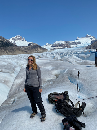
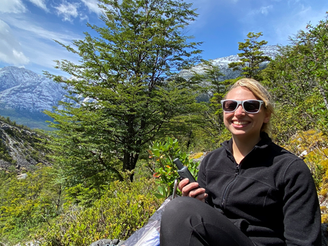
Semester abroad in Patagonia, Chile
Collecting location data in the field using GPS
GIS Internships
My geospatial journey began with an internship at the State of Colorado’s Department of Natural Resources, which provided me with invaluable hands-on experience. In my role with the DNR, I was given the task of building the state of Colorado’s Low Head Dam database, where I used critical thinking, round table discussion with stakeholders, and the geospatial approach to categorize various dams for level of risk to recreationalists and emergency personnel. In total, I was able to georeference 1,100 dams across Colorado using satellite imagery and historical water rights records.
Through this experience, I developed a deep respect and passion for the power of GIS. While it is an amazing and powerful tool, it is up to us as GIS analysts and scientists to accurately identify areas where it can make the most impact for the greatest amount of good… in this case, alerting the public of the locations of potentially dangerous hydraulic structures. In addition to the database itself, I created a public facing ArcGIS Survey123 form where the public could submit dams they encountered that may have been missed in the initial database creation phase. By empowering those around us with geospatial tools, even without formal training, we are able to create data that allows for more informed decision making in a collaborative and transparent environment.
Launching My GIS Career
My first job upon graduation was a continuation of my second college internship. A small water engineering firm based in several cities across the state, Wright Water Engineers was where I really launched my geospatial career. From assisting with water rights assessments and permitting applications for various AEC clients, to attending conferences and weekly field work assignments, my experiences were varied and interesting. It didn’t take long for me to determine that AEC was where I wanted to be. After several more years working as a GIS analyst at a construction company and an imagery analyst at MAXAR, I found myself in a role at a campground development company called Ramble Outdoors. After a year of traveling around the US looking at potential campground locations and modeling suitability, I found myself interviewing and securing a role on the AEC Solution Engineer team at Esri.
Collecting water samples.
While switching from a GIS analyst role in water engineering, to analyzing satellite imagery, then working in an outdoor hospitality role at a campground development company and then switching back to a broader AEC industry focused role might seem outwardly daunting, it surprisingly was not too difficult. This is in part due to the core function between all of my previous roles, which was utilizing ArcGIS applications to perform various workflows. At their core, all of my day-to-day tasks were intended to utilize location intelligence for more informed decision making. It helped tremendously that I could apply my systems-based understanding of environmental management practices to any and every setting.
Being a Solution Engineer at Esri
At Esri, I am part of a dynamic team that leverages GIS to support various industries. On a daily basis, my role involves demonstrating the "art of the possible" through virtual and in-person engagements, workflow demonstrations, and troubleshooting with customers. I enjoy networking across the company and with our partner organizations, building what we call our "Team of Teams." This collaborative approach allows us to provide comprehensive solutions to our customers' challenges.
To be successful in the role of an AEC Solution Engineer at Esri, you will need a combination of hard and soft skills. As a GIS subject matter expert, proficiency in Esri technology is essential, including creating maps, performing spatial analysis, and configuring web applications. Additionally, having at least one year of experience in the Architecture, Engineering, and Construction (AEC) industry is crucial. Technical consulting experience and conceptual solution design skills are also important, as well as a solid understanding of ArcGIS from an IT context, including hardware, storage, security, networking, web services, virtualization, and cloud computing (Microsoft Azure or AWS). Familiarity with geodatabases and underlying DBMS technology, knowledge of cloud computing concepts and environments, and experience with programming and scripting languages such as Python and JavaScript will further enhance your capabilities.
In addition to these hard skills, several soft skills are vital for success in this role. Remarkable presentation skills are needed to confidently speak with customers about Esri technologies and communicate the Esri message effectively. Strong interpersonal skills are essential for building relationships and supporting your team in planning and executing sales strategies. Excellent listening skills will help you understand customer needs and anticipate technological trends that may impact them. Proactive problem-solving skills are crucial for crafting and proposing solutions that clarify how GIS brings business value to customers. The ability to tell compelling stories through technical demonstrations and presentations to both technical and non-technical customers is also important.
These skills will help you effectively communicate the value of GIS technology, build strong relationships with customers, and provide innovative solutions to complex business challenges.
Additional Tips for Geospatial Success
While starting a career in GIS can be incredibly rewarding, there are several key tips to ensure success in this field for those just starting out. Embracing continuous learning is crucial, as staying updated with the latest GIS trends and technologies can significantly enhance your skills. Online courses and certifications from platforms like LinkedIn Learning, Coursera, Udemy, and Esri Training are highly recommended. Building strong networks is also essential; attending industry conferences such as the Esri User Conference, workshops, and events can help you connect with professionals and discover job opportunities. Groups like GIS Colorado, Rocky Mountain PUG, Rocky Mountain GPN, and Women in GIS are excellent for networking and skill development. Effective communication skills are vital for GIS projects, as clear reporting and professionalism can build trust and lead to successful collaborations. Maintaining a portfolio of your geospatial projects can further demonstrate your value to potential employers. Mastering time management is important for balancing multiple projects and deadlines, and tools like digital business cards and clear meeting agendas can help you stay organized. Fostering collaboration by working well with peers and teams, delegating tasks, and maintaining good relationships is key for future references and recommendations. Lastly, cultivating adaptability is important in the ever-evolving GIS field; embracing changes and challenges, knowing your strengths and weaknesses, and planning your schedule effectively will help you manage your time and priorities efficiently.
If you have any questions or would like to learn more about a career in GIS or more specifically, a career at Esri as a Solution Engineer, feel free to reach out to me on LinkedIn or via email. Lastly, be sure to check out my portfolio of professional works.
Thank you for reading, and I look forward to connecting with you!
You must be a registered user to add a comment. If you've already registered, sign in. Otherwise, register and sign in.


