- Home
- :
- All Communities
- :
- Services
- :
- Esri Training
- :
- Esri Training Questions
- :
- Converted RasterToPoints were not positioned at th...
- Subscribe to RSS Feed
- Mark Topic as New
- Mark Topic as Read
- Float this Topic for Current User
- Bookmark
- Subscribe
- Mute
- Printer Friendly Page
Converted RasterToPoints were not positioned at the centers of cells
- Mark as New
- Bookmark
- Subscribe
- Mute
- Subscribe to RSS Feed
- Permalink
- Report Inappropriate Content
Dear all,
I am very new beginner of ArcGIS and using ArcMap for Destop 10.4.1 to convert raster tif file to shapefile (points).
The problem I had is the converted points were not positioned at the centers of cells that they represent as can be seen in the attached picture. Please help me solve the problem.
Thank you in advance.
- Mark as New
- Bookmark
- Subscribe
- Mute
- Subscribe to RSS Feed
- Permalink
- Report Inappropriate Content
- What version of ArcGIS are you using?
- What is the coordinate system of;
- input raster
- output points
- have you set any environments?
-Steve
- Mark as New
- Bookmark
- Subscribe
- Mute
- Subscribe to RSS Feed
- Permalink
- Report Inappropriate Content
Dear Steve
Thank you for your e-mail. My reply to your your questions as below.
1) ArcGIS 10.4.1 for Desktop
2.1) Input raster was NDVI TIF file obtained by remote sensing technique.
The coordinate system is ENU.
2.2) For output points, I used ArcMap Tool to convert raster to point,
so I do not know which coordinate system of the output points.
3) No environment was set
I am looking forward to your further advice.
Nang
- Mark as New
- Bookmark
- Subscribe
- Mute
- Subscribe to RSS Feed
- Permalink
- Report Inappropriate Content
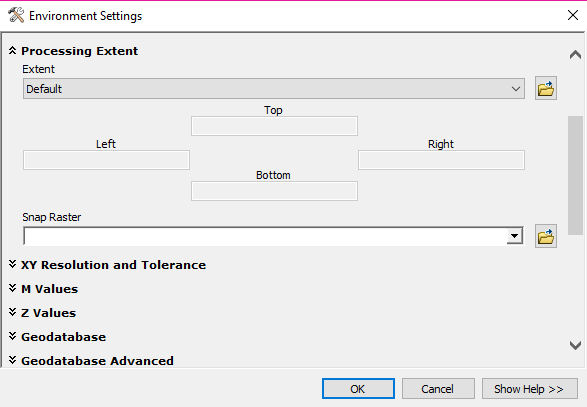
Hi Nang, see this help topic for information on the tool behavior. One possibility is that the tool's Processing Extent environment setting can cause the points to shift off-center. Setting the Snap Raster to your input raster file may fix the issue. http://desktop.arcgis.com/en/arcmap/latest/tools/conversion-toolbox/raster-to-point.htm
- Mark as New
- Bookmark
- Subscribe
- Mute
- Subscribe to RSS Feed
- Permalink
- Report Inappropriate Content
Dear Suzanne,
Thank you so much. I will try raster_to_point again following your instruction.