- Home
- :
- All Communities
- :
- Global
- :
- Asia Pacific
- :
- Esri India
- :
- Esri India Questions
- :
- Why flow direction tool shows Hooghly River as flo...
- Subscribe to RSS Feed
- Mark Topic as New
- Mark Topic as Read
- Float this Topic for Current User
- Bookmark
- Subscribe
- Mute
- Printer Friendly Page
Why flow direction tool shows Hooghly River as flowing north?
- Mark as New
- Bookmark
- Subscribe
- Mute
- Subscribe to RSS Feed
- Permalink
Hello,
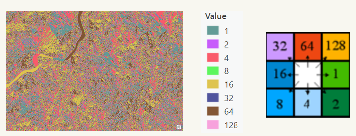
I am using the Hydrology tools in ArcGIS Pro to delineate urban watersheds in Kolkata. I have noticed that when I use the Flow Direction tool, some of the values of the Hooghly River (alternatively spelled Hoogli or Hugli) are coded to point north (value of 64). The river winds it way southward until it reaches the Bay of Bengal, however, so the map is not accurate. I have attached an image to show these results.

I am using 30-m resolution because I am unable to purchase higher resolution data at this time. This may be the reason for the inaccurate results.
Is there a way to re-code this information so that the flow direction raster is accurate for the Hooghly River?
Thank you!
-Jamie
- Mark as New
- Bookmark
- Subscribe
- Mute
- Subscribe to RSS Feed
- Permalink
Jamie, did you use the "Fill" tool before using the "Flow Direction"?
- Mark as New
- Bookmark
- Subscribe
- Mute
- Subscribe to RSS Feed
- Permalink
Yes, I did.
- Mark as New
- Bookmark
- Subscribe
- Mute
- Subscribe to RSS Feed
- Permalink
Is there a place where I can download the original 30m raster? I will have some time to test it out if you would like.
- Mark as New
- Bookmark
- Subscribe
- Mute
- Subscribe to RSS Feed
- Permalink
I used EarthData to download the DEM. It requires creating an account.
Thank you!
Jamie
- Mark as New
- Bookmark
- Subscribe
- Mute
- Subscribe to RSS Feed
- Permalink
Hello Matthew,
I hate to be a pest, but have you been able to test the original raster? I am very motivated to find out why the Flow Direction tool codes a portion of the river as running north and how I might be able to fix this. Your help would be greatly appreciated with this!
Many thanks,
Jamie
- Mark as New
- Bookmark
- Subscribe
- Mute
- Subscribe to RSS Feed
- Permalink
Sorry I had to get IT to bypass a firewall issue. I just tried it and got the same results as you.
I found a different DEM and it is having the same results.
- Mark as New
- Bookmark
- Subscribe
- Mute
- Subscribe to RSS Feed
- Permalink
Hi Matthew,
Thank you for running the analysis and getting back to me on this! Do you have any thoughts as to why this is happening? Is it just a result of using 30-m resolution data?
Do you know if there is a way to correct the coding?
Thank you,
Jamie