- Home
- :
- All Communities
- :
- Developers
- :
- Developers - General
- :
- Developers Questions
- :
- Why do dimensions disapear when close and open map...
- Subscribe to RSS Feed
- Mark Topic as New
- Mark Topic as Read
- Float this Topic for Current User
- Bookmark
- Subscribe
- Mute
- Printer Friendly Page
Why do dimensions disapear when close and open map.
- Mark as New
- Bookmark
- Subscribe
- Mute
- Subscribe to RSS Feed
- Permalink
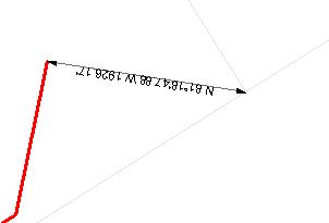
I create dimension feature class I change the style, add dimensions to my map but when I reopen the map the dimensions are gone? Is there documentation I can read about this behavior. I am also interested in creating dimensions with python code but I have found no examples.
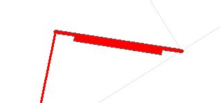
Update- I created a button that creates a dim with style inside a geodatabase, now when I close and open the map the dimensions are just red polygons.


after close and open arcmap before close and open
Here is the code I sued to create the dimension feature class.
IFeatureLayer pFeatureLayer = (IFeatureLayer)pBoundaryLayer;
IFeatureClass pFeatureClass = pFeatureLayer.FeatureClass;
string strCatalogPath = GetCatalogPath(pFeatureClass);
IWorkspace pWorkspace = FileGDBWorkspaceFromPropertySet(strCatalogPath);
IObjectClassDescription ocDescription = new DimensionClassDescription();
IFields pRequiredFields = ocDescription.RequiredFields;
int intShapeFieldPosition = pRequiredFields.FindField("Shape");
IField pShapeField = pRequiredFields.get_Field(intShapeFieldPosition);
IGeometryDef pGeomDef = pShapeField.GeometryDef;
IGeometryDefEdit pGeomDefEdit = (IGeometryDefEdit)pGeomDef;
ISpatialReferenceFactory3 pSpatRefFac = new SpatialReferenceEnvironmentClass();
ISpatialReference pSpatRef = pSpatRefFac.CreateSpatialReference(6578);
IProjectedCoordinateSystem pProSpatRef = (IProjectedCoordinateSystem)pSpatRef;
ILinearUnit linUnit = pProSpatRef.CoordinateUnit;
pGeomDefEdit.SpatialReference_2 = pSpatRef;
IFeatureWorkspace pFeatWorkspace = (IFeatureWorkspace)pWorkspace;
string pName = "DIM";
IFeatureClass pNewFeatureClass = pFeatWorkspace.CreateFeatureClass(pName.ToString(), pRequiredFields, ocDescription.InstanceCLSID, ocDescription.ClassExtensionCLSID, esriFeatureType.esriFTDimension, "Shape", "");
ISchemaLock schemaLock = (ISchemaLock)pNewFeatureClass;
try
{
schemaLock.ChangeSchemaLock(esriSchemaLock.esriExclusiveSchemaLock);
IDimensionClassExtension dimExtension = (IDimensionClassExtension)pNewFeatureClass.Extension;
dimExtension.ReferenceScale = 12000;
dimExtension.ReferenceScaleUnits = esriUnits.esriFeet;
IDimensionStyle dimensionStyle = new DimensionStyleClass();
dimensionStyle.Name = "BEARING_DISTANCE";
IDimensionStyleText dimText = (IDimensionStyleText)dimensionStyle;
string expression = "def FindLabel ( [DIMLENGTH], [BEGINX] , [BEGINY] , [ENDX] , [ENDY] ):" + Environment.NewLine +
" import math" + Environment.NewLine +
" dY = float([ENDY]) -float( [BEGINY])" + Environment.NewLine +
" dX = float( [ENDX])-float( [BEGINX])" + Environment.NewLine +
" azimuth = math.atan2(dX, dY) * 180 / math.pi" + Environment.NewLine +
" if azimuth < 0:" + Environment.NewLine +
" azimuth = azimuth + 360" + Environment.NewLine +
" if azimuth > 270 and azimuth<= 360:" + Environment.NewLine +
" bearing = 360 - azimuth" + Environment.NewLine +
" minutes,seconds = divmod(bearing * 3600, 60)" + Environment.NewLine +
" degrees,minutes = divmod(minutes, 60)" + Environment.NewLine +
" dmsBearing = \"N \" + str(int(degrees)) + \"°\" + str(int(minutes)) + \"'\" + str(round(seconds, 2)) + \" W\"" + Environment.NewLine +
" return dmsBearing + \" \" + str(round(float( [DIMLENGTH]), 2))+\"'\"" + Environment.NewLine +
" if azimuth > 180 and azimuth<= 270:" + Environment.NewLine +
" bearing = azimuth - 180" + Environment.NewLine +
" minutes,seconds = divmod(bearing * 3600, 60)"+ Environment.NewLine +
" degrees,minutes = divmod(minutes, 60)"+ Environment.NewLine +
" dmsBearing = \"S \" + str(int(degrees)) + \"°\" + str(int(minutes)) + \"'\" + str(round(seconds, 2)) + \" W\"" + Environment.NewLine +
" return dmsBearing + \" \" + str(round(float( [DIMLENGTH]), 2))+\"'\"" + Environment.NewLine +
" if azimuth > 90 and azimuth<= 180:" + Environment.NewLine +
" bearing = 180 - azimuth" + Environment.NewLine +
" minutes,seconds = divmod(bearing * 3600, 60)" + Environment.NewLine +
" degrees,minutes = divmod(minutes, 60)" + Environment.NewLine +
" dmsBearing = \"S \" + str(int(degrees)) + \"°\" + str(int(minutes)) + \"'\" + str(round(seconds, 2)) + \" E\"" + Environment.NewLine +
" return dmsBearing + \" \" + str(round(float( [DIMLENGTH]), 2))+\"'\"" + Environment.NewLine +
" if azimuth >= 0 and azimuth<= 90:" + Environment.NewLine +
" minutes,seconds = divmod(azimuth * 3600, 60)" + Environment.NewLine +
" degrees,minutes = divmod(minutes, 60)" + Environment.NewLine +
" dmsBearing = \"N \" + str(int(degrees)) + \"°\" + str(int(minutes)) + \"'\" + str(round(seconds, 2)) + \" E\"" + Environment.NewLine +
" return dmsBearing + \" \" + str(round(float( [DIMLENGTH]), 2))+\"'\"" + Environment.NewLine +
" else:" + Environment.NewLine +
" if azimuth > 270 and azimuth<= 360:" + Environment.NewLine +
" bearing = 360 - azimuth" + Environment.NewLine +
" minutes,seconds = divmod(bearing * 3600, 60)" + Environment.NewLine +
" degrees,minutes = divmod(minutes, 60)" + Environment.NewLine +
" dmsBearing = \"N \" + str(int(degrees)) + \"°\" + str(int(minutes)) + \"'\" + str(round(seconds, 2)) + \" W\"" + Environment.NewLine +
" return dmsBearing + \" \" + str(round(float( [DIMLENGTH]), 2))+\"'\"" + Environment.NewLine +
" if azimuth > 180 and azimuth<= 270:" + Environment.NewLine +
" bearing = azimuth - 180" + Environment.NewLine +
" minutes,seconds = divmod(bearing * 3600, 60)" + Environment.NewLine +
" degrees,minutes = divmod(minutes, 60)" + Environment.NewLine +
" dmsBearing = \"S \" + str(int(degrees)) + \"°\" + str(int(minutes)) + \"'\" + str(round(seconds, 2)) + \" W\"" + Environment.NewLine +
" return dmsBearing + \" \" + str(round(float( [DIMLENGTH]), 2))+\"'\"" + Environment.NewLine +
" if azimuth > 90 and azimuth<= 180:" + Environment.NewLine +
" bearing = 180 - azimuth" + Environment.NewLine +
" minutes,seconds = divmod(bearing * 3600, 60)" + Environment.NewLine +
" degrees,minutes = divmod(minutes, 60)" + Environment.NewLine +
" dmsBearing = \"S \" + str(int(degrees)) + \"°\" + str(int(minutes)) + \"'\" + str(round(seconds, 2)) + \" E\"" + Environment.NewLine +
" return dmsBearing + \" \" + str(round(float( [DIMLENGTH]), 2))+\"'\"" + Environment.NewLine +
" if azimuth >= 0 and azimuth<= 90:" + Environment.NewLine +
" minutes,seconds = divmod(azimuth * 3600, 60)" + Environment.NewLine +
" degrees,minutes = divmod(minutes, 60)" + Environment.NewLine +
" dmsBearing = \"N \" + str(int(degrees)) + \"°\" + str(int(minutes)) + \"'\" + str(round(seconds, 2)) + \" E\"" + Environment.NewLine +
" return dmsBearing + \" \" + str(round(float( [DIMLENGTH]), 2))+\"'\"";
dimText.Expression = expression;
dimText.ExpressionSimple = false;
dimText.ExpressionParserName = "Python";
dimText.TextDisplay = esriDimensionTextDisplay.esriDimensionTDExpression;
dimText.ExtendLineOnFit = false;
stdole.IFontDisp iFont = new stdole.StdFontClass() as stdole.IFontDisp;
iFont.Name = "Arial";
iFont.Size = 8;
ITextSymbol txtSymbol = new TextSymbol();
txtSymbol.Font = iFont;
dimText.TextSymbol = txtSymbol;
IDimensionStyleDisplay dimDisplay = (IDimensionStyleDisplay)dimensionStyle;
dimDisplay.MarkerDisplay = esriDimensionDisplay.esriDimensionDisplayBoth;
IArrowMarkerSymbol mrkrSym = new ArrowMarkerSymbolClass();
mrkrSym.Size = 6;
IMarkerSymbol newMrkrSym = (IMarkerSymbol)mrkrSym;
dimDisplay.BeginMarkerSymbol = newMrkrSym;
dimDisplay.EndMarkerSymbol = newMrkrSym;
dimDisplay.MarkerFit = esriDimensionMarkerFit.esriDimensionMarkerFitText;
IDimensionStyles dimensionStyles = dimExtension.DimensionStyles;
dimensionStyles.AddStyle(dimensionStyle);
}
catch(COMException comExcept)
{
MessageBox.Show(comExcept.StackTrace.ToString());
}
finally
{
schemaLock.ChangeSchemaLock(esriSchemaLock.esriSharedSchemaLock);
MessageBox.Show("The Dimension Feature Class Has Been Created");
}Is there something I can add to make this layer persist?
- Mark as New
- Bookmark
- Subscribe
- Mute
- Subscribe to RSS Feed
- Permalink
I implemented persistence on the Dimension Style and now the Dimensions show up when I open a map with dimensions,