- Home
- :
- All Communities
- :
- Developers
- :
- Developers - General
- :
- Developers Questions
- :
- maps for office
- Subscribe to RSS Feed
- Mark Topic as New
- Mark Topic as Read
- Float this Topic for Current User
- Bookmark
- Subscribe
- Mute
- Printer Friendly Page
- Mark as New
- Bookmark
- Subscribe
- Mute
- Subscribe to RSS Feed
- Permalink
Hi, I've been trying to create a layer out of an excel table with many different columns which two of them are coordinates with a different spatial reference then the default one. i'm using 2039. When the data is being added to the map, it shows up perfectly for a second and then disappears.. the map says all the point were marked as errors! any idea why is that??
Solved! Go to Solution.
Accepted Solutions
- Mark as New
- Bookmark
- Subscribe
- Mute
- Subscribe to RSS Feed
- Permalink
Sviva,
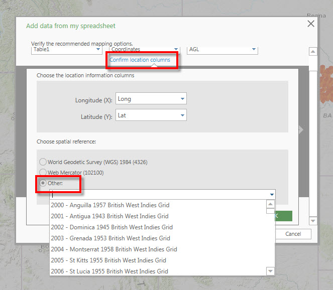
Have you selected the spatial reference in the Add data from my spreadsheet dialog to match your data?
- Mark as New
- Bookmark
- Subscribe
- Mute
- Subscribe to RSS Feed
- Permalink
Hi Sviva,
Would you be able to upload a sample of your excel spreadsheet?
- Mark as New
- Bookmark
- Subscribe
- Mute
- Subscribe to RSS Feed
- Permalink
Hi Jake, thanks for the quick reply.
I was just about to reply to you that I've tested it on a smaller sheet and it worked out fine and while going back to take a screen shot all points disappeared again and marked as errors! so weird.
I attached the excel and screenshot of the error
I suspect it might work at your side because of basemaps with a different spatial reference - in my case I can choose only my own basemaps which all have a unique spatial reference.. not web mercator that is
- Mark as New
- Bookmark
- Subscribe
- Mute
- Subscribe to RSS Feed
- Permalink
What is the coordinate system of your basemaps?
- Mark as New
- Bookmark
- Subscribe
- Mute
- Subscribe to RSS Feed
- Permalink
My basemap's spatial reference is 2039... What Kyle wrote fixed my problem  I didn't notice that option. thanks
- Mark as New
- Bookmark
- Subscribe
- Mute
- Subscribe to RSS Feed
- Permalink
Sviva,
Have you selected the spatial reference in the Add data from my spreadsheet dialog to match your data?
- Mark as New
- Bookmark
- Subscribe
- Mute
- Subscribe to RSS Feed
- Permalink
Thank you Kyle, I didn't even notice that option exists.. It solved my problem.
A bit irrelevant but any idea if all types of named users can have this plug-in for excel to use?
For ArcGIS Pro for example you need to be a named user with a desktop license.
- Mark as New
- Bookmark
- Subscribe
- Mute
- Subscribe to RSS Feed
- Permalink
Esri Maps for Office does require a named user on an ArcGIS Online for Organizations subscription. No desktop license required.
See the System Requirements section