- Home
- :
- All Communities
- :
- Products
- :
- Data Management
- :
- Data Management Questions
- :
- Re: XY Event Layer not lining up with Polygon Laye...
- Subscribe to RSS Feed
- Mark Topic as New
- Mark Topic as Read
- Float this Topic for Current User
- Bookmark
- Subscribe
- Mute
- Printer Friendly Page
XY Event Layer not lining up with Polygon Layer
- Mark as New
- Bookmark
- Subscribe
- Mute
- Subscribe to RSS Feed
- Permalink
I am using ArcMap 10.6.1. I am working in the North American 1983 Datum with the USA_Contiguous_Albers_Equal_Area_Conic projection. I cannot line up an xy event layer which I created with the GCS along with the polygon layer. I have attached a picture for reference. Both files are using the same GCS and projection. Steps I have taken:
Created the xy event layer in the same data frame with just the GCS and then projected it.
Created the xy event layer in a separate data frame with GCS and projection not set. Defined the projection and projected it. Added it to the map.
Adjusting the GCS and projection of the dataframe.
Adjusting the regional layer's GCS and projection.
Any help or advice that you can offer would be much appreciated. I have read a lot of similar threads and I do not know how to move forward with this.
- Mark as New
- Bookmark
- Subscribe
- Mute
- Subscribe to RSS Feed
- Permalink
Is your event layer in decimal degrees?
What happens when you don't perform the last 2 steps? do they line up?
- Mark as New
- Bookmark
- Subscribe
- Mute
- Subscribe to RSS Feed
- Permalink
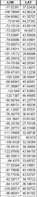
I believe it is in decimal degrees. This is a screenshot of some of the table's values. They do not line up.
- Mark as New
- Bookmark
- Subscribe
- Mute
- Subscribe to RSS Feed
- Permalink
Hi Austin,
Order of operations can make a big difference with event layers, so I'm wondering if something is just going awry in the process. Can we try this?
- Open a new blank ArcMap map or insert a new data frame into an existing map.
- File > Add Data > Add XY Data
- In the dialogue, click the Edit... button under Coordinate System of Input Coordinates and specify the correct GCS (is it possible these were collected in WGS 1984? Maybe try this workflow with both WGS 1984 and NAD 83?)
- Once the XY Event layer is added, add your polygon reference data that's in USA_Contiguous_Albers_Equal_Area_Conic
- Right-click on the Data Frame > Properties > Coordinate System and change it to USA_Contiguous_Albers_Equal_Area_Conic
Does the data line up? Fingers crossed!
Best,
Lauren
- Mark as New
- Bookmark
- Subscribe
- Mute
- Subscribe to RSS Feed
- Permalink
Hi Lauren, thank you for your input. Unfortunately that does not appear to resolve the problem. I received the below map whether I had the xy layer in WGS 1984 or NAD 83.

- Mark as New
- Bookmark
- Subscribe
- Mute
- Subscribe to RSS Feed
- Permalink
- Mark as New
- Bookmark
- Subscribe
- Mute
- Subscribe to RSS Feed
- Permalink
Hi Lauren,
Thank you for your input. Your response and your previous response gave me an idea that I may have messed up the data and not just how I'm, inputting it. I refreshed it and was able to map it like so:
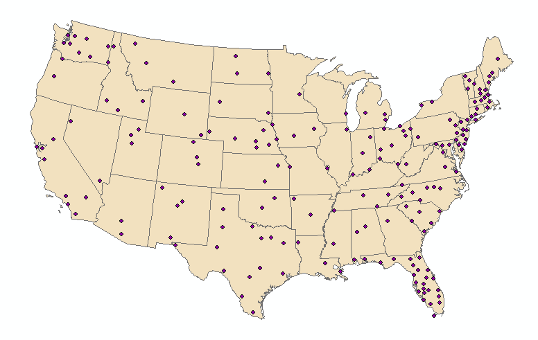
Which is nearly correct. I still have a minor mapping problem as some of the towns are actually in the bodies of water instead of on land:

Is there any advice you could offer towards minute adjustments that would fix this? Thank you for your time!