Turn on suggestions
Auto-suggest helps you quickly narrow down your search results by suggesting possible matches as you type.
Cancel
- Home
- :
- All Communities
- :
- Products
- :
- Data Management
- :
- Data Management Questions
- :
- Re: Workflows for managing and serving elevation d...
Options
- Subscribe to RSS Feed
- Mark Topic as New
- Mark Topic as Read
- Float this Topic for Current User
- Bookmark
- Subscribe
- Mute
- Printer Friendly Page
Workflows for managing and serving elevation data
Subscribe
2850
4
03-29-2013 05:13 PM
03-29-2013
05:13 PM
- Mark as New
- Bookmark
- Subscribe
- Mute
- Subscribe to RSS Feed
- Permalink
Esri is publishing documentation regarding workflows and best practices for management and serving of elevation data. The detailed workflow appears as a chapter in the Image Management Guidebook in the ArcGIS Help system. Recommendations for other types of imagery (preprocessed orthophotos, high resolution satellite imagery, scanned maps, and more) will be added to this Guidebook as they become available.
The starting page for information regarding these Image Management Workflows is here.
The elevation workflow is implemented in a Python script with an associated configuration file, based on MDCS (Mosaic Dataset Configuration Script). MDCS automates the process of creating and configuring mosaic datasets, then populating them with data. MDCS uses detailed configuration files to encapsulate �??best practices�?� for complete end-to-end processing of different image types. MDCS is available for free download in ArcGIS Online (see this group), along with sample data and template configuration files that may be modified for your unique data and requirements.
This post will provide a starting point for users to share questions and answers regarding the elevation workflow. If you have contributions to this discussion, please respond to this post. If you feel a need to begin a new post, please be sure to TAG the post with image_management, workflow, and MDCS so others may search for related posts.
4 Replies
03-30-2013
01:52 AM
- Mark as New
- Bookmark
- Subscribe
- Mute
- Subscribe to RSS Feed
- Permalink
Thanks, Cody,
The scripts like �??MDCS�?? (http://bit.ly/Owa2D6 ) under the ArcGIS Image Management Workflows (http://bit.ly/Z7kbNC) looks only available to the ArcGIS Online 'business' accounts. Is it correct?
Do we have any other ways to get it?
Regards,
Larry @ Aramco
The scripts like �??MDCS�?? (http://bit.ly/Owa2D6 ) under the ArcGIS Image Management Workflows (http://bit.ly/Z7kbNC) looks only available to the ArcGIS Online 'business' accounts. Is it correct?
Do we have any other ways to get it?
Regards,
Larry @ Aramco
05-07-2013
03:11 PM
- Mark as New
- Bookmark
- Subscribe
- Mute
- Subscribe to RSS Feed
- Permalink
Larry
The SECOND link you posted (http://bit.ly/Z7kbNC) goes to a Group on ArcGIS Online where you should find downloadable items related to the ArcGIS Image Management Workflows. There are currently 3 items, but more will appear in the future. There is a downloadable ZIP file that contains the �??MDCS�?? script - I'll include a direct link HERE.
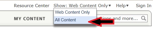
I suspect that the reason you did not find these items is that ArcGIS Online has a setting for "Show: Web Content Only" that you would need to change to "Show: All Content". See this screenshot:
[ATTACH=CONFIG]24116[/ATTACH]
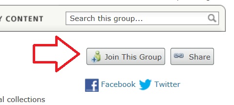
The FIRST link you posted (http://bit.ly/Owa2D6 ) leads to the ArcGIS Online Group that shows example live image services for worldwide elevation data. This group is different, and you will have to JOIN the group before you will be able to see the items. After logging in using your Esri Global ID, click on the gray "Join this Group" button to send a request - you should be approved to join the group within 24 to 48 hours.
[ATTACH=CONFIG]24117[/ATTACH]
*NOTE - this group regarding live elevation services may be changing soon. If the link above does not work, please try Searching for Groups, and enter "World Elevation Services".
Please let me know if you still have problems or questions. Thanks!
Cody Benkelman
The SECOND link you posted (http://bit.ly/Z7kbNC) goes to a Group on ArcGIS Online where you should find downloadable items related to the ArcGIS Image Management Workflows. There are currently 3 items, but more will appear in the future. There is a downloadable ZIP file that contains the �??MDCS�?? script - I'll include a direct link HERE.
I suspect that the reason you did not find these items is that ArcGIS Online has a setting for "Show: Web Content Only" that you would need to change to "Show: All Content". See this screenshot:
[ATTACH=CONFIG]24116[/ATTACH]
The FIRST link you posted (http://bit.ly/Owa2D6 ) leads to the ArcGIS Online Group that shows example live image services for worldwide elevation data. This group is different, and you will have to JOIN the group before you will be able to see the items. After logging in using your Esri Global ID, click on the gray "Join this Group" button to send a request - you should be approved to join the group within 24 to 48 hours.
[ATTACH=CONFIG]24117[/ATTACH]
*NOTE - this group regarding live elevation services may be changing soon. If the link above does not work, please try Searching for Groups, and enter "World Elevation Services".
Please let me know if you still have problems or questions. Thanks!
Cody Benkelman
05-19-2013
01:20 AM
- Mark as New
- Bookmark
- Subscribe
- Mute
- Subscribe to RSS Feed
- Permalink
Larry
The SECOND link you posted (http://bit.ly/Z7kbNC) goes to a Group on ArcGIS Online where you should find downloadable items related to the ArcGIS Image Management Workflows. There are currently 3 items, but more will appear in the future. There is a downloadable ZIP file that contains the �??MDCS�?? script - I'll include a direct link HERE.
I suspect that the reason you did not find these items is that ArcGIS Online has a setting for "Show: Web Content Only" that you would need to change to "Show: All Content". See this screenshot:
[ATTACH=CONFIG]24116[/ATTACH]
The FIRST link you posted (http://bit.ly/Owa2D6 ) leads to the ArcGIS Online Group that shows example live image services for worldwide elevation data. This group is different, and you will have to JOIN the group before you will be able to see the items. After logging in using your Esri Global ID, click on the gray "Join this Group" button to send a request - you should be approved to join the group within 24 to 48 hours.
[ATTACH=CONFIG]24117[/ATTACH]
*NOTE - this group regarding live elevation services may be changing soon. If the link above does not work, please try Searching for Groups, and enter "World Elevation Services".
Please let me know if you still have problems or questions. Thanks!
Cody Benkelman
Thanks a lot, Cody.
The script is already available to me.
Besides, it looks that the personal (public) account is not allowed to access "world elevation services".
{The message shows: "Unable to apply to join this group. A Public Account cannot apply to join a group owned by an organization."]
To me, this group owned by ESRI, do we have any other way to access?
...
Regards,
Larry @ Aramco
05-20-2013
05:06 PM
- Mark as New
- Bookmark
- Subscribe
- Mute
- Subscribe to RSS Feed
- Permalink
Larry
My apologies - I misunderstood your question.
A change was recently made to ArcGIS Online, and the World Elevation group (with a live, example implementation of these workflows) now requires login with an Esri Global ID that is under an Organization Subscription account. Some groups on ArcGIS Online are freely accessible, but this group is no longer accessible with a free public account.
Please note, the limited access applies only to the group you reference in your link , and that group will be changing soon when the World Elevation services are officially released. Your second link, and all of the other resources noted at the top of this post, remain available to all users.
Cody Benkelman