Turn on suggestions
Auto-suggest helps you quickly narrow down your search results by suggesting possible matches as you type.
Cancel
- Home
- :
- All Communities
- :
- Products
- :
- Data Management
- :
- Data Management Questions
- :
- White lines seen after mosaic
Options
- Subscribe to RSS Feed
- Mark Topic as New
- Mark Topic as Read
- Float this Topic for Current User
- Bookmark
- Subscribe
- Mute
- Printer Friendly Page
White lines seen after mosaic
Subscribe
1404
2
10-05-2012 01:52 AM
10-05-2012
01:52 AM
- Mark as New
- Bookmark
- Subscribe
- Mute
- Subscribe to RSS Feed
- Permalink
Hi,
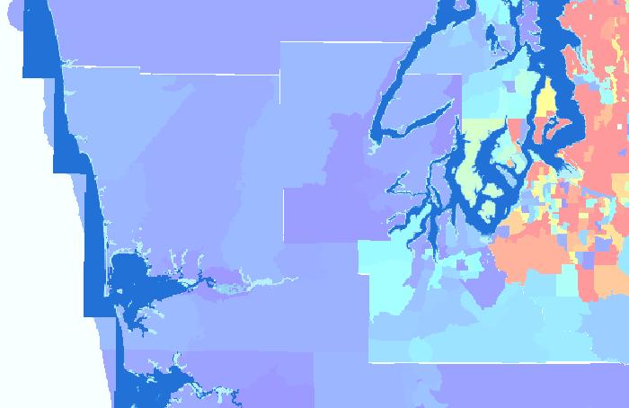
I had converted several polygons to shapefile and merged all the shapefiles using the "mosaic to new raster" function. After merging, there were white lines at the edge of each region. I thought that the "mosaic to new raster" function would smoothen the edge?
How do I remove these lines so that the edges are uniform? I have attached the image here.
As i am still new to this software, I hope that someone can guide me along here. Many many thanks in advance.
Bernard
2 Replies
10-05-2012
07:11 AM
- Mark as New
- Bookmark
- Subscribe
- Mute
- Subscribe to RSS Feed
- Permalink
Bernard,
You're talking about polygons (vector) and shapefiles (vector) but then you used the mosaic to new raster tool. Unless you actually want raster data, I think you should use the Merge tool.
http://resources.arcgis.com/en/help/main/10.1/index.html#//001700000055000000
Ryan
You're talking about polygons (vector) and shapefiles (vector) but then you used the mosaic to new raster tool. Unless you actually want raster data, I think you should use the Merge tool.
http://resources.arcgis.com/en/help/main/10.1/index.html#//001700000055000000
Ryan
10-09-2012
01:33 AM
- Mark as New
- Bookmark
- Subscribe
- Mute
- Subscribe to RSS Feed
- Permalink
Hi Ryan,
Thank you for your response.
Actually I intend to get the censor data of several county. For each county, I created a separate dbf file and combine the census data to shapefile for the county obtained from TIGER.
Now that all the polygons has the required census data, I want to merge all of them so that a single output will show the census information of different county.
When I merged using the polygon, my census data is not presented. So i decided to convert to a raster then merge the raster together. But as you can see, theres white lines at some portion.
What should be my next course of action? I want to remove those white lines.
THanks,
Bernard