Turn on suggestions
Auto-suggest helps you quickly narrow down your search results by suggesting possible matches as you type.
Cancel
- Home
- :
- All Communities
- :
- Products
- :
- Data Management
- :
- Data Management Questions
- :
- Re: Which Interpolation should I Use?
Options
- Subscribe to RSS Feed
- Mark Topic as New
- Mark Topic as Read
- Float this Topic for Current User
- Bookmark
- Subscribe
- Mute
- Printer Friendly Page
Which Interpolation should I Use?
Subscribe
1787
2
05-07-2012 05:51 AM
05-07-2012
05:51 AM
- Mark as New
- Bookmark
- Subscribe
- Mute
- Subscribe to RSS Feed
- Permalink
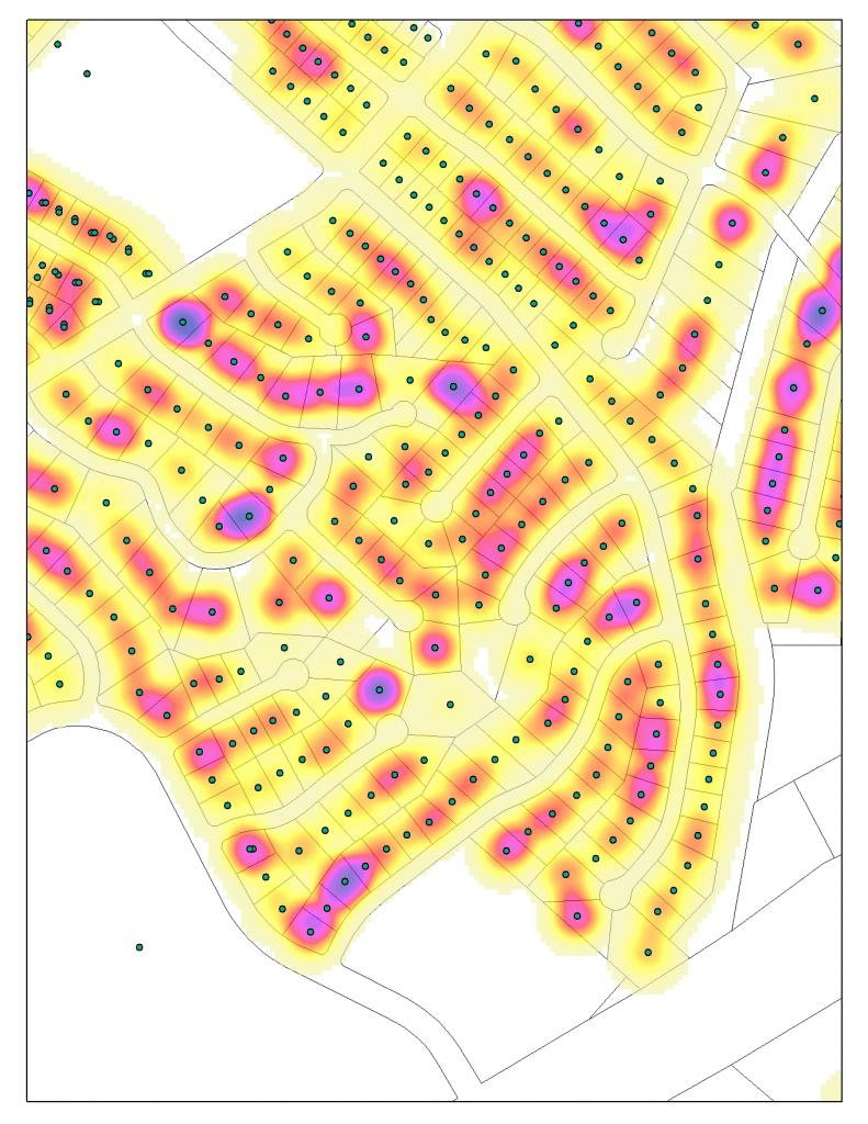
I have Water and Electric consumtion data that I am attempting to make into a raster data set. I would like said raster to look like what was created before but, cannont figure out what type of Interprolation I should use and what parameters to set. The water and electric consumption data is now joined to an 'Address Points' layer so that the useage is on top of the parcel that used the water/elevtricity.
How do I go from this...
[ATTACH=CONFIG]14131[/ATTACH]
To this....
[ATTACH=CONFIG]14132[/ATTACH]
Thanks,
Mike T In the BCS
How do I go from this...
[ATTACH=CONFIG]14131[/ATTACH]
To this....
[ATTACH=CONFIG]14132[/ATTACH]
Thanks,
Mike T In the BCS
2 Replies
05-07-2012
07:16 AM
- Mark as New
- Bookmark
- Subscribe
- Mute
- Subscribe to RSS Feed
- Permalink
I would probably recommend one of the density tools based on your screenshots. I am not sure if you want to truly interpolate to create a complete surface. The Point Density tool will probably create the desired output.
by
Anonymous User
Not applicable
05-07-2012
01:08 PM
- Mark as New
- Bookmark
- Subscribe
- Mute
- Subscribe to RSS Feed
- Permalink
Original User: bjardot
I agree with the above comment but, Looks like IDW with a very high power, set the neighbors to 1. Experiment with the powers and neighbors. Go low on Neighbors and High on Power. Could set the search radius to fixed, and set that to a very low number, like half the distance from point to point/house to house. Good luck.
I agree with the above comment but, Looks like IDW with a very high power, set the neighbors to 1. Experiment with the powers and neighbors. Go low on Neighbors and High on Power. Could set the search radius to fixed, and set that to a very low number, like half the distance from point to point/house to house. Good luck.