Turn on suggestions
Auto-suggest helps you quickly narrow down your search results by suggesting possible matches as you type.
Cancel
- Home
- :
- All Communities
- :
- Products
- :
- Data Management
- :
- Data Management Questions
- :
- Re: �??US Dual Range Addresses�?� style issue,
Options
- Subscribe to RSS Feed
- Mark Topic as New
- Mark Topic as Read
- Float this Topic for Current User
- Bookmark
- Subscribe
- Mute
- Printer Friendly Page
�??US Dual Range Addresses�?� style issue,
Subscribe
7574
16
04-06-2014 09:18 AM
04-06-2014
09:18 AM
- Mark as New
- Bookmark
- Subscribe
- Mute
- Subscribe to RSS Feed
- Permalink
�??US Dual Range Addresses�?� style issue,
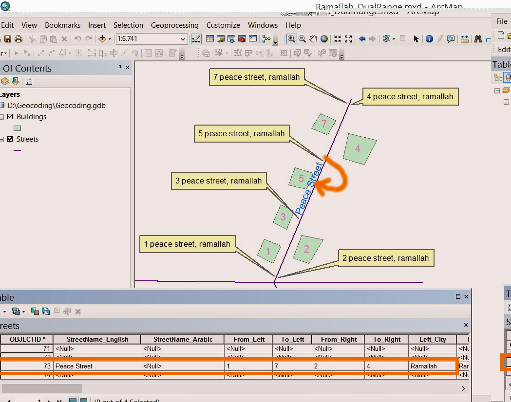
I wanted to apply the �??US Dual Range Addresses�?� style but it appears that the searched addresses don�??t match the exact location of the target building.
For example, in the screenshot below, I wanted to search the �??5 peace street, Ramallah�?�. The result doesn�??t match the precise physical location of the building. In other words, how to have the location of the found building just precisely in front of the building. The schema is also shown in the screenshot.
[ATTACH=CONFIG]32846[/ATTACH]
I still need to use the �??Street�?� layer as REFERENCE DATA but I�??m looking for having the precise location of the searched building.
What other options I might still have?
Thank you
Best
Jamal
----------------------------------------
Jamal Numan
Geomolg Geoportal for Spatial Information
Ramallah, West Bank, Palestine
Jamal Numan
Geomolg Geoportal for Spatial Information
Ramallah, West Bank, Palestine
16 Replies
04-06-2014
10:13 AM
- Mark as New
- Bookmark
- Subscribe
- Mute
- Subscribe to RSS Feed
- Permalink
�??US Dual Range Addresses�?� style issue,
I wanted to apply the �??US Dual Range Addresses�?� style but it appears that the searched addresses don�??t match the exact location of the target building.
For example, in the screenshot below, I wanted to search the �??5 peace street, Ramallah�?�. The result doesn�??t match the precise physical location of the building. In other words, how to have the location of the found building just precisely in front of the building. The schema is also shown in the screenshot.
[ATTACH=CONFIG]32846[/ATTACH]
I still need to use the �??Street�?� layer as REFERENCE DATA but I�??m looking for having the precise location of the searched building.
What other options I might still have?
Thank you
Best
Jamal
Cont.
In return, I we apply the �??US Single House Addresses�?� style, we can ending up by finding the exact location of each address. But in this case, we need the data at the level of buildings:
1. This data is expected to be massive and �??bigger�?� than the data of streets (number of features)
2. The level of update is very extensive. Each new constructed building must be added to the building layer.
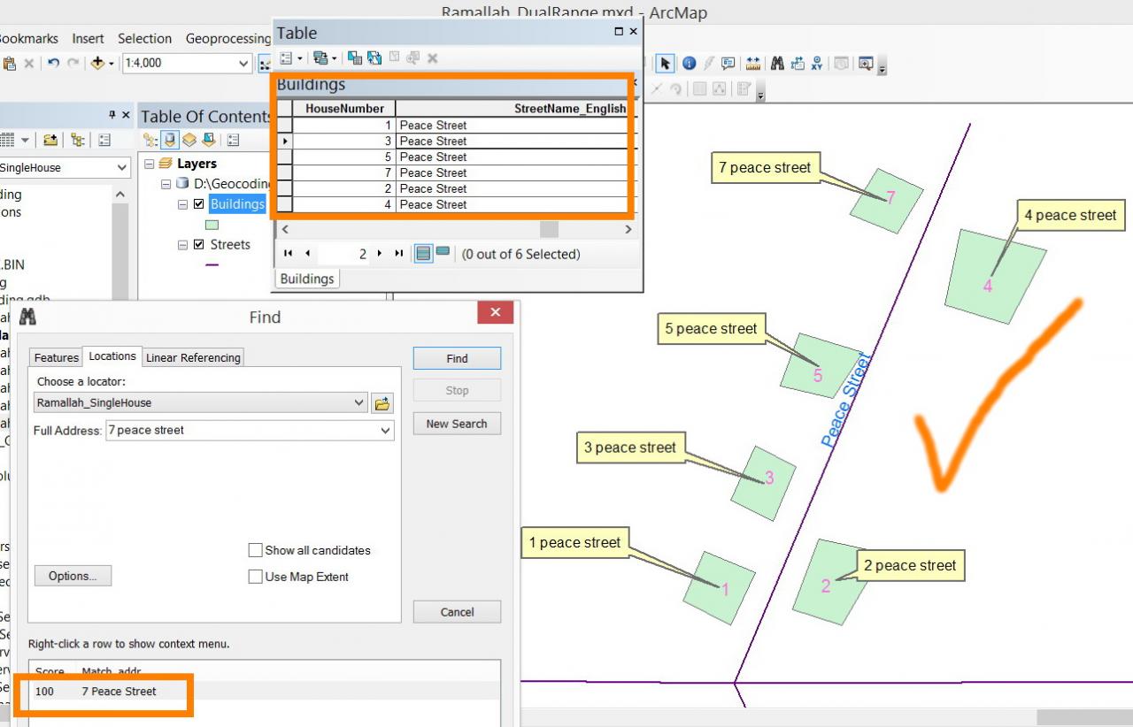
What I�??m looking for is to keep the reference data to be the street to find a way to have exact location as in the case of �??US Single House Addresses�?� style as shown in the screenshot below:
[ATTACH=CONFIG]32848[/ATTACH]
Is that possible?
----------------------------------------
Jamal Numan
Geomolg Geoportal for Spatial Information
Ramallah, West Bank, Palestine
Jamal Numan
Geomolg Geoportal for Spatial Information
Ramallah, West Bank, Palestine
04-07-2014
04:34 AM
- Mark as New
- Bookmark
- Subscribe
- Mute
- Subscribe to RSS Feed
- Permalink
Jamal,
With a locator based on street ranges, it will never plot exactly on buildings, unless the buildings are right on the street and your ranges are setup perfect.
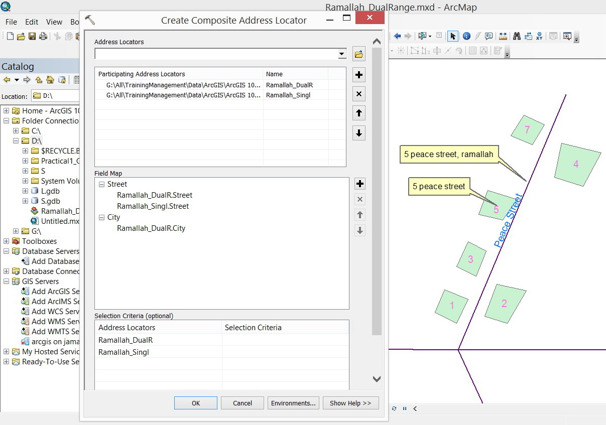
The closest to perfect you can get is using a composite address locator.
If you use your building layer first and street second. It should first look at your building layer, if an address is found you will get the exact location, if not you will at least get an approximate location by using your street address locator.
Hope this helps!
Tim
With a locator based on street ranges, it will never plot exactly on buildings, unless the buildings are right on the street and your ranges are setup perfect.
The closest to perfect you can get is using a composite address locator.
If you use your building layer first and street second. It should first look at your building layer, if an address is found you will get the exact location, if not you will at least get an approximate location by using your street address locator.
Hope this helps!
Tim
04-07-2014
12:31 PM
- Mark as New
- Bookmark
- Subscribe
- Mute
- Subscribe to RSS Feed
- Permalink
Jamal,
With a locator based on street ranges, it will never plot exactly on buildings, unless the buildings are right on the street and your ranges are setup perfect.
The closest to perfect you can get is using a composite address locator.
If you use your building layer first and street second. It should first look at your building layer, if an address is found you will get the exact location, if not you will at least get an approximate location by using your street address locator.
Hope this helps!
Tim
Thanks Tim.
I couldn�??t understand the assumption of the �??Dual Range�?� style. How come does it assume that buildings are equally paced on the left\right of a street? Does this model the real life?
For example, if we apply the �??Dual Range�?� in �??Peace Street�?� (as shown in the screenshot below) then the location identified by the �??Dual Range�?� style is not in the actual location of the building.
[ATTACH=CONFIG]32886[/ATTACH]
In my country, it never happens that buildings are equally paced on the left\right of streets. Then which style should I use?
I don�??t need to go for the �??Single House�?� style as it requires digitizing all the houses (at least as points) in a particular area to apply this style.
Two options:
�?� �??Dual Range�?�: doesn�??t locate the precise location of the address due to the fact that the buildings are not equally paced in the real life.
�?� �??Single House�?�: requires a data entry at the level of buildings (at least as points) to be able to locate their addresses. Each new building must be added to the reference data and thus extensive work is a must if the �??Single House�?� is applied
Which style can replace these two considering only their advantages?
Applying the �??composite address locator�?� doesn�??t solve the issue as it will be finally using the two styles �??Dual Range�?� and �??Single House�?� with their exact behavior.
[ATTACH=CONFIG]32887[/ATTACH], [ATTACH=CONFIG]32888[/ATTACH]
----------------------------------------
Jamal Numan
Geomolg Geoportal for Spatial Information
Ramallah, West Bank, Palestine
Jamal Numan
Geomolg Geoportal for Spatial Information
Ramallah, West Bank, Palestine
04-07-2014
12:52 PM
- Mark as New
- Bookmark
- Subscribe
- Mute
- Subscribe to RSS Feed
- Permalink
Jamal,
The "Dual Ranges" style uses interpolation as an approximation of the position along the street that an address should be. The only style that would be more precise would be the "Single House" style which would require an address point for each house. Is there a reason that the exact location is needed for the geocode? If so, the "Single House" style is your only option and will require a lot of work to add every house to the dataset.
Brad
04-07-2014
10:09 PM
- Mark as New
- Bookmark
- Subscribe
- Mute
- Subscribe to RSS Feed
- Permalink
Jamal,
The "Dual Ranges" style uses interpolation as an approximation of the position along the street that an address should be. The only style that would be more precise would be the "Single House" style which would require an address point for each house. Is there a reason that the exact location is needed for the geocode? If so, the "Single House" style is your only option and will require a lot of work to add every house to the dataset.
Brad
Thank you very much Brad for the input.
Sure, end users prefer to see geocoded address in the precise place.
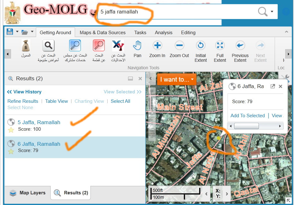
[ATTACH=CONFIG]32897[/ATTACH]
Do you mean that the Google database of addresses, for example, is collected at the level of each building as the found addresses match the precise location of the target?
[ATTACH=CONFIG]32898[/ATTACH]
----------------------------------------
Jamal Numan
Geomolg Geoportal for Spatial Information
Ramallah, West Bank, Palestine
Jamal Numan
Geomolg Geoportal for Spatial Information
Ramallah, West Bank, Palestine
04-08-2014
11:34 AM
- Mark as New
- Bookmark
- Subscribe
- Mute
- Subscribe to RSS Feed
- Permalink
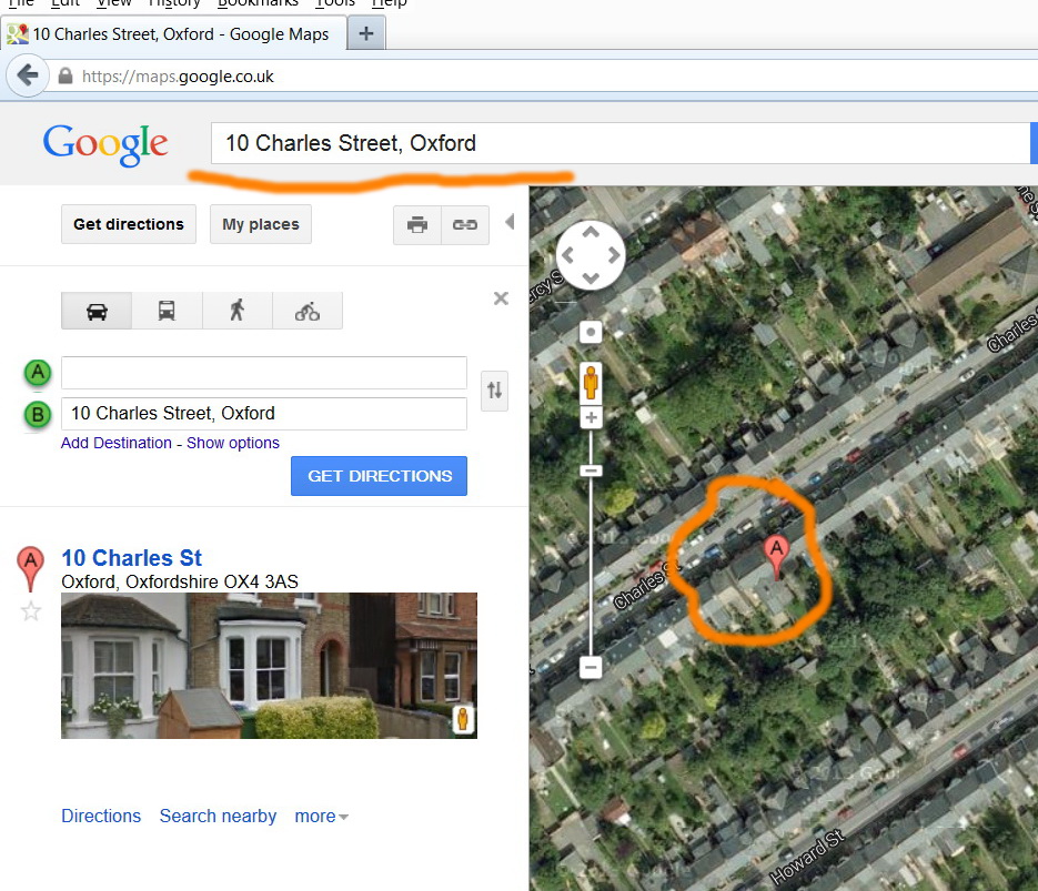
Thank you very much Brad for the input.
Sure, end users prefer to see geocoded address in the precise place.
[ATTACH=CONFIG]32897[/ATTACH]
Do you mean that the Google database of addresses, for example, is collected at the level of each building as the found addresses match the precise location of the target?
[ATTACH=CONFIG]32898[/ATTACH]
It boils down to what your use is and what your budget is, and how they balance each other: As has been described, anytime you interpolate an address based on a linear feature, you accuracy is okay, but your precision suffers. That's just the name of the beast. Lets say you have a street that is ranged from 100-198 and 101-199 on the even and odd sides respectively. That locator will interpolate house number 150 right in the middle of the block on the even side; the reality might be that its really on the odd side and at the 199 end of the block.
If block level accuracy is 'good enough' then your are good to go. However, if you need better precision than that (like the actual location of house #150) you'll need different data with which to match. Accuracy might cost you $X, while Precision might cost you $X * 5. However, what is the result of an accurate location versus a precise location? That's something only you can answer.
That should just about do it....
04-08-2014
12:09 PM
- Mark as New
- Bookmark
- Subscribe
- Mute
- Subscribe to RSS Feed
- Permalink
It boils down to what your use is and what your budget is, and how they balance each other: As has been described, anytime you interpolate an address based on a linear feature, you accuracy is okay, but your precision suffers. That's just the name of the beast. Lets say you have a street that is ranged from 100-198 and 101-199 on the even and odd sides respectively. That locator will interpolate house number 150 right in the middle of the block on the even side; the reality might be that its really on the odd side and at the 199 end of the block.
If block level accuracy is 'good enough' then your are good to go. However, if you need better precision than that (like the actual location of house #150) you'll need different data with which to match. Accuracy might cost you $X, while Precision might cost you $X * 5. However, what is the result of an accurate location versus a precise location? That's something only you can answer.
Thank you Joe for the useful answer.
In my case, I wanted to explore if there is a more innovative approach to use the �??Dual Range�?� style but at the same time to find the EXACT location of the geocoded address.
----------------------------------------
Jamal Numan
Geomolg Geoportal for Spatial Information
Ramallah, West Bank, Palestine
Jamal Numan
Geomolg Geoportal for Spatial Information
Ramallah, West Bank, Palestine
04-08-2014
04:58 PM
- Mark as New
- Bookmark
- Subscribe
- Mute
- Subscribe to RSS Feed
- Permalink
Thank you Joe for the useful answer.
In my case, I wanted to explore if there is a more innovative approach to use the �??Dual Range�?� style but at the same time to find the EXACT location of the geocoded address.
I've known people to address range their streets to the actual physical addresses. Personally I think that's a complete waste of time and energy. I mean, if you have the actual physical addresses, why not create and use points?
The thing is, using a linear feature is always going to be using a linear feature. It's cheap and easy and there's lots of data out there to use. But it has it's limitations and no matter how hard you try, those limitations will prevail.
I have a colleague who made a great comment in a similar discussion: "What if the Census Bureau /Tiger/DIME files started as points instead of lines? Do you think things would be different today?" Jamal I know you are not in the US but way way way back in the day, Tiger files were all we had to work with. We've come a long way in data quality, but a line is still a line.
That should just about do it....
04-09-2014
12:53 AM
- Mark as New
- Bookmark
- Subscribe
- Mute
- Subscribe to RSS Feed
- Permalink
I've known people to address range their streets to the actual physical addresses. Personally I think that's a complete waste of time and energy. I mean, if you have the actual physical addresses, why not create and use points?
The thing is, using a linear feature is always going to be using a linear feature. It's cheap and easy and there's lots of data out there to use. But it has it's limitations and no matter how hard you try, those limitations will prevail.
I have a colleague who made a great comment in a similar discussion: "What if the Census Bureau /Tiger/DIME files started as points instead of lines? Do you think things would be different today?" Jamal I know you are not in the US but way way way back in the day, Tiger files were all we had to work with. We've come a long way in data quality, but a line is still a line.
Thanks Joe,
Then there is no option but to use �??Single House�?� style if I need to find the exact location of the target building.
Best
Jamal
----------------------------------------
Jamal Numan
Geomolg Geoportal for Spatial Information
Ramallah, West Bank, Palestine
Jamal Numan
Geomolg Geoportal for Spatial Information
Ramallah, West Bank, Palestine