- Home
- :
- All Communities
- :
- Products
- :
- Data Management
- :
- Data Management Questions
- :
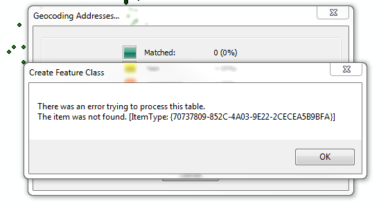
- There was an error trying to process this table.
- Subscribe to RSS Feed
- Mark Topic as New
- Mark Topic as Read
- Float this Topic for Current User
- Bookmark
- Subscribe
- Mute
- Printer Friendly Page
There was an error trying to process this table.
- Mark as New
- Bookmark
- Subscribe
- Mute
- Subscribe to RSS Feed
- Permalink
Any ideas?
Thanks.
- Mark as New
- Bookmark
- Subscribe
- Mute
- Subscribe to RSS Feed
- Permalink
Back to basics in this comment... does anyone know where to find an example of how a table should be formatted? Like, I assume I can start in excel and if I follow all the right rules it will come in, but for the life of me I can't find any instructions in the ESRI help for what the input table should look like! From skimming this thread, it seems like I need headers of some sort? No spaces in the header? Can addresses themselves have spaces? Help! I can't get past 0%
- Mark as New
- Bookmark
- Subscribe
- Mute
- Subscribe to RSS Feed
- Permalink
Jennifer:
If you are using Excel spreadsheets as the input table for geocoding the following help topic will help get you on your way.
https://pro.arcgis.com/en/pro-app/help/data/excel/work-with-excel-in-arcgis-pro.htm
Here are some other resources for tables:
http://desktop.arcgis.com/en/arcmap/latest/manage-data/tables/defining-tables.htm#GUID-C2CB2F27-352A-48A2-A863-F9E45DBD11E9
-Shana
- Mark as New
- Bookmark
- Subscribe
- Mute
- Subscribe to RSS Feed
- Permalink
My solution was to geocode into a gdb and not a shp. I used an xlsx sheet and a csv.
- Mark as New
- Bookmark
- Subscribe
- Mute
- Subscribe to RSS Feed
- Permalink
Agnes:
It's possible that there was a field type in your table that was not supported by shapefile format, which could explain why using a file gdb for geocode output worked.
- Mark as New
- Bookmark
- Subscribe
- Mute
- Subscribe to RSS Feed
- Permalink
Hey everyone,
Just wanted to add to this conversation. I was receiving this error when trying to geocode a csv to a feature class:
And I went through a variety of steps to try to resolve:
- checked field names
- checked for weird characters in the addresses
But then I tried exporting as a shapefile instead of a feature class and it worked great. Hope this helps!
- « Previous
- Next »
- « Previous
- Next »