Turn on suggestions
Auto-suggest helps you quickly narrow down your search results by suggesting possible matches as you type.
Cancel
- Home
- :
- All Communities
- :
- Products
- :
- Data Management
- :
- Data Management Questions
- :
- Re: Tasseled Cap using Landsat 5 TM .tiffs in ArcM...
Options
- Subscribe to RSS Feed
- Mark Topic as New
- Mark Topic as Read
- Float this Topic for Current User
- Bookmark
- Subscribe
- Mute
- Printer Friendly Page
Tasseled Cap using Landsat 5 TM .tiffs in ArcMap 10.1
Subscribe
5821
3
03-27-2013 07:08 PM
03-27-2013
07:08 PM
- Mark as New
- Bookmark
- Subscribe
- Mute
- Subscribe to RSS Feed
- Permalink
Hi, I am trying to use one of the new Raster Functions, the Tasseled Cap Index, on Landsat 5 TM tiff images in ArcMap 10.1, but can't seem to figure it out. Doesn't seem like anyone else has tried and failed at this as I have combed the internet looking for any help. Looks like someone at ESRI has accomplished this, as it shows on the resources.argis.com site, but doesn't explain how to get the rsame results. Help please: What bands should I apply the function to? Should they be mosaicked, or not? Is there anyway to tell if the pansharpening or stretch functions have been applied, so that I can remove them? Thanks!
3 Replies
03-29-2013
06:43 AM
- Mark as New
- Bookmark
- Subscribe
- Mute
- Subscribe to RSS Feed
- Permalink
According to the mosaic dataset function, it should be used on raw data and have the proper metadata.
If it does not, then you will need to acquire the raw data. You should be able to apply it to a raster with the fx on the Image Analysis Window or when the data is added to a mosaic dataset
The input for this function is the raster. There are no other parameters for this function because all the information is derived from the input's properties and key metadata (bands, data type, and sensor name). Only imagery from the Landsat MSS, Landsat TM, Landsat ETM+, IKONOS, and QuickBird sensors are supported.
If it does not, then you will need to acquire the raw data. You should be able to apply it to a raster with the fx on the Image Analysis Window or when the data is added to a mosaic dataset
12-17-2013
03:34 AM
- Mark as New
- Bookmark
- Subscribe
- Mute
- Subscribe to RSS Feed
- Permalink
Hi there!
I am having about the same Problem. I have used raw .tif files bands 1-5 and band 7. Those i have integrated into a "composit bands" file with the corresponding arcgis tool.
There after I tried to apply the tasseled cap function via "raster function Editor", resulting in the following error message: "function could not be insertet. Input or Output arguments are invalid."
Please help!
07-27-2015
01:37 PM
- Mark as New
- Bookmark
- Subscribe
- Mute
- Subscribe to RSS Feed
- Permalink
Hi Codie,
If you want to apply just the greenness variable, you could use Raster Calculator.
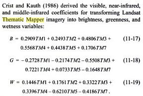
Add TM1-5 and TM7 to ArcMap.
Open Raster Calculator (Spatial Analyst) and write the expression similar to that given below:
Float (((-0.2728)*TM1) - ((0.2174)*TM2) - ((0.5508)*TM3) + ((0.7221)*TM4) + ((0.0733)*TM5) - ((0.1648)*TM7))
Note: Replace "TM1-5" and "TM7" with the corresponding band names.
Think Location