Turn on suggestions
Auto-suggest helps you quickly narrow down your search results by suggesting possible matches as you type.
Cancel
- Home
- :
- All Communities
- :
- Products
- :
- Data Management
- :
- Data Management Questions
- :
- Re: SDTS Raster to Grid Conversion in ArcGIS 10
Options
- Subscribe to RSS Feed
- Mark Topic as New
- Mark Topic as Read
- Float this Topic for Current User
- Bookmark
- Subscribe
- Mute
- Printer Friendly Page
SDTS Raster to Grid Conversion in ArcGIS 10
Subscribe
6701
10
09-10-2012 07:53 PM
09-10-2012
07:53 PM
- Mark as New
- Bookmark
- Subscribe
- Mute
- Subscribe to RSS Feed
- Permalink
Hi, fellow scroungers of online data,
The SDTS Raster to Grid Conversion command button, available in arc 9.3 allows us to convert the digital elevation model data, available online from the US Geological Survey gis data website. The DEM data converted to grid, with the command button, can then be processed, by spatial analyst tools, to make contour lines. I can not find this conversion command button in the customize commands list for GIS 10.0. How is this conversion is being done by users of Arc 10.0?
Ken
10 Replies
09-11-2012
10:30 AM
- Mark as New
- Bookmark
- Subscribe
- Mute
- Subscribe to RSS Feed
- Permalink
Hi Ken,
Have you tried just adding the data to ArcMap? SDTS (DEM) is listed as a supported format in terms of reading ability. If you need it in another format you can just run Copy Raster tool.
Best Regards,
Eric
Have you tried just adding the data to ArcMap? SDTS (DEM) is listed as a supported format in terms of reading ability. If you need it in another format you can just run Copy Raster tool.
Best Regards,
Eric
09-11-2012
11:45 AM
- Mark as New
- Bookmark
- Subscribe
- Mute
- Subscribe to RSS Feed
- Permalink
If you are still looking for the Import from SDTS tool, you can install ArcInfo Workstation and then use the tool.
09-12-2012
02:58 PM
- Mark as New
- Bookmark
- Subscribe
- Mute
- Subscribe to RSS Feed
- Permalink
Eric,
The USGS STDS file would not add to arcmap. I can't run the copy raster tool until I get it into gis. I can't believe ESRI didn't include the STDS tool with Gis 10; if so it's a big oversite.
I've never installed workstation. To install Workstation do I need to install it completely from CD or is there a way to activate it from my ArcGIS 10 install package?
09-13-2012
04:26 AM
- Mark as New
- Bookmark
- Subscribe
- Mute
- Subscribe to RSS Feed
- Permalink
I would not consider it an oversight, the functionality is still available with ArcInfo Workstation as it was before. All of the coverage tools are available, but need Workstation to process them. Workstation is a separate download from the customer care portal and once it is downloaded the tools will be accessible. Once you have imported the SDTS, then you can proceed to use the Copy Raster tool. All of the coverage conversion tools require an ArcInfo license as indicated here.
09-13-2012
06:45 AM
- Mark as New
- Bookmark
- Subscribe
- Mute
- Subscribe to RSS Feed
- Permalink
Jeff,
Thanks so much for your thorough answer to my thread, espcially the link that shows what tools will work at license levels. The state gov computer I'm using has only a arcview license, so you saved me a bunch of time trying to get workstation on here, only to find out later that the tool will not work. I really appreciate the help.
Ken
09-13-2012
08:27 AM
- Mark as New
- Bookmark
- Subscribe
- Mute
- Subscribe to RSS Feed
- Permalink
Ken,
Is the data you have available for download? Could you point me in the right direction so I can download the same as you? SDTS dem data from USGS should just work in ArcGIS per the link I previously provided. If the data was just in-house data and not recently downloaded we can work together to get the data here via our ftp site. I'm more concerned about it not working in its native form. The only oversight would be if all SDTS raster data is not readable in ArcGIS. When the 8.x toolbar, which was VBA, was removed along with pretty much anything VBA in ArcGIS, we added native support for this format. At ArcGIS 10.1, customizations built using VBA are no longer supported. We began this transition in 10.0.
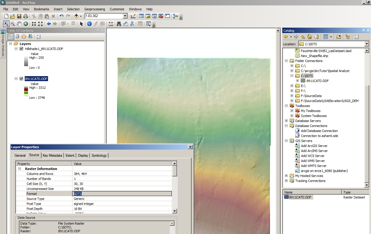
I downloaded sdts dem rasters from GeoCommunity this morning and after unzipping the file, I could add the .ddf file right into ArcMap and begin other processes such as hillshade, slope, and contour. Attached is the native sdts dem raster displaying in ArcMap 10.1. It should be the same for 10.0, and you should not have to run any conversion tool. Perhaps you could contact Esri Support so they can troubleshoot - they have better tools for interacting with you than I do here on the forums.
Best Regards,
Eric
Is the data you have available for download? Could you point me in the right direction so I can download the same as you? SDTS dem data from USGS should just work in ArcGIS per the link I previously provided. If the data was just in-house data and not recently downloaded we can work together to get the data here via our ftp site. I'm more concerned about it not working in its native form. The only oversight would be if all SDTS raster data is not readable in ArcGIS. When the 8.x toolbar, which was VBA, was removed along with pretty much anything VBA in ArcGIS, we added native support for this format. At ArcGIS 10.1, customizations built using VBA are no longer supported. We began this transition in 10.0.
I downloaded sdts dem rasters from GeoCommunity this morning and after unzipping the file, I could add the .ddf file right into ArcMap and begin other processes such as hillshade, slope, and contour. Attached is the native sdts dem raster displaying in ArcMap 10.1. It should be the same for 10.0, and you should not have to run any conversion tool. Perhaps you could contact Esri Support so they can troubleshoot - they have better tools for interacting with you than I do here on the forums.
Best Regards,
Eric
09-13-2012
09:59 AM
- Mark as New
- Bookmark
- Subscribe
- Mute
- Subscribe to RSS Feed
- Permalink
Eric Rice,
Thank you so much for experimenting with my problem. We need to process a lot of the USGS geocommunity Dem data to cover our project areas throughout Nevada. After reading about your efforts, and finding out that it worked for you, I got my office IT people involved: we think the problem is not GIS, rather the Windows 7 default zip file extraction tool appears not to be extracting the USGS data. Our theory is another app, such as WinZip, would work for extracting those geocomm .TAR files. Unfortunately, our state office does not have WinZip available for me to test. If you wouldn't mind hanging here with us just for one my test: if you would send me a USGS geocomm DEM file, that you unzipped/extracted, I'll attempt to add it directly to my arcview 10.0. What is your pc using to extract the data?
Ken
09-13-2012
11:51 AM
- Mark as New
- Bookmark
- Subscribe
- Mute
- Subscribe to RSS Feed
- Permalink
Ken,
I used WinRAR to extract the data. The forum will not let me attach this format directly. It would need to be zipped again. WinRAR is free if you can get approval to install it. WinZip should also work when dealing with .TAR.gz files.
Eric
I used WinRAR to extract the data. The forum will not let me attach this format directly. It would need to be zipped again. WinRAR is free if you can get approval to install it. WinZip should also work when dealing with .TAR.gz files.
Eric
09-15-2013
04:17 PM
- Mark as New
- Bookmark
- Subscribe
- Mute
- Subscribe to RSS Feed
- Permalink
i'v downloaded a 60 day trail version of arcGis - and would like to try to use the SDTS Raster to Grid dialog. does anyone know how someone with a trail version of arcGis could also get a trail version of arcInfo?!