Turn on suggestions
Auto-suggest helps you quickly narrow down your search results by suggesting possible matches as you type.
Cancel
- Home
- :
- All Communities
- :
- Products
- :
- Data Management
- :
- Data Management Questions
- :
- Scale Factor and Projection Issues
Options
- Subscribe to RSS Feed
- Mark Topic as New
- Mark Topic as Read
- Float this Topic for Current User
- Bookmark
- Subscribe
- Mute
- Printer Friendly Page
Scale Factor and Projection Issues
Subscribe
1714
1
03-26-2014 11:25 AM
03-26-2014
11:25 AM
- Mark as New
- Bookmark
- Subscribe
- Mute
- Subscribe to RSS Feed
- Permalink
Hello,
Hopefully I can describe the issue appropriately. I have received a geodatabase with feature classes developed from LiDAR data that was processed in Microstation. I know very little about what has been done to the data through this process but the files I do have are in the following projection:
NAD_1983_StatePlane_Idaho_East_FIPS_1101_Feet
WKID: 2241 Authority: EPSG
Projection: Transverse_Mercator
False_Easting: 656166.6666666665
False_Northing: 0.0
Central_Meridian: -112.1666666666667
Scale_Factor: 0.9999473684210526
Latitude_Of_Origin: 41.66666666666666
Linear Unit: Foot_US (0.3048006096012192)
Geographic Coordinate System: GCS_North_American_1983
Angular Unit: Degree (0.0174532925199433)
Prime Meridian: Greenwich (0.0)
Datum: D_North_American_1983
Spheroid: GRS_1980
Semimajor Axis: 6378137.0
Semiminor Axis: 6356752.314140356
Inverse Flattening: 298.257222101
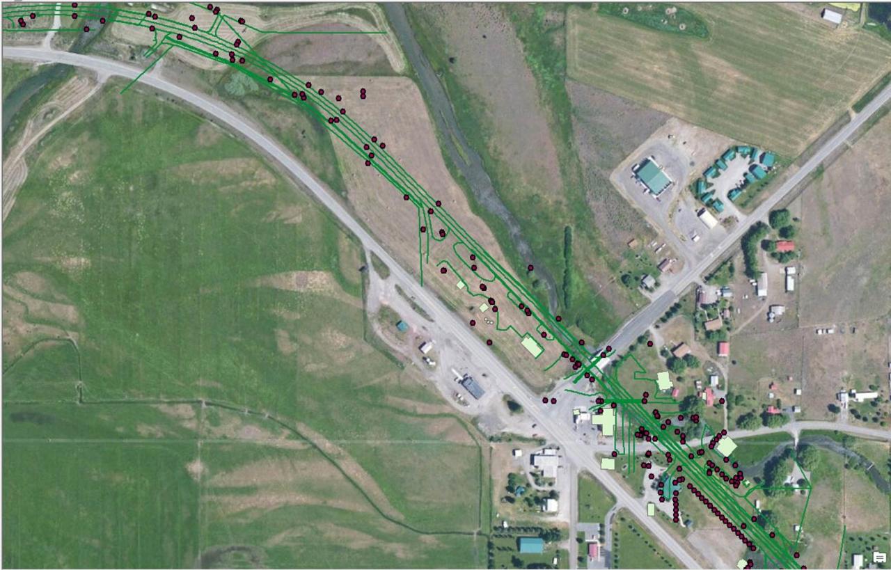
Everything looks good except they do not align with basemap imagery or other shapefiles in the same projection. Everything is approximately 200 ft to the NE or where it should be. Attached is an image of the alignment.
1) Is this a scale factor issue? How can I find the appropriate scale factor? I have shapefiles of similar data processed from the same lidar data that align without issue. The defined projection is the same in the shapefiles as the geodatabase.
2) Is this an issue with the processing within Microstation and any suggestions on how to fix it?
3) Are there any resources available that go into detail about the appropriate workflow from Mobile LiDAR data collection to CAD or MicroStation and then ArcGIS?
Thank you for any input on this issue.
Hopefully I can describe the issue appropriately. I have received a geodatabase with feature classes developed from LiDAR data that was processed in Microstation. I know very little about what has been done to the data through this process but the files I do have are in the following projection:
NAD_1983_StatePlane_Idaho_East_FIPS_1101_Feet
WKID: 2241 Authority: EPSG
Projection: Transverse_Mercator
False_Easting: 656166.6666666665
False_Northing: 0.0
Central_Meridian: -112.1666666666667
Scale_Factor: 0.9999473684210526
Latitude_Of_Origin: 41.66666666666666
Linear Unit: Foot_US (0.3048006096012192)
Geographic Coordinate System: GCS_North_American_1983
Angular Unit: Degree (0.0174532925199433)
Prime Meridian: Greenwich (0.0)
Datum: D_North_American_1983
Spheroid: GRS_1980
Semimajor Axis: 6378137.0
Semiminor Axis: 6356752.314140356
Inverse Flattening: 298.257222101
Everything looks good except they do not align with basemap imagery or other shapefiles in the same projection. Everything is approximately 200 ft to the NE or where it should be. Attached is an image of the alignment.
1) Is this a scale factor issue? How can I find the appropriate scale factor? I have shapefiles of similar data processed from the same lidar data that align without issue. The defined projection is the same in the shapefiles as the geodatabase.
2) Is this an issue with the processing within Microstation and any suggestions on how to fix it?
3) Are there any resources available that go into detail about the appropriate workflow from Mobile LiDAR data collection to CAD or MicroStation and then ArcGIS?
Thank you for any input on this issue.
1 Reply
03-27-2014
03:39 PM
- Mark as New
- Bookmark
- Subscribe
- Mute
- Subscribe to RSS Feed
- Permalink
No idea if this is related, but is this data DGN? And are you using 10.2.1? Or what version are you using? As reported in another thread, there's a bug with DGN files that is causing the data to be offset in ArcGIS. It's related to the global origin in the file. If there's an offset applied, it's getting read and used in ArcGIS. Tech Support told me that one solution is to convert the data to DWG. I assume removing the offset in the global origin would work too.
Normally the offset is large, so it might not explain your 200 meters.
Melita
Normally the offset is large, so it might not explain your 200 meters.
Melita