- Home
- :
- All Communities
- :
- Products
- :
- Data Management
- :
- Data Management Questions
- :
- Resizing in only one dimension
- Subscribe to RSS Feed
- Mark Topic as New
- Mark Topic as Read
- Float this Topic for Current User
- Bookmark
- Subscribe
- Mute
- Printer Friendly Page
- Mark as New
- Bookmark
- Subscribe
- Mute
- Subscribe to RSS Feed
- Permalink
Hello,
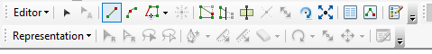
I am going to resize a shape file in only one dimension in ArcMap 10.5.1 and learned that it could be done using the Representation tool. However, when I start editing the shape file and select its features, all options under the Representation tool are grayed out (as shown below). I was wondering if there is any other way to resize in one dimension or how I could enable Representation tool options?
I would greatly appreciate your help!
Solved! Go to Solution.
Accepted Solutions
- Mark as New
- Bookmark
- Subscribe
- Mute
- Subscribe to RSS Feed
- Permalink
Masih,
You need to perform a spatial adjustment or re-project the digitized data to the correct coordinate system. Take a look at About spatial adjustment—Help | ArcGIS Desktop or Project—Help | ArcGIS Desktop accordingly. Spatial adjustment tool shifts the feature data using control points between the two systems. The project tool would be used to change the digitized data from one coordinate system (the physical map) to another (your needed coordinate system). I would try and re-project first, if you know the map coordinate system.
- Mark as New
- Bookmark
- Subscribe
- Mute
- Subscribe to RSS Feed
- Permalink
If I remember correctly, the data for the representation tool must be contained in a geodatabase and will not work on shapefiles. Take a look at A quick tour of representations—Help | ArcGIS Desktop
The tools may be disabled if one of the follow is true.
- You are in an edit session.
- You are unable to obtain a schema lock. Ensure that the layer is not currently being accessed by ArcCatalog or by another ArcMap session.
- The layer is currently symbolized with a feature class representation.
- The layer's data source is not a point, line, or polygon feature class in a geodatabase. Shapefiles, coverages, annotation feature classes, and dimension feature classes cannot support feature class representations.
- The layer is currently symbolized with the proportional symbol, the quantity by category, or one of the chart symbol categories.
- The layer's data source resides in a geodatabase that has not yet been upgraded to the current release.
- You are using ArcGIS Desktop Basic. An ArcGIS Desktop Standard or Desktop Advanced license is required to create representations.
- Mark as New
- Bookmark
- Subscribe
- Mute
- Subscribe to RSS Feed
- Permalink
Thank you Lance for the information! So there is no way to resize a shapefile in one dimension then?
- Mark as New
- Bookmark
- Subscribe
- Mute
- Subscribe to RSS Feed
- Permalink
Masih,
Can you please clarify what you meant by "resize a shapefile"? Are you in reference to the georeferencing of the entire shapefile or scaling the individual features in the shapefile?
- Mark as New
- Bookmark
- Subscribe
- Mute
- Subscribe to RSS Feed
- Permalink
Lance,
I have a shapefile that has been digitized based on a map with a wrong georeference. Now, the sizing of the shapefile on the North-South dimension is correct, but it is stretched on the East-West dimension. I was wondering if I could resize/decrease its length only on the East-West dimension?
- Mark as New
- Bookmark
- Subscribe
- Mute
- Subscribe to RSS Feed
- Permalink
Masih,
You need to perform a spatial adjustment or re-project the digitized data to the correct coordinate system. Take a look at About spatial adjustment—Help | ArcGIS Desktop or Project—Help | ArcGIS Desktop accordingly. Spatial adjustment tool shifts the feature data using control points between the two systems. The project tool would be used to change the digitized data from one coordinate system (the physical map) to another (your needed coordinate system). I would try and re-project first, if you know the map coordinate system.
- Mark as New
- Bookmark
- Subscribe
- Mute
- Subscribe to RSS Feed
- Permalink
Lance,
Thank you very much! problem resolved now. 
- Mark as New
- Bookmark
- Subscribe
- Mute
- Subscribe to RSS Feed
- Permalink
If one of Lance’s answers helped you resolve your issue, please mark the answer as correct. Thank you.
- Mark as New
- Bookmark
- Subscribe
- Mute
- Subscribe to RSS Feed
- Permalink
Done. Thanks for the suggestion!