Turn on suggestions
Auto-suggest helps you quickly narrow down your search results by suggesting possible matches as you type.
Cancel
- Home
- :
- All Communities
- :
- Products
- :
- Data Management
- :
- Data Management Questions
- :
- "Null z value/empty geometry" error when reconcili...
Options
- Subscribe to RSS Feed
- Mark Topic as New
- Mark Topic as Read
- Float this Topic for Current User
- Bookmark
- Subscribe
- Mute
- Printer Friendly Page
"Null z value/empty geometry" error when reconciling
Subscribe
6902
14
03-15-2011 07:13 AM
03-15-2011
07:13 AM
- Mark as New
- Bookmark
- Subscribe
- Mute
- Subscribe to RSS Feed
- Permalink
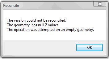
Our shop of 6 editors on a versioned SDE instance on a SQL Server 2005 database has been increasingly running into times when reconciling fails and getting a "null Z values/empty geometry" error message (screen shot attached). Up until today, it's happened on small edits so it's been easier to just delete the version and redo the edit than to try and track down the problem. But now I've run a process that took all weekend and come back to find this error when I tried to reconcile the version containing the results.
It occurred to me recently that I believe that this started happening only after we put our parcel fabric into production in this same geodatabase. Since I think the fabric is the only feature class that we have that's Z-aware, this makes some sense. Anyone else have any experience with this? Regardless of the cause, is there a way to fix this?
Thanks,
Dan
14 Replies
09-15-2011
04:32 AM
- Mark as New
- Bookmark
- Subscribe
- Mute
- Subscribe to RSS Feed
- Permalink
Dan,
Thanks for the response. We are having similiar issues with getting a GDB backup to tech support. Tell me how you address the issues you are having. Do you delete the null features and then are able to reconcile and post without issues? How do you find the problems you are having? Is there an automated process you have found that can eliminate the errors? Thanks again for your help!
Thanks for the response. We are having similiar issues with getting a GDB backup to tech support. Tell me how you address the issues you are having. Do you delete the null features and then are able to reconcile and post without issues? How do you find the problems you are having? Is there an automated process you have found that can eliminate the errors? Thanks again for your help!
09-15-2011
06:22 AM
- Mark as New
- Bookmark
- Subscribe
- Mute
- Subscribe to RSS Feed
- Permalink
Nothing has seemed to allow us to reconcile a version once we get errors of this type. We've always had to delete the version (abandoning all the edits therein) and redo our work. The silver lining to that cloud is that it's conditioned all our editors to be diligent about reconciling/posting.
We have one editor in particular who gets stuff that truly doesn't make any sense--she has no permissions to edit our parcel fabric, yet she gets errors regarding that parcel fabric. John, do you have a parcel fabric in the SDE instance where you're getting your reconcile errors?
We have one editor in particular who gets stuff that truly doesn't make any sense--she has no permissions to edit our parcel fabric, yet she gets errors regarding that parcel fabric. John, do you have a parcel fabric in the SDE instance where you're getting your reconcile errors?
09-16-2011
11:59 AM
- Mark as New
- Bookmark
- Subscribe
- Mute
- Subscribe to RSS Feed
- Permalink
Dan,
We are using a parcel fabric in SDE. It is a pilot test right now. I just spoke with one of the developers and it appears that what we thought was a null geometry was really just a radial line. These have a shape.len = 0 and a category = 4. Would be nice to hear about how you guys are doing on using the fabric. We are trying to translate our workflows now. Have any tips? Thanks.
We are using a parcel fabric in SDE. It is a pilot test right now. I just spoke with one of the developers and it appears that what we thought was a null geometry was really just a radial line. These have a shape.len = 0 and a category = 4. Would be nice to hear about how you guys are doing on using the fabric. We are trying to translate our workflows now. Have any tips? Thanks.
09-16-2011
01:52 PM
- Mark as New
- Bookmark
- Subscribe
- Mute
- Subscribe to RSS Feed
- Permalink
We jumped on board the parcel fabric bus shortly after ESRI started driving it. Our early entry got us some personal attention from ESRI, but it also got us involved in the early attempts to import "legacy" data into a fabric. Our import lacked a lot, and we're still paying some price for that--a lot of bad parcel dimensions & geometries got imported or created. We could have re-imported later, but we figured that would have been more painful than dealing with the stuff we had. Those bad dimensions hide undetected until one of those parcels gets taken into a job, then when the job is finished & parcels are re-joined, ArcMap tries to draw the parcel based on those wacky dimensions and all hell breaks loose, cartographically speaking. I think the import has improved significantly since those days "way back" in 2008, so this may not be an issue for you. Another issue that we've had is that we haven't yet been able to run a LSA successfully on our data. I can create a fabric & make some simple parcels, then run an LSA on them successfully. But even after double- & triple- & quadruple-checking all dimensions in several neighborhoods in our production data to make sure we had all record dimensions, LSAs failed in those neighborhoods regardless of what kinds of tolerances I used. It was probably a year ago that I last attempted an LSA. Maybe our fabric's hosed up as a result of those import issues, maybe the LSA logic needed tweaking, maybe I was doing something wrong, and definitely our control sucks right out the door in a couple areas. I have a feeling that, despite the ability for the fabric to hold dimensions measured in the 1890s, the fabric was designed with the assumption that everything in our parcel map was surveyed since 1985. Regardless of the reasons for the LSAs not working, I got tired of ramming my head into a wall and I gave up & devoted my efforts to things that had a chance of succeeding.
Bottom line: the fabric works well enough for us to take care of day-to-day parcel maintenance (splits, combinations, subdivisions) and our editors are pretty self-sufficient. But lots of the swanky things that made me jump at the fabric (mostly LSAs) haven't come to fruition for us yet, and the less time I spend talking about it the less money I spend on gin.
PS. Expect a thank you card from the folks at the Tanqueray distillery.
11-08-2011
08:14 AM
- Mark as New
- Bookmark
- Subscribe
- Mute
- Subscribe to RSS Feed
- Permalink
Upgrade the Parcel Fabric and disable z values in the environments settings of the upgrade tool.
Upgrade Parcel Fabric: http://help.arcgis.com/en/arcgisdesk...0009000000.htm
Upgrade Parcel Fabric: http://help.arcgis.com/en/arcgisdesk...0009000000.htm
- « Previous
-
- 1
- 2
- Next »
- « Previous
-
- 1
- 2
- Next »