Turn on suggestions
Auto-suggest helps you quickly narrow down your search results by suggesting possible matches as you type.
Cancel
- Home
- :
- All Communities
- :
- Products
- :
- Data Management
- :
- Data Management Questions
- :
- Problems with black overlap while mosaicking satel...
Options
- Subscribe to RSS Feed
- Mark Topic as New
- Mark Topic as Read
- Float this Topic for Current User
- Bookmark
- Subscribe
- Mute
- Printer Friendly Page
Problems with black overlap while mosaicking satelite images
Subscribe
12583
12
04-10-2012 12:58 PM
by
Anonymous User
Not applicable
04-10-2012
12:58 PM
- Mark as New
- Bookmark
- Subscribe
- Mute
- Subscribe to RSS Feed
- Permalink
Original User: grastafaram
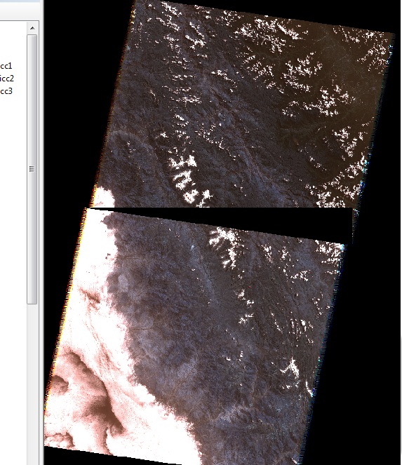
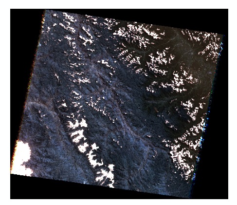
Hi, I am attempting to mosaic two Landsat 5 images taken from the USGS GLOVIS site. The images come as a tilted rectangular image inside a black rectangle, I have attached a screen shot of one image. When trying to mosaic the images together, the black portion of the rectangle covers a portion of the upper image, as shown in the second screen shot attached. Is there a way to mosaic the images together without having the black band cover the actual image?
Some info about the images - the images have the same spatial reference, 7 bands, Pixel type: unsigned integer, Pixel depth: 16 Bit, Pyramids: Level 5, nearest neighbor.
Any help is greatly appreciated.
Thanks,
Graham
12 Replies
by
Anonymous User
Not applicable
04-30-2012
02:37 PM
- Mark as New
- Bookmark
- Subscribe
- Mute
- Subscribe to RSS Feed
- Permalink
Original User: Tarun_Jaiswal
Hi Todd,
Patrick is referring to a Mosaic Dataset. Which is a new Raster Model in ArcGIS 10. To create or edit a mosaic dataset requires an ArcEditor or ArcInfo license.
Thank you.
How would one attempt this in 9.3 ?
Thank you for the help in advance!
Todd
Hi Todd,
Patrick is referring to a Mosaic Dataset. Which is a new Raster Model in ArcGIS 10. To create or edit a mosaic dataset requires an ArcEditor or ArcInfo license.
Thank you.
05-03-2012
07:34 AM
- Mark as New
- Bookmark
- Subscribe
- Mute
- Subscribe to RSS Feed
- Permalink
Hi Todd,
Patrick is referring to a Mosaic Dataset. Which is a new Raster Model in ArcGIS 10. To create or edit a mosaic dataset requires an ArcEditor or ArcInfo license.
Thank you.
Thank you Much Tarun!
by
Anonymous User
Not applicable
05-09-2012
10:31 AM
- Mark as New
- Bookmark
- Subscribe
- Mute
- Subscribe to RSS Feed
- Permalink
Original User: Trenah
Sorry for such a late reply...Thank you very much Mr. Gamble!! Greatly appreciated!
Sorry for such a late reply...Thank you very much Mr. Gamble!! Greatly appreciated!
- « Previous
-
- 1
- 2
- Next »
- « Previous
-
- 1
- 2
- Next »