- Home
- :
- All Communities
- :
- Products
- :
- Data Management
- :
- Data Management Questions
- :
- Re: Pixel depth problem Mosaic Dataset Analyzer: E...
- Subscribe to RSS Feed
- Mark Topic as New
- Mark Topic as Read
- Float this Topic for Current User
- Bookmark
- Subscribe
- Mute
- Printer Friendly Page
Pixel depth problem Mosaic Dataset Analyzer: Error 70127
- Mark as New
- Bookmark
- Subscribe
- Mute
- Subscribe to RSS Feed
- Permalink
I have a MD that is giving me this error when analyzed
"The pixel type of the raster associated with the mosaic dataset item indicates that pixel values might be outside of the range allowed by the mosaic dataset."
The thing I do not get is that the MD is set to the same pixel depth as the source rasters? I do have a function applied to change meters to feet...
MD properties
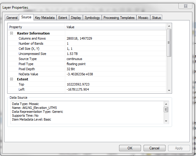
I don't understand why this error is showing up...
Solved! Go to Solution.
Accepted Solutions
- Mark as New
- Bookmark
- Subscribe
- Mute
- Subscribe to RSS Feed
- Permalink
Forest,
Did you change the output pixel type of the function you used to match your mosaic dataset's pixel type? What function you use matters less than setting the right output pixel type. That is what is causing the analyzer to throw the error.
-Prashant
- Mark as New
- Bookmark
- Subscribe
- Mute
- Subscribe to RSS Feed
- Permalink
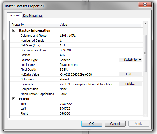
I am sure it is nothing, but the nodata value is ever so slightly different and the 'edit' option appears in the latter. I presume the elevations are in keeping with other values even when converted to feet? and does it work without the function applied?
- Mark as New
- Bookmark
- Subscribe
- Mute
- Subscribe to RSS Feed
- Permalink
Ya, it is weird. I was thinking that in theory one could have a "large" 32bit float then when one divides by .3048 to go from meters to feet (the function) the output could be larger then then the 32bit float container. But even when I set the pixel depth to 64bit it still does shows the error. The data in the MD looks fine however. I don't know. I want to just ignore it. But I am having some problems getting this MD to work so I am trying to track down all errors.
- Mark as New
- Bookmark
- Subscribe
- Mute
- Subscribe to RSS Feed
- Permalink
I don't think those elevations  Single-precision_floating-point_format
- Mark as New
- Bookmark
- Subscribe
- Mute
- Subscribe to RSS Feed
- Permalink
Right, my elevation values are always going to be fine in a 32bit floating point. But arc may not be looking at what the values are. But just at the range of possible values.If this is the case I think esri should think about demoting this issue from a error to a warning.
Also the error is gone if I remove the function.
- Mark as New
- Bookmark
- Subscribe
- Mute
- Subscribe to RSS Feed
- Permalink
Which makes it stranger since the raster function list here applies to rasters and mosaic datasets, so one would presume an Arithmetic multiplication would not upscale the result. What about Unit Conversion?
- Mark as New
- Bookmark
- Subscribe
- Mute
- Subscribe to RSS Feed
- Permalink
Same error.
- Mark as New
- Bookmark
- Subscribe
- Mute
- Subscribe to RSS Feed
- Permalink
I give up... meters are better anyway I would pass this on to tech support, since no one else monitoring the thread has any ideas to share either
- Mark as New
- Bookmark
- Subscribe
- Mute
- Subscribe to RSS Feed
- Permalink
Hahaha, sure they are. Project requirement is for feet. My source rasters are mixed units in the vertical so I will have to covert no mater what....
I may call ersi next week on it... Who knows maybe an esri person will see this post Monday.