- Home
- :
- All Communities
- :
- Products
- :
- Data Management
- :
- Data Management Questions
- :
- Overlaying
- Subscribe to RSS Feed
- Mark Topic as New
- Mark Topic as Read
- Float this Topic for Current User
- Bookmark
- Subscribe
- Mute
- Printer Friendly Page
Overlaying
- Mark as New
- Bookmark
- Subscribe
- Mute
- Subscribe to RSS Feed
- Permalink
Hi please help me it is very urgent...i have a vector data of 1:25000 which was digitized and the raster is of 1:50000...so now i wan the vector data to aligned with the toposheet of 1:50000 as their is a shift when i overlay the vector data on 1:50000 toposheet..how can it be done so that the vector data is aligned on 1:50000 toposheet..please help me..thank youw

- Mark as New
- Bookmark
- Subscribe
- Mute
- Subscribe to RSS Feed
- Permalink
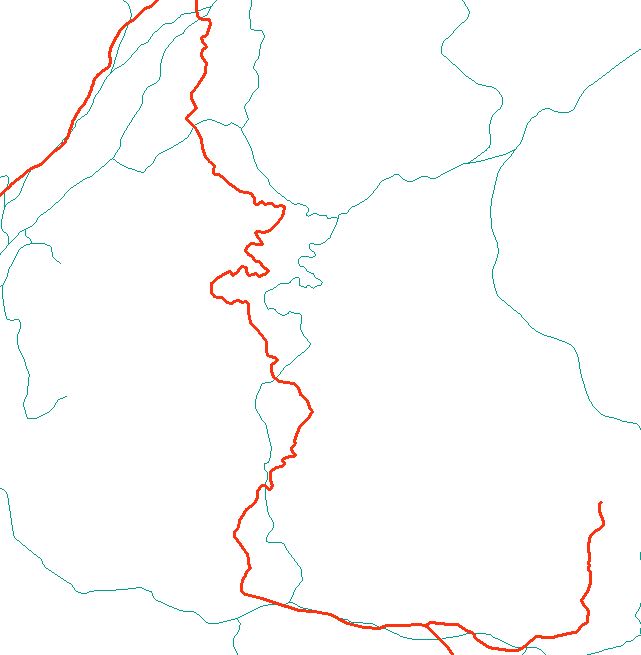
How were these created? was CAD involved? they look slightly rotated and scaled. This isn't just a coordinate system issue and I doubt they will ever match perfectly or even close since, although there are similarities, the differences between them is great. I would pick the one that matches the imagery ... if one does ... and use it. If the digitizing was done of the image, its coordinate system would need to be known in the event that the coordinate system of the vectors used it
- Mark as New
- Bookmark
- Subscribe
- Mute
- Subscribe to RSS Feed
- Permalink
the green line was digitized of different scale i guess cause i just got the data from a friend whereas the red line s from field survey so inorder to save time i ask from my friend since all the data s there so i dont need to go to the field anymore
- Mark as New
- Bookmark
- Subscribe
- Mute
- Subscribe to RSS Feed
- Permalink
so thats why i wana know if theres any method to get the data correct
- Mark as New
- Bookmark
- Subscribe
- Mute
- Subscribe to RSS Feed
- Permalink
trying to use spatial adjustment but I suspect that the number of links needed between the two may be too many and the results less than satisfactory. You could give it a try, or if you are just trying to show additions or removals or small changes in the network, it might be faster to just do those to a copy of the 'best' one that you have. Give it a try first
- Mark as New
- Bookmark
- Subscribe
- Mute
- Subscribe to RSS Feed
- Permalink
ok il try..thank you
- Mark as New
- Bookmark
- Subscribe
- Mute
- Subscribe to RSS Feed
- Permalink
Considering both the vector data and the toposheet are in same coordinate system,
1) If the shift is uniform, you may like to select all features and use Move tool from Editor Toolbar Moving a feature by dragging it
2) If the shift is non-uniform, you may like to use Spatial Adjustment toolbar. About Spatial Adjustment
Think Location
- « Previous
-
- 1
- 2
- Next »
- « Previous
-
- 1
- 2
- Next »