Turn on suggestions
Auto-suggest helps you quickly narrow down your search results by suggesting possible matches as you type.
Cancel
- Home
- :
- All Communities
- :
- Products
- :
- Data Management
- :
- Data Management Questions
- :
- Need to convert raster elevation data to polygons
Options
- Subscribe to RSS Feed
- Mark Topic as New
- Mark Topic as Read
- Float this Topic for Current User
- Bookmark
- Subscribe
- Mute
- Printer Friendly Page
Need to convert raster elevation data to polygons
Subscribe
04-14-2013
09:42 AM
- Mark as New
- Bookmark
- Subscribe
- Mute
- Subscribe to RSS Feed
- Permalink
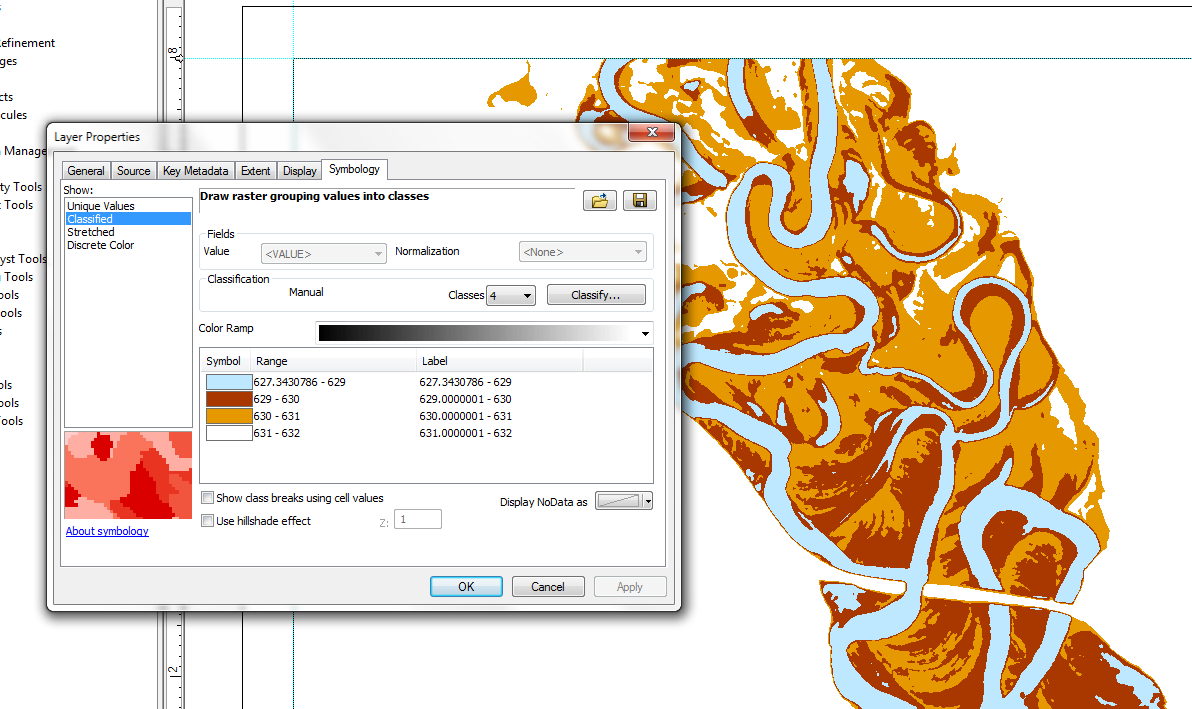
I have a data set that I downloaded from the national elevation data set (NED). The data is for a river meander reach. Is there a way that I can convert the raster data to polygons, consistent with the way in which I have symbolized the data in the attached example? The data is symbolized based on elevation ranges (z values) shown in the dialogue box.
[ATTACH=CONFIG]23477[/ATTACH]
[ATTACH=CONFIG]23477[/ATTACH]
Solved! Go to Solution.
1 Solution
Accepted Solutions
04-15-2013
09:01 AM
- Mark as New
- Bookmark
- Subscribe
- Mute
- Subscribe to RSS Feed
- Permalink
Reclassify comes first since it will result in an integer raster, then convert to polygons. You can't convert floating point rasters into polygons.
Best,
Eric
Best,
Eric
2 Replies
04-14-2013
06:07 PM
- Mark as New
- Bookmark
- Subscribe
- Mute
- Subscribe to RSS Feed
- Permalink
You probably need to do a Polygon to Raster:
http://resources.arcgis.com/en/help/main/10.1/index.html#//001200000030000000
Followed by a Reclass:
http://resources.arcgis.com/en/help/main/10.1/index.html#//009z000000sr000000
Licensing would require Spatial Analyst or 3D Analyst.
http://resources.arcgis.com/en/help/main/10.1/index.html#//001200000030000000
Followed by a Reclass:
http://resources.arcgis.com/en/help/main/10.1/index.html#//009z000000sr000000
Licensing would require Spatial Analyst or 3D Analyst.
04-15-2013
09:01 AM
- Mark as New
- Bookmark
- Subscribe
- Mute
- Subscribe to RSS Feed
- Permalink
Reclassify comes first since it will result in an integer raster, then convert to polygons. You can't convert floating point rasters into polygons.
Best,
Eric
Best,
Eric