Turn on suggestions
Auto-suggest helps you quickly narrow down your search results by suggesting possible matches as you type.
Cancel
- Home
- :
- All Communities
- :
- Products
- :
- Data Management
- :
- Data Management Questions
- :
- Re: Mapping drainage ditches in DEM
Options
- Subscribe to RSS Feed
- Mark Topic as New
- Mark Topic as Read
- Float this Topic for Current User
- Bookmark
- Subscribe
- Mute
- Printer Friendly Page
Mapping drainage ditches in DEM
Subscribe
5267
6
10-10-2013 02:31 AM
10-10-2013
02:31 AM
- Mark as New
- Bookmark
- Subscribe
- Mute
- Subscribe to RSS Feed
- Permalink
Hello,
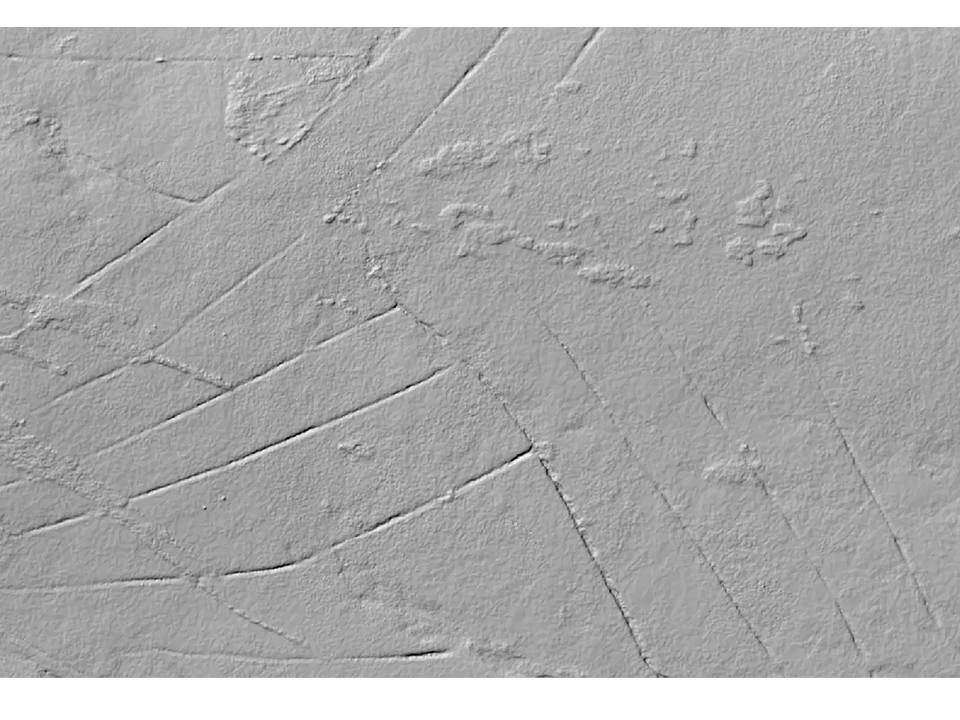
I've been looking into ways of automated mapping of drainage ditches from a DEM (The straight line features in the attachment).
I've been getting some decent results using the Hydrology tools in the Spatial Analyst extension.
What i was hoping for some help with is if someone knows any other way to do this using the DEM?
Another thing i would like to try is to somehow automatically calculate the widths and/or depths of the drainage ditches.
Any ideas? I've been looking into creating cross sections but was wondering if there was another way that I'm not aware of?
Thanks for any help.
6 Replies
10-10-2013
07:02 AM
- Mark as New
- Bookmark
- Subscribe
- Mute
- Subscribe to RSS Feed
- Permalink
Depending on your license level (this toolset requires advanced license I believe) you could have a look at Arc Hydro.
Regards,
Jim
Regards,
Jim
10-10-2013
07:47 AM
- Mark as New
- Bookmark
- Subscribe
- Mute
- Subscribe to RSS Feed
- Permalink
Thanks Jim. Actually I've just downloaded ArcHydro and TauDEM.
Are there any specific tools you would recommend.
I've created a decent stream network using spatial analyst.
What I would like to do now is somehow figure out the width of the drainage ditch from the DEM.
Are there any specific tools you would recommend.
I've created a decent stream network using spatial analyst.
What I would like to do now is somehow figure out the width of the drainage ditch from the DEM.
10-10-2013
01:37 PM
- Mark as New
- Bookmark
- Subscribe
- Mute
- Subscribe to RSS Feed
- Permalink
Mark,
Afraid I do not have a solution for that one.
Jim
Afraid I do not have a solution for that one.
Jim
10-11-2013
01:00 AM
- Mark as New
- Bookmark
- Subscribe
- Mute
- Subscribe to RSS Feed
- Permalink
Thanks anyway Jim. I have a feeling I may be asking for the impossible!
10-14-2013
11:06 AM
- Mark as New
- Bookmark
- Subscribe
- Mute
- Subscribe to RSS Feed
- Permalink
Hello,
What i was hoping for some help with is if someone knows any other way to do this using the DEM?
Another thing i would like to try is to somehow automatically calculate the widths and/or depths of the drainage ditches.
Mark - based on the DEM example you provided, I think the best you'll be able to do is manually measure a few transects across each ditch to sample the ditch at appropriate points -- and you'll have to decide where the appropriate points are. This appears to be a DSM (including trees & vegetation) or if it's a "bare earth" DEM, then the processing and resolution aren't adequate to do what you're seeking. Any hydro tool will show your water flow stopping at the apparent high points in the ditches (where I believe there is vegetation overhanging the ditch, so the water channel doesn't *appear* to be unobstructed).
If you're seeking a tool to automatically estimate the MAXIMUM width and depth as transects across a linear feature representing the ditch (where the first step is to generate that linear feature), that should be possible, but a mapping of the width & depth of the full extent of the ditches won't be possible (my opinion) given the resolution and processing of your current data.
I hope that is helpful -
Cody Benkelman
10-15-2013
03:57 AM
- Mark as New
- Bookmark
- Subscribe
- Mute
- Subscribe to RSS Feed
- Permalink
Hello Cody. Thank you for your reply. Yes you are right it is a DSM. I've created a stream network using the hydrology tools in spatial analyst but like you say the flow stops at certain points in ditchs or flows off in another direction. The best I can think to do now is to manually digitise or extensively edit the stream network.
I've had a look at transects as you suggested. I've just been using the 'Interpolate Line' and 'Profile Graph' functions in the 3D analyst toolbar. However I can't really do much with the data from the graph as it appears to only create a graphic file. Are there any other tools you would suggest to use. How would you automatically calculate the maximum width and depth?
Thanks for your help