- Home
- :
- All Communities
- :
- Products
- :
- Data Management
- :
- Data Management Questions
- :
- Looking for South Sudan shapefile with 28 states.....
- Subscribe to RSS Feed
- Mark Topic as New
- Mark Topic as Read
- Float this Topic for Current User
- Bookmark
- Subscribe
- Mute
- Printer Friendly Page
Looking for South Sudan shapefile with 28 states...
- Mark as New
- Bookmark
- Subscribe
- Mute
- Subscribe to RSS Feed
- Permalink
Hi all,
I am looking for a shapefile/esri geodatabase with the 28 newly formed states of South Sudan (since 2015 South Sudan consist of 28 instead of 10 states). And preferably even a shapefile with the 180 counties, but that might be a bridge too far...
Anyone who can help me out?
Thanks a lot, Linda
- Mark as New
- Bookmark
- Subscribe
- Mute
- Subscribe to RSS Feed
- Permalink
Thanks a lot, but I already tried both websites. They both have the 10 outdated states, not the new 28 states. It seems a complete transformation in the administrative system of South Sudan goes unnoticed by the rest of the world... States of South Sudan - Wikipedia . Any other suggestions where to try?
- Mark as New
- Bookmark
- Subscribe
- Mute
- Subscribe to RSS Feed
- Permalink
I've searched for those boundaries and can't find any official reference to them. They might have been revised again. Have a look at the boundaries provided by the UN OCHA here: South Sudan - Administrative Boundaries - Humanitarian Data Exchange
- Mark as New
- Bookmark
- Subscribe
- Mute
- Subscribe to RSS Feed
- Permalink
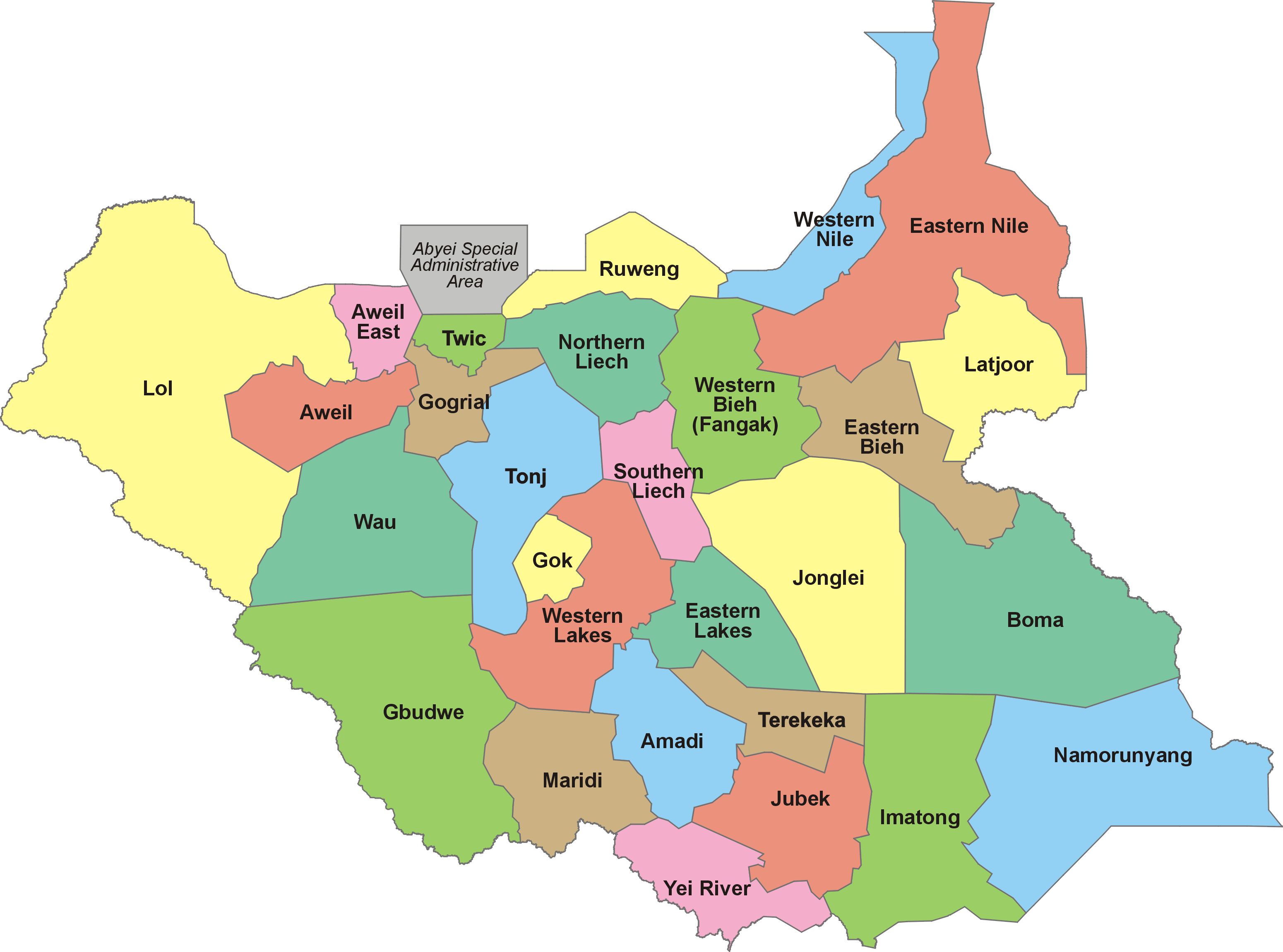
https://upload.wikimedia.org/wikipedia/commons/b/b0/28_States_of_South_Sudan.png
I can see this image from Wikipedia. Maybe you could geo-reference the image and digitize the boundaries.
Think Location
- Mark as New
- Bookmark
- Subscribe
- Mute
- Subscribe to RSS Feed
- Permalink
Thanks all for your help. I managed to georeference the image and digitize the boundaries, as for a lot of the new states the fromer county borders were used. However, it stays interesting that no maps with 28 states seem to exist  . Is that because even the Sudanese government doesn't believe in it? Thank you all, linda
- Mark as New
- Bookmark
- Subscribe
- Mute
- Subscribe to RSS Feed
- Permalink
Hello Linda,
Any chance you are willing to share your South Sudan border files?
Have you updated them to 32 states yet?
Thanks,
- Mark as New
- Bookmark
- Subscribe
- Mute
- Subscribe to RSS Feed
- Permalink
I am also interested in this updated shapefile, thank you.