Turn on suggestions
Auto-suggest helps you quickly narrow down your search results by suggesting possible matches as you type.
Cancel
- Home
- :
- All Communities
- :
- Products
- :
- Data Management
- :
- Data Management Questions
- :
- Line with a specific length
Options
- Subscribe to RSS Feed
- Mark Topic as New
- Mark Topic as Read
- Float this Topic for Current User
- Bookmark
- Subscribe
- Mute
- Printer Friendly Page
Line with a specific length
Subscribe
7499
3
05-17-2011 02:19 PM
05-17-2011
02:19 PM
- Mark as New
- Bookmark
- Subscribe
- Mute
- Subscribe to RSS Feed
- Permalink
Hello all,
I'm a new ArcGIS user and struggling here, I've been a CAD user for almost 5 years now.
I know that ArcGIS can draw a line by a length, but something has to be wrong.
I start the line click Ctrl+L and nothing happends. I right click and I get no options.
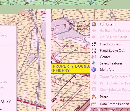
I've attached a photo of the menu I get when right clicking with the line tool activated.
Can somebody please shed some light on my problem?
Thanks,
dsm-dude
I'm a new ArcGIS user and struggling here, I've been a CAD user for almost 5 years now.
I know that ArcGIS can draw a line by a length, but something has to be wrong.
I start the line click Ctrl+L and nothing happends. I right click and I get no options.
I've attached a photo of the menu I get when right clicking with the line tool activated.
Can somebody please shed some light on my problem?
Thanks,
dsm-dude
3 Replies
05-18-2011
10:52 PM
- Mark as New
- Bookmark
- Subscribe
- Mute
- Subscribe to RSS Feed
- Permalink
Hi dsm-dude,
your screenshot shows me that you are not in an Edit session - therefor you can´t digitize a line. If you open an Edit session you will get this menu, please see attached screenshot menu_1.
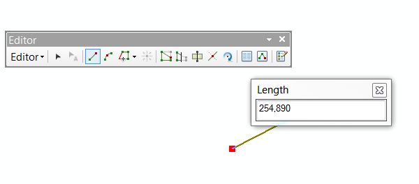
I tried to reproduce your problem of not getting a menu while digitizing a line...I am using ArcGIS 10. I started to digitize a line, pushed CTRL+L and I could specify a length. Yes, you are right - as long as I didn´t close the Length field (see attached screenshot Length), a menu will not pop up.
If you still have the problem, I would suggest to contact your support.
I hope I could shed some light,
Anna
Anna Schwabedal
_______________
Product Marketing
Esri Germany
your screenshot shows me that you are not in an Edit session - therefor you can´t digitize a line. If you open an Edit session you will get this menu, please see attached screenshot menu_1.
I tried to reproduce your problem of not getting a menu while digitizing a line...I am using ArcGIS 10. I started to digitize a line, pushed CTRL+L and I could specify a length. Yes, you are right - as long as I didn´t close the Length field (see attached screenshot Length), a menu will not pop up.
If you still have the problem, I would suggest to contact your support.
I hope I could shed some light,
Anna
Anna Schwabedal
_______________
Product Marketing
Esri Germany
06-07-2011
07:08 AM
- Mark as New
- Bookmark
- Subscribe
- Mute
- Subscribe to RSS Feed
- Permalink
dsm-dude,
I was once an AutoCAD and Microstation draftsman for over seven years before I switched to ArcGIS 8.0 years ago. I worked a lot of the tutorials before I finally switch from drafting to analysis mode. It took me a little bit to understand that data and layout views were similar to workspace and paper space along with the little things that make editing difficult at first.
Hang in there and ArcGIS 10 has finally demonstrated some CAD editing techniques like the advanced snapping that former CAD users have needed for a long time.
If you have any more questions, keep posting and the ArcGIS community will keep pointing you in the right direction.
Bethany Hall
GIS Ninja
GIS Ninja