- Home
- :
- All Communities
- :
- Products
- :
- Data Management
- :
- Data Management Questions
- :
- how to geocode lines
- Subscribe to RSS Feed
- Mark Topic as New
- Mark Topic as Read
- Float this Topic for Current User
- Bookmark
- Subscribe
- Mute
- Printer Friendly Page
how to geocode lines
- Mark as New
- Bookmark
- Subscribe
- Mute
- Subscribe to RSS Feed
- Permalink
I want to geocode bike routes on the map. Now I have created an excel sheet containing information about primary road, cross intersection 1 (start point) and cross intersection 2(end point). There are about 300 records need to be geocoded, and I really don't want to draw them manually...
Attempts have been made to create route layers by using Network Analyst, but I don't have that extension available on my computer. Is there any other way to geocode lines?
I really appreciate it if someone could shed some light on this question.
- Mark as New
- Bookmark
- Subscribe
- Mute
- Subscribe to RSS Feed
- Permalink
I used LACounty CAMS address locator to geocode all my intersections. How to connect all the start and end points though?
- Mark as New
- Bookmark
- Subscribe
- Mute
- Subscribe to RSS Feed
- Permalink
Linear Referencing creates points with two fields holding a Route ID (that uniquely references a feature class with polylines that contain Route IDs and measures or M values in the geometry) and a single measure (a station) and creates line segments with 3 fields holding a Route ID and two measures.
The Locate Features Along Route tool can determine the Route ID and measure of a point feature class that is created using geocoding and output a table containing the Route ID and measure of the point. Run this tool twice, once with the geocoded From point and once with the geocoded To point. The From and To points should already have the same Bike Lane Segment ID associated with them before doing this and there should be two points with the same bike lane segment ID. The points should also have the intersection name field.
Uncheck the match only closest route option when running the Locate Features Along Route tool when doing this, since you can select the true matches based on the street the bike lane segment is supposed to be on and export that set to eliminate false matches.
Now since the two table have the same bike lane segment ID (your From and To points), join the two tables on that ID and export the table. Now you have a single table that has a Route ID and two measures (a From Measure and a To measure) and you can use it to create a bike lane segment with the feature class that contains Route IDs and measures or M values in the geometry by using the Make Route Event Layer tool.
- Mark as New
- Bookmark
- Subscribe
- Mute
- Subscribe to RSS Feed
- Permalink
Hi Richard,
this is a dope! Thanks for your time and help.
- Mark as New
- Bookmark
- Subscribe
- Mute
- Subscribe to RSS Feed
- Permalink
Hi Richard,
The result come out. I tested 145 records and find 87 of them was able to be geocoded. The 87 records are geocoded accurately, but the rest of them can't be geocoded. I am trying to improve accuracy, but overall this is a very good sign.
- Mark as New
- Bookmark
- Subscribe
- Mute
- Subscribe to RSS Feed
- Permalink
As mentioned, you will need to acquire a street centerlines feature class and perform some sort of overlay process with the points you got back from geocoding and the centerlines.
- Mark as New
- Bookmark
- Subscribe
- Mute
- Subscribe to RSS Feed
- Permalink
Hi,
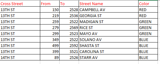
I have a very similar problem at hand, for mapping boundaries of police beat or fire districts. As shown in the image below, I am trying to draw a polygon or at least lines for the addresses/parcels between 'From' and 'Two' and give them individual color. I can geocode them but then all I'll have are points. How do I go from geocoding points to lines or even better polygons layers? Any feedback will be greatly appreciated - Richard Fairhurst and Joe Borgione.
Thanks,
Shital
- Mark as New
- Bookmark
- Subscribe
- Mute
- Subscribe to RSS Feed
- Permalink
If you have an advanced license you can use create polygons from your points. See : How To: Create polygons from points in ArcGIS Pro
That said, you need to create a set of points that mark the vertices of you polygons which I guess are hidden in the table you provide. Since I don't understand what your table represents, you'll need to explain it and we can go to the next step.
- Mark as New
- Bookmark
- Subscribe
- Mute
- Subscribe to RSS Feed
- Permalink
Thanks, Joe.
When I think of it more, a line layer is more feasible than a polygon.
Let me explain more. I am trying to create a street sweeping map so that each household knows what color zone they belong too. The table has a beginning and ending street intersections for each zone and the cross street that goes through the zone. There are no other vertices. So for the first column, I am trying to give the street segment between 150 to 2528 Cambell Ave a red color and street segment between 259 - 2522 Madigan St a green color. I have over 6000 such rows.
So in short, how do I join these street intersections to get a line layer? Thanks!
- Mark as New
- Bookmark
- Subscribe
- Mute
- Subscribe to RSS Feed
- Permalink
Create a table of 'addresses' for each intersection and geocode them:
150 Campbell Ave |
| 2538 Campbell Ave |
| 219 Georgia St |
| 2536 Georgia St |
| etc... |
I've not done this but once you have your points you can apply this tool Points To Line—Data Management toolbox | Documentation to them to create your lines. Emphasis on I've never done it so there may be a learning curve in the actual execution of this approach.
- Mark as New
- Bookmark
- Subscribe
- Mute
- Subscribe to RSS Feed
- Permalink
Thank you Joe but I doubt if Points to Line would be the right tool here because it would join all the points in Red Zone but in reality, there would be blocks of green and blue zone streets in between two red zones. Also, it wouldn't respect the geometry of real-life streets - they are seldom in a straight line.
I have a hunch that Linear Referencing might have the right tools for the job, need to explore more.