- Home
- :
- All Communities
- :
- Products
- :
- Data Management
- :
- Data Management Questions
- :
- Re: How to extract a single layer from a group of ...
- Subscribe to RSS Feed
- Mark Topic as New
- Mark Topic as Read
- Float this Topic for Current User
- Bookmark
- Subscribe
- Mute
- Printer Friendly Page
How to extract a single layer from a group of layer that I got from a server
- Mark as New
- Bookmark
- Subscribe
- Mute
- Subscribe to RSS Feed
- Permalink
Hello.
I am working in Arcmap and found the info I need, but it downloaded as a layer with many others imbedded into it...
I need to get ONE layer make it a raster and later a shape.
I used the Extract data, but because it is a group of layer and the title says Imagery/Elevation, I am unable to get through the step.. Also, I have no option to select the imagery alone or the elevation.
Any help will be appreciated.. I have similar problem with the street.
See layers attached..
Thank you.
C
Solved! Go to Solution.
Accepted Solutions
- Mark as New
- Bookmark
- Subscribe
- Mute
- Subscribe to RSS Feed
- Permalink
If you add the ImageryDEM layer file to you TOC, and enter the properties of the service, you will find this.
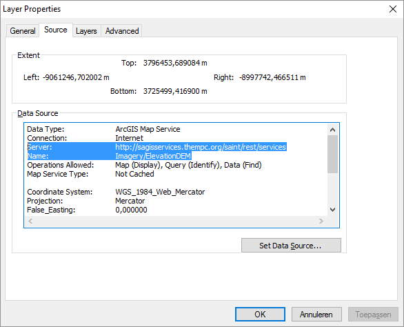
The highlighted part shows the REST URL to the service. If go to the URL:
... you will see that you loaded the MapService. What you want to use is this ImageService:
Imagery/ChathamDEM_2009 (ImageServer) ... which references the same data but now as an image service. If you connect to the server as a user like this:

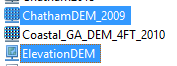
You can add the image service "ChathamDEM_2009" found in the folder Imagery. You can see it has a different icon than the ElevationDEM you used:
This layer can be used for calculations. For instance after setting the proper extent and resolution, you can apply a simple calculation with the Raster Calculation:
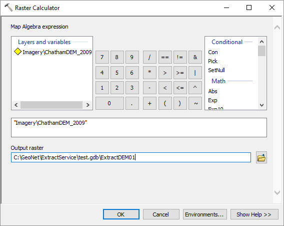
Which will create a local raster dataset you can use for anything you want.
Do check if there are any restrictions that apply to the usage of the information.
- Mark as New
- Bookmark
- Subscribe
- Mute
- Subscribe to RSS Feed
- Permalink
moved to Managing Data
- Mark as New
- Bookmark
- Subscribe
- Mute
- Subscribe to RSS Feed
- Permalink
You cannot add or remove sublayers in the map service in the table of contents.
Kindly go through the below link;
- Mark as New
- Bookmark
- Subscribe
- Mute
- Subscribe to RSS Feed
- Permalink
If you add the ImageryDEM layer file to you TOC, and enter the properties of the service, you will find this.
The highlighted part shows the REST URL to the service. If go to the URL:
... you will see that you loaded the MapService. What you want to use is this ImageService:
Imagery/ChathamDEM_2009 (ImageServer) ... which references the same data but now as an image service. If you connect to the server as a user like this:
You can add the image service "ChathamDEM_2009" found in the folder Imagery. You can see it has a different icon than the ElevationDEM you used:
This layer can be used for calculations. For instance after setting the proper extent and resolution, you can apply a simple calculation with the Raster Calculation:
Which will create a local raster dataset you can use for anything you want.
Do check if there are any restrictions that apply to the usage of the information.
- Mark as New
- Bookmark
- Subscribe
- Mute
- Subscribe to RSS Feed
- Permalink
great, Thank you so much
- Mark as New
- Bookmark
- Subscribe
- Mute
- Subscribe to RSS Feed
- Permalink
Fantastic...
Thank you So much...
excellent trick.
- Mark as New
- Bookmark
- Subscribe
- Mute
- Subscribe to RSS Feed
- Permalink
So it worked for you? If so, I'm glad and you could mark the question as answered, if not please indicate what is still missing.
- Mark as New
- Bookmark
- Subscribe
- Mute
- Subscribe to RSS Feed
- Permalink
Hi Carole Wacta , thanks for marking the correct answer, but for other users it would be easier to find the solution if you would mark the actual post that answered your question as the correct answer.
- Mark as New
- Bookmark
- Subscribe
- Mute
- Subscribe to RSS Feed
- Permalink
progress is incremental Xander ... 