- Home
- :
- All Communities
- :
- Products
- :
- Data Management
- :
- Data Management Questions
- :
- How to export calibrated Route to table
- Subscribe to RSS Feed
- Mark Topic as New
- Mark Topic as Read
- Float this Topic for Current User
- Bookmark
- Subscribe
- Mute
- Printer Friendly Page
How to export calibrated Route to table
- Mark as New
- Bookmark
- Subscribe
- Mute
- Subscribe to RSS Feed
- Permalink
Hi all,
I've got what I would imagine is a relatively unique challenge. I have a route layer that I've created and calibrated with a series of other layers. I can currently take any GPS co-ordinate and convert it to a mileage. Now what I need to do is to take this route layer and export it so that others can see it in a table format (CSV, SQL, etc).
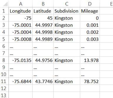
In case this sounds confusing, I'll try to explain it another way: I'm trying to take a route layer (where I can only see the mileage by using the "Identify Route Location" tool) and make it such that I can I have a table that looks like the attached table below.
I would imagine that there should be a way to simply export the route in order to do this, but any method to achieve the table below should be fine. It is important to note that I need the mileage to increase at a steady rate (ideally 0.001 miles but there is some flexibility).
I hope what I'm asking for is clear, but if not please let me know below and I will attempt to clarify  Thanks in advance!
-Zach
- Mark as New
- Bookmark
- Subscribe
- Mute
- Subscribe to RSS Feed
- Permalink
- convert the points to a polyline
- densify the polyline to your desired spacing,
- convert the densified polyline to a point file
all assumes an appropriate license level to perform the first step
- Mark as New
- Bookmark
- Subscribe
- Mute
- Subscribe to RSS Feed
- Permalink
Thanks Dan,
Any advice for if you can't convert your densified polyline to a point file? (I have a standard license, and I believe that tool requires an advanced license)
Thanks,
Zach
- Mark as New
- Bookmark
- Subscribe
- Mute
- Subscribe to RSS Feed
- Permalink
yes... but it is a workaround that I have blogged about.
FeatureClassToNumPyArray with the fields you want and the densified features exploded to points
Numpyarraytofeatureclass to get it back to a point file
But I would have done all the work in Numpy in any event
- Mark as New
- Bookmark
- Subscribe
- Mute
- Subscribe to RSS Feed
- Permalink
At my operations, we have collectors that submit data in Lat/Long from GPS, phones and other devices. I too use a linear route system, Dan Patterson (suggestion has got me intrigued never thought about doing it that way). But to get back to your question...I have a requirement that each lat/long must have a "Route" number associated to it. With that, I had to develop a program that would:
- filter my route system by the route number,
- create a point for the lat/long,
- then "SNAP" the point to the linear referencing system (Note due to filtering there would be only one line to snap too)
- then read/calculate the "Measure." (your case it would be Mileage)
I use ArcObject along with dot Net programming to accomplish this.
Although I have never tried...but theoretically you could perform all the steps manually without any special licensing....I know arc-objects honors all licensing and this bit I use that follows the above steps uses only that that is found with a standard GIS license. (If the models would accept Linear Referencing techniques like returning the measure...this could be incorporated within a model).... but alas the modeling tools do not.