- Home
- :
- All Communities
- :
- Products
- :
- Data Management
- :
- Data Management Questions
- :
- How do I export cordinates of polygon shapes to ex...
- Subscribe to RSS Feed
- Mark Topic as New
- Mark Topic as Read
- Float this Topic for Current User
- Bookmark
- Subscribe
- Mute
- Printer Friendly Page
How do I export cordinates of polygon shapes to excel.
- Mark as New
- Bookmark
- Subscribe
- Mute
- Subscribe to RSS Feed
- Permalink
I received shape files, and imported it. I can see the shapes, but I need to export the cordinate points of the shape to an excel or csv file in order to import into another program.
- Mark as New
- Bookmark
- Subscribe
- Mute
- Subscribe to RSS Feed
- Permalink
If you are looking for the XY coordinates of Centroid of polygons, you could add two Fields to Attribute Table, viz, X and Y and use Calculate Geometry to populate the fields with the X and Y coordinate of the Centroid. Then you can use Table to Excel geoprocessing tool to export to Excel.
But, if you want the XY coordinates of all the vertices of the polygon, you will need to convert feature vertices to points, add the XY fields to attribute table and populate using Calculate Geometry. Then Go for Table to Excel.
Think Location
- Mark as New
- Bookmark
- Subscribe
- Mute
- Subscribe to RSS Feed
- Permalink
For all points for all license levels, there are other workarounds
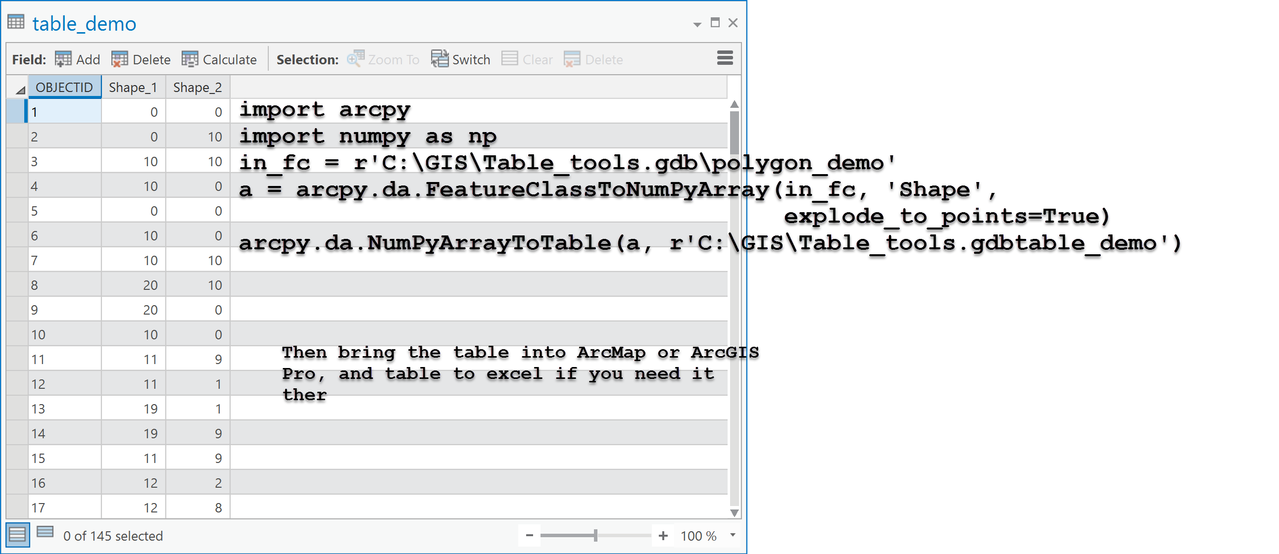
The key is the explode_to_points which busts up the geometry into its constituent points. Rows 1 to 5 form the clockwise points of a square in this example. Once busted up, bring it back in as table and export to excel, or there are tools to simply send the array to excel directly...
- Mark as New
- Bookmark
- Subscribe
- Mute
- Subscribe to RSS Feed
- Permalink
Hi Dan,
Is it possible to export the coordinates of vertices of a polygon into excel or as a text file in the following format: Polygon1: y,x ; y,x ;y,x ; y,x
Therefore, all coordinates that make up a polygon should be in one row?
- Mark as New
- Bookmark
- Subscribe
- Mute
- Subscribe to RSS Feed
- Permalink
Liesl Not without coding the output to from numpy to a row format. If you have a use case, you might want to start another question describing the need to go to excel and why WKT or similar output format is needed
- Mark as New
- Bookmark
- Subscribe
- Mute
- Subscribe to RSS Feed
- Permalink
Hi Liesl De Swardt ,
I guess you could do something like this with a bit of Python code:
def main():
import arcpy
fc = r'C:\GeoNet\WKT\data.gdb\polygons' # the input polygons
fld_id = 'OID@' # use the OID as ID field in the output
txt = r'C:\GeoNet\WKT\output2.txt' # teh output text file to load into Excel
with open(txt, 'w') as f:
with arcpy.da.SearchCursor(fc, (fld_id, 'SHAPE@')) as curs:
for row in curs:
polygon = row[1]
result = GetYXcrdList(polygon.WKT)
f.write("{}\t{}\n".format(row[0], result))
def GetYXcrdList(wkt):
wkt = wkt.replace('MULTIPOLYGON (((', '').replace(')))', '')
lst = wkt.split(',')
result = ""
for crd in lst:
xy = crd.strip().split(' ')
if result == '':
result = "{},{}".format(xy[1], xy[0])
else:
result += ";{},{}".format(xy[1], xy[0])
return result
if __name__ == '__main__':
main()
Just change:
- line 4 to point to your polygon featureclass
- line 5 to include a field to identify the resulting coordinate lists
- line 6 to point to an output text file that can be loaded into Excel
Below the result of a test run:

What do you want to do with this list of Lat, Lon coordinates in Excel?
- Mark as New
- Bookmark
- Subscribe
- Mute
- Subscribe to RSS Feed
- Permalink
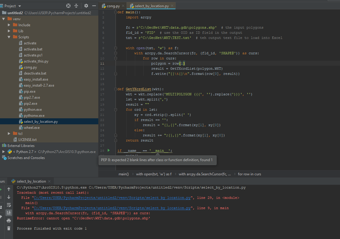
You have a shapefile in a geodatabase... try a featureclass in a geodatabase
You have to edit the full path to the inputs... you just changed "Polygons" to polygons.shp in Xander's code on line 4, so unless you recreated his folder path structure, it won't work
- Mark as New
- Bookmark
- Subscribe
- Mute
- Subscribe to RSS Feed
- Permalink
i have ald changed folder path structure , but it didn't work. .
it is my link folder , i make like him
the error still just say: "cannot open"
could you please give me an advise... thank you
- Mark as New
- Bookmark
- Subscribe
- Mute
- Subscribe to RSS Feed
- Permalink
if you can make a video for this code, it will be great....