Turn on suggestions
Auto-suggest helps you quickly narrow down your search results by suggesting possible matches as you type.
Cancel
- Home
- :
- All Communities
- :
- Products
- :
- Data Management
- :
- Data Management Questions
- :
- How can I achieve the ALL_TOUCHED raterization eff...
Options
- Subscribe to RSS Feed
- Mark Topic as New
- Mark Topic as Read
- Float this Topic for Current User
- Bookmark
- Subscribe
- Mute
- Printer Friendly Page
How can I achieve the ALL_TOUCHED raterization effect in GDAL in ArcMap?
Subscribe
2515
0
10-31-2013 09:09 AM
10-31-2013
09:09 AM
- Mark as New
- Bookmark
- Subscribe
- Mute
- Subscribe to RSS Feed
- Permalink
Raster Gurus,
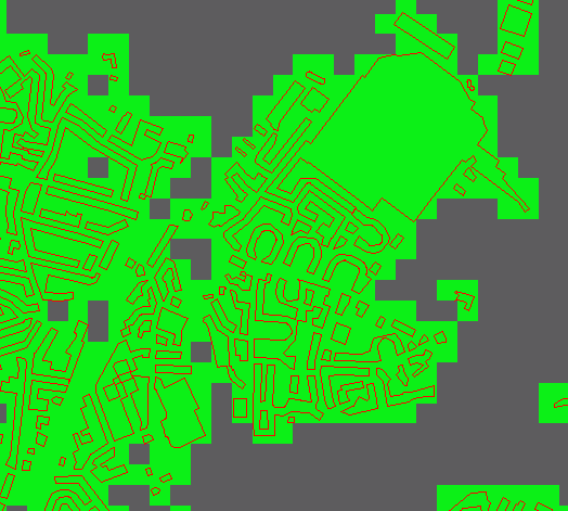
My colleague converted a polygon dataset (buildings) into a raster dataset where every 50m pixel that is "touched" by a polygon is given a 1 (green) and un-touching is a 0(gray); see the figure below.
[ATTACH=CONFIG]28754[/ATTACH]
This was achieved using GDAL and the ALL_TOUCHED parameter turned on.
How can this be achieved in ArcMap? If I use Polygon to Raster tool and regardless of the cell Assignment parameter I cannot achieve this affect. I tried converting my polygons to polylines and then using the polyline to raster tool but large polygons greater than 50m end up creating "donuts" as shown below:
[ATTACH=CONFIG]28755[/ATTACH]
Is ArcMap capable of creating a raster where every cell is assigned a value when it intersects or touched by a polygon?
Duncan
0 Replies