- Home
- :
- All Communities
- :
- Products
- :
- Data Management
- :
- Data Management Questions
- :
- Re: Grayed-out Set Data Source Button
- Subscribe to RSS Feed
- Mark Topic as New
- Mark Topic as Read
- Float this Topic for Current User
- Bookmark
- Subscribe
- Mute
- Printer Friendly Page
- Mark as New
- Bookmark
- Subscribe
- Mute
- Subscribe to RSS Feed
- Permalink
Using these instructions, I have added a Set Data Source button to my main tool bar for ArcMap. The button, however, is grayed-out and I can't seem to find what would cause this so I can fix it. Advice would be gratefully received. I am running 10.3.1. Thanks much.
Solved! Go to Solution.
Accepted Solutions
- Mark as New
- Bookmark
- Subscribe
- Mute
- Subscribe to RSS Feed
- Permalink
Based on the help page and process you included in you post, it looks like that tool requires the Defense Mapping Extension. Do yo have that extension?
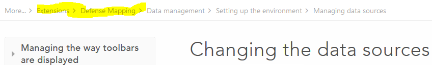
If not, there are other ways to update data sources...
- if there are red ! next to a feature class in an ArcMap app, this means these is a broken link (which it doesn't appear that these are). If you know the correct path, you can right-click on the ! and update the path....all others in the relative path will be corrected.
- If you want to change/fix the data source for one of the layers in an ArcMap doc, you can right-click the item, select Properties and update it there
- [I think this option would be closest to the tool you were trying to use] in ArcCatalog, you can right-click on the ArcMap mxd and use Setting data sources—Help | ArcGIS for Desktop The interface isn't as robust as the version with the extension, but it will allow for point to different data sources, either one layer (in the ArcMap doc) at a time, or selecting all.
- Use arcpy mapping to update data sources Updating and fixing data sources with arcpy.mapping—Help | ArcGIS for Desktop
- and I'll include my addin, which is aimed more at fixing broken links in multiple documents, but if you are familiar with python you can see how I did it and modify it. But for one doc, I would say it isn't worth it. Python addin for data inventory and “broken-link” repair.
IF by chance you DO have the Defense Mapping extension, it may just be you have not installed or activated it. I do not have the extension, so not sure the way to do that (and didn't have luck finding a simple help page for it), but it may be a matter of selecting it under Customize->Extensions.
- Mark as New
- Bookmark
- Subscribe
- Mute
- Subscribe to RSS Feed
- Permalink
William...This is the place for help about GeoNet GeoNet Community Structure
I have moved this to Managing Data to attract a wider audience
As a check, do you have a layer selected when you active this option? or the dataframe's name/
- Mark as New
- Bookmark
- Subscribe
- Mute
- Subscribe to RSS Feed
- Permalink
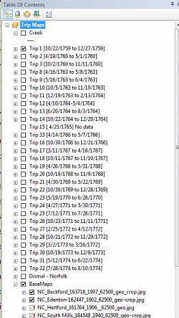
I do have layers selected as shown in the screen grab below. Thank you very much for putting my question in the right slot. I'm still not entirely sure how to work GeoNet and it shows.
- Mark as New
- Bookmark
- Subscribe
- Mute
- Subscribe to RSS Feed
- Permalink
Ok... you have the title of the table of contents selected... not one of the layers underneath
- Mark as New
- Bookmark
- Subscribe
- Mute
- Subscribe to RSS Feed
- Permalink
If the layer is a part of a basemap layer, you won't get the option of setting the data source. Copy the layer outside the basemap layer, change the data source of the independent layer, and replace it back to the basemap layer.
Think Location
- Mark as New
- Bookmark
- Subscribe
- Mute
- Subscribe to RSS Feed
- Permalink
Hi,
This happens because ArcMap is not able to find the data source i.e it is the case of broken data link.
See this;
- Mark as New
- Bookmark
- Subscribe
- Mute
- Subscribe to RSS Feed
- Permalink
Based on the help page and process you included in you post, it looks like that tool requires the Defense Mapping Extension. Do yo have that extension?
If not, there are other ways to update data sources...
- if there are red ! next to a feature class in an ArcMap app, this means these is a broken link (which it doesn't appear that these are). If you know the correct path, you can right-click on the ! and update the path....all others in the relative path will be corrected.
- If you want to change/fix the data source for one of the layers in an ArcMap doc, you can right-click the item, select Properties and update it there
- [I think this option would be closest to the tool you were trying to use] in ArcCatalog, you can right-click on the ArcMap mxd and use Setting data sources—Help | ArcGIS for Desktop The interface isn't as robust as the version with the extension, but it will allow for point to different data sources, either one layer (in the ArcMap doc) at a time, or selecting all.
- Use arcpy mapping to update data sources Updating and fixing data sources with arcpy.mapping—Help | ArcGIS for Desktop
- and I'll include my addin, which is aimed more at fixing broken links in multiple documents, but if you are familiar with python you can see how I did it and modify it. But for one doc, I would say it isn't worth it. Python addin for data inventory and “broken-link” repair.
IF by chance you DO have the Defense Mapping extension, it may just be you have not installed or activated it. I do not have the extension, so not sure the way to do that (and didn't have luck finding a simple help page for it), but it may be a matter of selecting it under Customize->Extensions.
- Mark as New
- Bookmark
- Subscribe
- Mute
- Subscribe to RSS Feed
- Permalink
Rebecca, thanks very much for the information. There are so many ways to do the same thing in ArcGIS, that for those of us who don't do this full-time, confusion sometimes sets in. I have managed to get my overarching problem solved and now have some time to refine an approach and learn a bit more about how to do things more elegantly and with less effort. It was kind of you to spend time preparing an answer.
- Mark as New
- Bookmark
- Subscribe
- Mute
- Subscribe to RSS Feed
- Permalink
Glad to help. You are correct, always more than one way to do things, and I probably missed one too. But glad you were able to resolve your immediate issue.
Don't forget to mark this thread as answered.