- Home
- :
- All Communities
- :
- Products
- :
- Data Management
- :
- Data Management Questions
- :
- GIS Anno Layer to CAD with Data Interoperability?
- Subscribe to RSS Feed
- Mark Topic as New
- Mark Topic as Read
- Float this Topic for Current User
- Bookmark
- Subscribe
- Mute
- Printer Friendly Page
GIS Anno Layer to CAD with Data Interoperability?
- Mark as New
- Bookmark
- Subscribe
- Mute
- Subscribe to RSS Feed
- Permalink
I've been experimenting with Data Interoperability the past couple of days trying to do a simple GIS to CAD tool. I created a file geodatabase that contains our street centerlines and the street centerlines annotation layers. I want to export these features to an AutoCAD .dwg, but can't seem to get the annotation layer to cooperate. I've followed the steps outlined here: Reading Basic Geodatabase Annotation - GDB to DWG - FME Knowledge Center. However, I still do not get annotation output to the .dwg file, only the lines.
In the Translation Log, I see the following message that stands out:
Reading table/feature class 'RoadCenterlinesAnno'
Geometry type esriGeometryBag is invalid for an annotation. If reading multi-part annotations, please set SPLIT_MULTI_PART_ANNOS to 'yes', or switch to classic geometry mode in order to read each part as a separate feature
... Last line repeated 114 times ...
Reading source feature # 7500
Geometry type esriGeometryBag is invalid for an annotation. If reading multi-part annotations, please set SPLIT_MULTI_PART_ANNOS to 'yes', or switch to classic geometry mode in order to read each part as a separate feature
... Last line repeated 791 times ...
An annotation feature, for the table 'RoadCenterlinesAnno', was found that is incomplete (or is not actually an annotation). The feature will still be translated, but will not contain any geometry or any annotation specific attributes. Its geodb_type will be set to 'geodb_undefined'
... Last line repeated 2 times ...
Geometry type esriGeometryBag is invalid for an annotation. If reading multi-part annotations, please set SPLIT_MULTI_PART_ANNOS to 'yes', or switch to classic geometry mode in order to read each part as a separate feature
... Last line repeated 72 times ...
Closing the Geodatabase reader
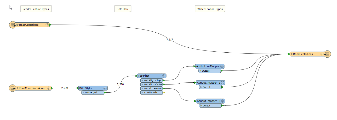
Being new to Data Interoperability, I can't seem to find where to set the 'SPLIT_MULTI_PART_ANNOS' or switch to classic geometry mode. I've also attached an image of my workflow for reference.
Does anyone have any tips on getting an annotation layer to convert into a .dwg file or know where I went wrong above? Thanks for the help!