- Home
- :
- All Communities
- :
- Products
- :
- Data Management
- :
- Data Management Questions
- :
- Re: georeference sid
- Subscribe to RSS Feed
- Mark Topic as New
- Mark Topic as Read
- Float this Topic for Current User
- Bookmark
- Subscribe
- Mute
- Printer Friendly Page
georeference sid
- Mark as New
- Bookmark
- Subscribe
- Mute
- Subscribe to RSS Feed
- Permalink
Hi, I am fairly new to ArcGIS Desktop and GIS, so forgive me if my explanation is not too clear.
I have received a few sid files that span several years, all at the same location. I would like to georeference those files so I can add my vector information. These files are at different scales and I imported each one by going add-data->Data
What would be the process or can someone point me in the direction to georeference these files. I have been looking at the documentation, but no luck so far
Thanks
- Mark as New
- Bookmark
- Subscribe
- Mute
- Subscribe to RSS Feed
- Permalink
You would be advised to convert the sid files to a different format which isn't proprietary
Supported raster dataset file formats—Help | ArcGIS for Desktop
FME can do the translation LizardTech MrSID Data | FME | Safe Software
and I suspect if you can view them you can export them as well using one of the conventional formats
Raster To Other Format—Help | ArcGIS for Desktop
everyone has their favorites and I don't want to start a flame war, but I prefer lossless smaller file size versions like *.png although the many prefer the larger potentially lossy different versions of *.tif (tiff)
- Mark as New
- Bookmark
- Subscribe
- Mute
- Subscribe to RSS Feed
- Permalink
OK I will convert to png and give that a shot. Thanks as always
- Mark as New
- Bookmark
- Subscribe
- Mute
- Subscribe to RSS Feed
- Permalink
Normally your files have a spatial reference already defined within the metadata. When you open the SID properties in Catalog (right click > Properties), is there a Spatial Reference? If the file already has a spatial reference, then it will not show in the Georeferencing Toolbar even if you convert it to another format such as TIFF. You would have to use the Project Raster tool to assign an undefined spatial reference to the raster.
Do you have any other reference data to see where the SID is displaying when you add it to ArcMap?
- Mark as New
- Bookmark
- Subscribe
- Mute
- Subscribe to RSS Feed
- Permalink
Hi Timothy, thanks for the reply. There is no Spatial Reference for the sid files. Here is a screenshot of the metadata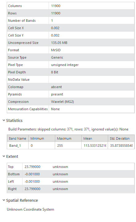
- Mark as New
- Bookmark
- Subscribe
- Mute
- Subscribe to RSS Feed
- Permalink
Ok, then you will need to convert it to another format as Dan mentioned. Keep in mind that SID files are highly compressed, and the storage for the new file will be significantly greater. In the example above it's only 135mb uncompressed so that's not bad, but keep an eye on this for other rasters.