Turn on suggestions
Auto-suggest helps you quickly narrow down your search results by suggesting possible matches as you type.
Cancel
- Home
- :
- All Communities
- :
- Products
- :
- Data Management
- :
- Data Management Questions
- :
- Geocoding to intersection by subdivision name
Options
- Subscribe to RSS Feed
- Mark Topic as New
- Mark Topic as Read
- Float this Topic for Current User
- Bookmark
- Subscribe
- Mute
- Printer Friendly Page
Geocoding to intersection by subdivision name
Subscribe
1663
0
12-18-2012 10:49 AM
12-18-2012
10:49 AM
- Mark as New
- Bookmark
- Subscribe
- Mute
- Subscribe to RSS Feed
- Permalink
I'm hoping for a little help brainstorming here with address locator creation.
We're a Spillman 911 client, but unfortunately their support doesn't handle the logistics of setting up geocoding.
Here's our problem:
As with most public safety agencies, our folks in the field will often give a location as Road X at Subdivision Z. An example might be a wreck at Highway 85 and Kingswood Estates. In these instances, it is much more likely that the call will come in this way, and not with the name of that street that intersects Highway 85.
So, I'm trying to formulate a process for creating, but also maintaining these intersections.
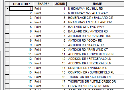
Spillman's own tools are capable of creating intersection points that contain a field with the name of the intersection (e.g. "Highway 85 / Albion Dr"), and that same tool will also create an alias table linked by a unique ID. The alias field in that table contains all possible parsings of the intersection name from the points' table.
The points are created from a street centerline file (attached screenshot gives an idea of how it works).
So...
This process of updating Intersection points and their alias table is repeated periodically, but it includes only street names. What I need to do is find a way to incorporate subdivision names into either the points or the alias table. I will also need this to be something that can be automated, so that each time I run the tool to recreate the points, I can then also update the subdivision aliases.
Our Subdivisions are stored in a polygon feature class.
Worst case, I could also just create a totally separate Intersection point file containing the subdivision names instead of cross-street names.
Thanks for any advice.
[ATTACH=CONFIG]20048[/ATTACH]
[ATTACH=CONFIG]20046[/ATTACH][ATTACH=CONFIG]20045[/ATTACH]
We're a Spillman 911 client, but unfortunately their support doesn't handle the logistics of setting up geocoding.
Here's our problem:
As with most public safety agencies, our folks in the field will often give a location as Road X at Subdivision Z. An example might be a wreck at Highway 85 and Kingswood Estates. In these instances, it is much more likely that the call will come in this way, and not with the name of that street that intersects Highway 85.
So, I'm trying to formulate a process for creating, but also maintaining these intersections.
Spillman's own tools are capable of creating intersection points that contain a field with the name of the intersection (e.g. "Highway 85 / Albion Dr"), and that same tool will also create an alias table linked by a unique ID. The alias field in that table contains all possible parsings of the intersection name from the points' table.
The points are created from a street centerline file (attached screenshot gives an idea of how it works).
So...
This process of updating Intersection points and their alias table is repeated periodically, but it includes only street names. What I need to do is find a way to incorporate subdivision names into either the points or the alias table. I will also need this to be something that can be automated, so that each time I run the tool to recreate the points, I can then also update the subdivision aliases.
Our Subdivisions are stored in a polygon feature class.
Worst case, I could also just create a totally separate Intersection point file containing the subdivision names instead of cross-street names.
Thanks for any advice.
[ATTACH=CONFIG]20048[/ATTACH]
[ATTACH=CONFIG]20046[/ATTACH][ATTACH=CONFIG]20045[/ATTACH]
0 Replies