Turn on suggestions
Auto-suggest helps you quickly narrow down your search results by suggesting possible matches as you type.
Cancel
- Home
- :
- All Communities
- :
- Products
- :
- Data Management
- :
- Data Management Questions
- :
- Geocoding Project
Options
- Subscribe to RSS Feed
- Mark Topic as New
- Mark Topic as Read
- Float this Topic for Current User
- Bookmark
- Subscribe
- Mute
- Printer Friendly Page
06-24-2013
09:31 AM
- Mark as New
- Bookmark
- Subscribe
- Mute
- Subscribe to RSS Feed
- Permalink
I am in charge of a GIS project for an internship I am doing this summer. I have taken a few GIS classes but by no means am I an expert, and no one in the office knows much about GIS. I have to map the locations of their projects, most of which have been in Colorado. I have the specific addresses and zip codes for most of the projects as well as the counties. What would be the best way to go about this? I have added the Colorado state boundary and county boundaries (I also have access to the zip code boundaries for Colorado). I know I have to geocode the addresses to a layer of street data for Colorado (which I have never done before), but have been unable to find any layers that are suitable for this. Any tips on where to locate a layer such as this or on geocoding would be much appreciated.
Thanks!
Thanks!
Solved! Go to Solution.
1 Solution
Accepted Solutions
07-03-2013
03:14 AM
- Mark as New
- Bookmark
- Subscribe
- Mute
- Subscribe to RSS Feed
- Permalink
Hello again!
I am having trouble creating the address locator from the street data I have and my data table. I obtained the street data from a US Major Roads layer found on ArcGIS online, and selected and exported only the roads in Colorado. I have read many tutorials and
watched some videos online about creating an address locator and I am afraid the street layer does not have all of the necessary
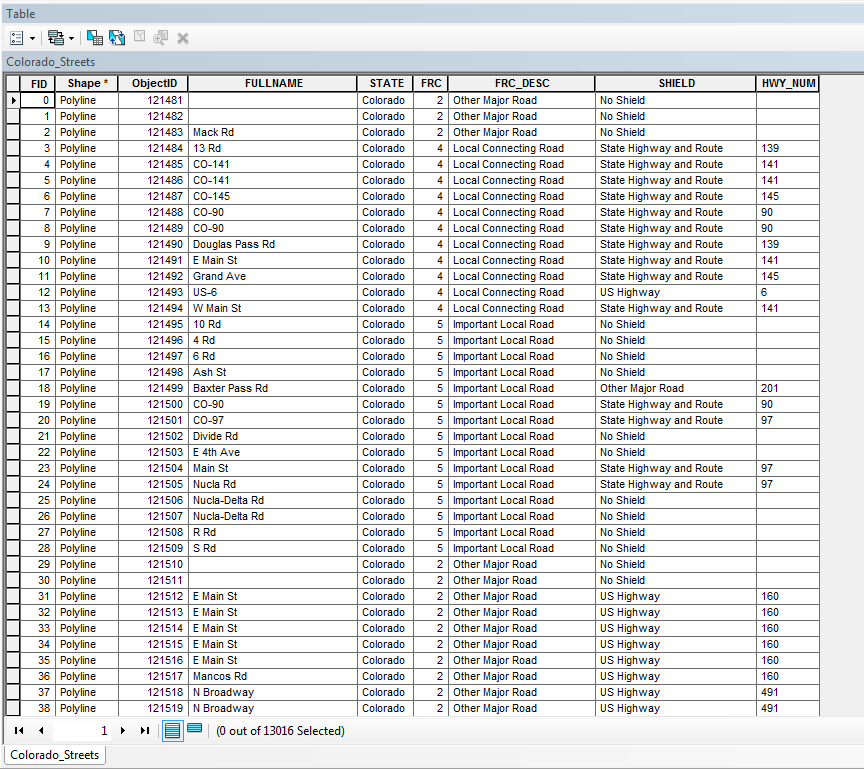
data. I have attached a copy of the project data I am using as well as a snapshot of the street attribute table (which consists of 13015 attributes). Does the street layer need more information such as distance from/to the right/left/etc? I appreciate all the help!
Cameron- let's get some nomenclature taken care of first: the street data you show has 13015 RECORDS but only a handful of attributes: records are rows, attributes are columns. This particular street data does not have the proper attributes to support geocoding.
I've been surfing around looking for a good source of street centerline data for Colorado this morning. So far the best information is the tiger-line data from the US Census; check out this pdf that has download instructions and use instructions. Once the sun comes up, I'll make a call or two to some of my Colorado contacts and see what they can suggest as well.
Your address data looks good, but needs a few minor tweaks: get rid of any special characters, suite numbers and then standardize your street types. For example:
603 Main STREET, Suite 2 should be cleaned up to
603 MAIN ST
Some of your address have STREET others have ST. Some have AVENUE others have AVE. No sense reinventing the wheel here; the USPS has a list of standards you can follow.Click on the abbreviations tab. (I use these in two major 9-1-1 call centers in Utah and geocode/dispatch hundreds of thousands of calls per year: when seconds count, help is only minutes away...)
This should keep you busy; I'm grabbing another cup of coffee and watch the sunrise. (BTW, don't be shy about following the instructions given in my signature block below.)
That should just about do it....
7 Replies
06-24-2013
09:43 AM
- Mark as New
- Bookmark
- Subscribe
- Mute
- Subscribe to RSS Feed
- Permalink
This is like deja vu all over again; I swear I replied to this same post last week or so and I remember someone from ESRI responding as well.
My response was to get some local street data from Colorado or the Counties; the other response was to use the packaged data that comes with ArcGIS.
Either way, take a look at the online help on how to create a locator, and you'll be good to go.
My response was to get some local street data from Colorado or the Counties; the other response was to use the packaged data that comes with ArcGIS.
Either way, take a look at the online help on how to create a locator, and you'll be good to go.
That should just about do it....
06-24-2013
01:11 PM
- Mark as New
- Bookmark
- Subscribe
- Mute
- Subscribe to RSS Feed
- Permalink
Thanks for the response, and, yes, I did post something similarly last week. I was just having difficulty finding a layer with sufficient street data. However, I've resorted to doing it by county, but I am having difficulty joining the table to the layer of Colorado counties. I need to create a many-to-one relationship between the table and counties layer because some counties have more than one project that was completed in that county. When I join them, it takes the first project from each county and that's it, so out of the 63 projects I want to map, only 24 show up. Is there a better way to do this? I appreciate all the help (this week and last).
06-25-2013
03:33 AM
- Mark as New
- Bookmark
- Subscribe
- Mute
- Subscribe to RSS Feed
- Permalink
Thanks for the response, and, yes, I did post something similarly last week. I was just having difficulty finding a layer with sufficient street data. However, I've resorted to doing it by county, but I am having difficulty joining the table to the layer of Colorado counties. I need to create a many-to-one relationship between the table and counties layer because some counties have more than one project that was completed in that county. When I join them, it takes the first project from each county and that's it, so out of the 63 projects I want to map, only 24 show up. Is there a better way to do this? I appreciate all the help (this week and last).
You can create a locator based on the county name: look here to learn about a general, sing field type of locator. I believe that this method will 'stack' your project points in a pile at the centroid of the county polygon centroid. Take a look at using the dot density method to represent them on a map.
That should just about do it....
07-02-2013
10:15 AM
- Mark as New
- Bookmark
- Subscribe
- Mute
- Subscribe to RSS Feed
- Permalink
Hello again!
I am having trouble creating the address locator from the street data I have and my data table. I obtained the street data from a US Major Roads layer found on ArcGIS online, and selected and exported only the roads in Colorado. I have read many tutorials and
watched some videos online about creating an address locator and I am afraid the street layer does not have all of the necessary
data. I have attached a copy of the project data I am using as well as a snapshot of the street attribute table (which consists of 13015 attributes). Does the street layer need more information such as distance from/to the right/left/etc? I appreciate all the help!
07-03-2013
03:14 AM
- Mark as New
- Bookmark
- Subscribe
- Mute
- Subscribe to RSS Feed
- Permalink
Hello again!
I am having trouble creating the address locator from the street data I have and my data table. I obtained the street data from a US Major Roads layer found on ArcGIS online, and selected and exported only the roads in Colorado. I have read many tutorials and
watched some videos online about creating an address locator and I am afraid the street layer does not have all of the necessary
data. I have attached a copy of the project data I am using as well as a snapshot of the street attribute table (which consists of 13015 attributes). Does the street layer need more information such as distance from/to the right/left/etc? I appreciate all the help!
Cameron- let's get some nomenclature taken care of first: the street data you show has 13015 RECORDS but only a handful of attributes: records are rows, attributes are columns. This particular street data does not have the proper attributes to support geocoding.
I've been surfing around looking for a good source of street centerline data for Colorado this morning. So far the best information is the tiger-line data from the US Census; check out this pdf that has download instructions and use instructions. Once the sun comes up, I'll make a call or two to some of my Colorado contacts and see what they can suggest as well.
Your address data looks good, but needs a few minor tweaks: get rid of any special characters, suite numbers and then standardize your street types. For example:
603 Main STREET, Suite 2 should be cleaned up to
603 MAIN ST
Some of your address have STREET others have ST. Some have AVENUE others have AVE. No sense reinventing the wheel here; the USPS has a list of standards you can follow.Click on the abbreviations tab. (I use these in two major 9-1-1 call centers in Utah and geocode/dispatch hundreds of thousands of calls per year: when seconds count, help is only minutes away...)
This should keep you busy; I'm grabbing another cup of coffee and watch the sunrise. (BTW, don't be shy about following the instructions given in my signature block below.)
That should just about do it....
07-03-2013
10:56 AM
- Mark as New
- Bookmark
- Subscribe
- Mute
- Subscribe to RSS Feed
- Permalink
I appreciate all of the help, Joe. I have fixed my excel sheet so it is compatible. I am still working on finding a street layer via the
Tiger shapefiles you suggested. Hopefully i come across something that works. Again, thanks for the help.
Tiger shapefiles you suggested. Hopefully i come across something that works. Again, thanks for the help.
07-03-2013
10:58 AM
- Mark as New
- Bookmark
- Subscribe
- Mute
- Subscribe to RSS Feed
- Permalink
Just hit the mother lode for Denver. I couldn't get to this site earlier today, but it's got just what I had hoped to find and then some:
http://data.denvergov.org/dataset/city-and-county-of-denver-street-centerline
And this place has many other Colorado jurisdictions:
http://data.opencolorado.org/
http://data.denvergov.org/dataset/city-and-county-of-denver-street-centerline
And this place has many other Colorado jurisdictions:
http://data.opencolorado.org/
That should just about do it....