Turn on suggestions
Auto-suggest helps you quickly narrow down your search results by suggesting possible matches as you type.
Cancel
- Home
- :
- All Communities
- :
- Products
- :
- Data Management
- :
- Data Management Questions
- :
- DigitalGlobe images
Options
- Subscribe to RSS Feed
- Mark Topic as New
- Mark Topic as Read
- Float this Topic for Current User
- Bookmark
- Subscribe
- Mute
- Printer Friendly Page
DigitalGlobe images
Subscribe
5991
5
11-25-2013 03:16 PM
11-25-2013
03:16 PM
- Mark as New
- Bookmark
- Subscribe
- Mute
- Subscribe to RSS Feed
- Permalink
I just got some digitalglobe data that I would like to orthorectify. The instructions on the desktop help assume that the RPC files are in the format .rpg (http://help.arcgis.com/en/arcgisdesktop/10.0/help/index.html#//009t000000ms000000), however, the data I received is in DIMAP format so the RPC files are in xml.
Not sure what to do with this, when I open the image in Arc, it doesn't recognize that there are ortho files. Thanks for your help!
Not sure what to do with this, when I open the image in Arc, it doesn't recognize that there are ortho files. Thanks for your help!
5 Replies
11-25-2013
08:31 PM
- Mark as New
- Bookmark
- Subscribe
- Mute
- Subscribe to RSS Feed
- Permalink
I just got some digitalglobe data that I would like to orthorectify. ... however, the data I received is in DIMAP format so the RPC files are in xml.
...
Pls attach the metadata/RPC files (.xml or .txt), and the snapshot of the data folder structure as well.
It looks me that your data are SPOT 5 (DIMAP), which should come from �??Astrium�??. For more on DIMAP, link to http://www2.astrium-geo.com/files/pmedia/public/r455_9_formatdimap_eng_sept2010.pdf .
With DigitalGlobe, data should be referred to QuickBird/ WorldView (RPB) or GeoEye/ IKONOS (RPC) , which was merged into the DigitalGlobe on January 2013.
++++
For ortho rectification on SPOT 5 DIMAP, advisable to try ArcGIS 10.2 and see if it meets your needs. Personally, it is still challenging to 'properly' handle SPOT 5 DIMAP images within ArcGIS 10.x, including 10.2.
11-26-2013
05:38 AM
- Mark as New
- Bookmark
- Subscribe
- Mute
- Subscribe to RSS Feed
- Permalink
Pls attach the metadata/RPC files (.xml or .txt), and the snapshot of the data folder structure as well.
It looks me that your data are SPOT 5 (DIMAP), which should come from �??Astrium�??. For more on DIMAP, link to http://www2.astrium-geo.com/files/pmedia/public/r455_9_formatdimap_eng_sept2010.pdf .
With DigitalGlobe, data should be referred to QuickBird/ WorldView (RPB) or GeoEye/ IKONOS (RPC) , which was merged into the DigitalGlobe on January 2013.
++++
For ortho rectification on SPOT 5 DIMAP, advisable to try ArcGIS 10.2 and see if it meets your needs. Personally, it is still challenging to 'properly' handle SPOT 5 DIMAP images within ArcGIS 10.x, including 10.2.
Yes, so it seems that although I ordered the data from Digital Globe, it was passed off to a third party for fulfillment. The consequence of this is that they gave me Pleiades data which is in another format. I had originally requested WorldView2 data so I am not sure why they sent me Pleiades data without telling me they were changing the platform. I'm a little frustrated to say the least. So now I need to figure out how to orthorectify the Pleiades data. I can't seem to find any information out there so help would be much appreciated.
11-26-2013
01:54 PM
- Mark as New
- Bookmark
- Subscribe
- Mute
- Subscribe to RSS Feed
- Permalink
.... Pleiades data ...
With Pleiades in DIMAP V2 (an improved version of SPOT�??s DIMAP V1 format), only ArcGIS 10.2 supports it.
For handling Pleiades, advisable to try MD (mosaic dataset). And then share your experience, if possible.
For more details, pls check relevant helps in Documentation 10.2...
11-28-2013
08:50 AM
- Mark as New
- Bookmark
- Subscribe
- Mute
- Subscribe to RSS Feed
- Permalink
I can open the Pleiades raster in XML format in Arc, but it only partially draws the layer. So Arc, sort of recognizes it. I can also open it easily in ENVI, but in none of the formats I save it in does Arc recognize the geospatial data.
It seems sort of ridiculous to have to go through the process of defining the spatial reference information when it is in the ancillary XML file (and ENVI recognizes it).
Trying to figure out the mosaic dataset now.
will let you know how that goes
It seems sort of ridiculous to have to go through the process of defining the spatial reference information when it is in the ancillary XML file (and ENVI recognizes it).
Trying to figure out the mosaic dataset now.
will let you know how that goes
12-02-2013
08:46 PM
- Mark as New
- Bookmark
- Subscribe
- Mute
- Subscribe to RSS Feed
- Permalink
I can open the Pleiades raster in XML format in Arc, but it only partially draws the layer. So Arc, sort of recognizes it. I can also open it easily in ENVI, but in none of the formats I save it in does Arc recognize the geospatial data.
It seems sort of ridiculous to have to go through the process of defining the spatial reference information when it is in the ancillary XML file (and ENVI recognizes it).
...
If ENVI is available to you, it is good idea to directly use it for orthorectificaon. Just make sure that GCP (ground control points) should be collected and combined into the workflow in ENVI 5.0 SP3. (In fact, it should be optional, i.e., with/without GCP).
++++++++
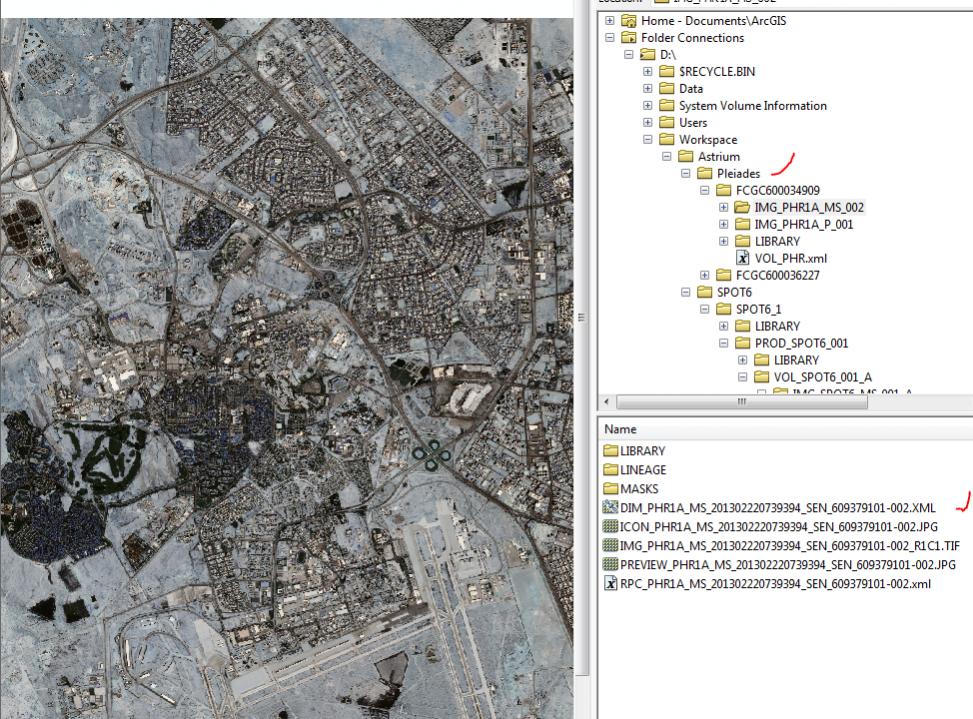
With 10.2, we can drag-drop DIM images into ArcMap without problem (see the attachment).
However, ArcGIS 10.2 might have bugs to smoothly load/orthorectify Pleiades DIMAP images into MD (SPOT6 DIMAP/ SPOT 5 DIMAP neither), at least, in most scenarios. I believe, it is challenging to deal with DIMAP images from Astrium in ArcGIS 10.x�?�