- Home
- :
- All Communities
- :
- Products
- :
- Data Management
- :
- Data Management Questions
- :
- Create Mosaic Dataset
- Subscribe to RSS Feed
- Mark Topic as New
- Mark Topic as Read
- Float this Topic for Current User
- Bookmark
- Subscribe
- Mute
- Printer Friendly Page
Create Mosaic Dataset
- Mark as New
- Bookmark
- Subscribe
- Mute
- Subscribe to RSS Feed
- Permalink
Hello I wonder which settings / coordinate system I should use when import photos from UAV DJI Phantom 4 in a Mosaic Dataset(Create Mosaic dataset)? I have test WGS 84 but error...
- Mark as New
- Bookmark
- Subscribe
- Mute
- Subscribe to RSS Feed
- Permalink
What format are the source rasters in? tif?
What coordinate system are the source rasters it?
What system you select for the mosaic depends in part on what you want to do with it. If it is a small area and just want to look at it in Arc and you are in the US I would go for the state plane system of the image area...
What is the error message?
- Mark as New
- Bookmark
- Subscribe
- Mute
- Subscribe to RSS Feed
- Permalink
Raster in JPEG format
DJI Phantom standard output coordinate system (part of my question).
Ok state plane system.. so in Sweden it´s WGS_1984_UTM_zone_33?
- Mark as New
- Bookmark
- Subscribe
- Mute
- Subscribe to RSS Feed
- Permalink
http://tech2mine.maps.arcgis.com/apps/Solutions/s2.html?appid=ef12074d67f648a7825cc7ed160d68fa
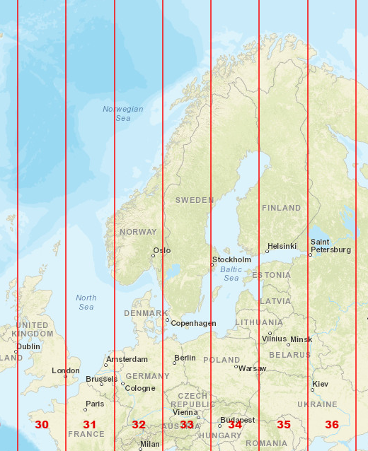
Yes. Looks like Sweden falls within a few UTM zones. With most of it zone 33.
Unfortunately, I don't know anything about the drone you are using. You will definitely need to know the system of the source rasters from the drone. I would think that the output system would be in the documentation some place. What happens if you just display one of the images in arc? Is that working ok?