- Home
- :
- All Communities
- :
- Products
- :
- Data Management
- :
- Data Management Questions
- :
- Create Fishnet
- Subscribe to RSS Feed
- Mark Topic as New
- Mark Topic as Read
- Float this Topic for Current User
- Bookmark
- Subscribe
- Mute
- Printer Friendly Page
- Mark as New
- Bookmark
- Subscribe
- Mute
- Subscribe to RSS Feed
- Permalink
Dear all!
I have to create a fishnet (raster) with a certain extend. I have a .shp file which has the needed extend which i should use. But my collegue tells me that a cell size should be 2/3 degree (latitude) x 1/2 degree (longtitude). He gives me the example from:
But for me that makes not really sense, because i have the extend from my .shp?
Does someone know what my mistake it? I started now within ArcMap to create a fishnet for the .shp with the data:
Data Type: Shapefile Feature Class
Shapefile: C:\DATEN_FINAL\xxx.shp
Geometry Type: Polygon
Coordinates have Z values: No
Coordinates have measures: No
Projected Coordinate System: ETRS_1989_LAEA
Projection: Lambert_Azimuthal_Equal_Area
False_Easting: 4321000,00000000
False_Northing: 3210000,00000000
Central_Meridian: 10,00000000
Latitude_Of_Origin: 52,00000000
Linear Unit: Meter
Geographic Coordinate System: GCS_ETRS_1989
Datum: D_ETRS_1989
Prime Meridian: Greenwich
Angular Unit: Degree
Like a spatial resolution for (deg lat x deg lon) 1/2 x 2/3 is needed but how can i combine this with the extention of my .shp?
Thank you so much in advance for your help!
Best,
Sophi
Solved! Go to Solution.
Accepted Solutions
- Mark as New
- Bookmark
- Subscribe
- Mute
- Subscribe to RSS Feed
- Permalink
I hope your shapefile's extent is large enough for creating multiple grids in FishNet.
If you want to specify the width and height in Decimal Degrees, you need to reproject the shapefile to a Geographic Coordinate System (e.g. GCS_ETRS_1989 [WKID: 4258]) .

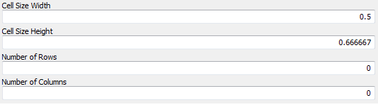
Then open a blank MXD > Add the new shapefile > Create Fishnet using the extent of the shapefile (Template Extent) with the desired cell_width (0.5) and cell_height (0.666667)
For number of rows and columns, keep it 0.
Geometry Type: Polygon
Think Location
- Mark as New
- Bookmark
- Subscribe
- Mute
- Subscribe to RSS Feed
- Permalink
Thank you!
Yes my .shp file is large enough. So than i use this .shp file with the new projection for the extent?
Or is the 2/3x1/2 the width and height?
- Mark as New
- Bookmark
- Subscribe
- Mute
- Subscribe to RSS Feed
- Permalink
First reproject to Geographic Coordinate System. This will ensure the map units are in Decimal Degrees.
Open a new map and add the reprojected shapefile.
Create FishNet with parameters cell_width : 0.5 and cell_height : 0.666667
Since the map units are in Decimal Degrees, the cell width and height will be 0.5° and 0.666667° respectively.
Think Location
- Mark as New
- Bookmark
- Subscribe
- Mute
- Subscribe to RSS Feed
- Permalink
A screenshot of Create Fishnet Tool
Think Location
- Mark as New
- Bookmark
- Subscribe
- Mute
- Subscribe to RSS Feed
- Permalink
Yes thank you! Exactly what i needed!
- Mark as New
- Bookmark
- Subscribe
- Mute
- Subscribe to RSS Feed
- Permalink
Glad it helped!!! 
Think Location
- Mark as New
- Bookmark
- Subscribe
- Mute
- Subscribe to RSS Feed
- Permalink
Just as an additional information:
I realized a little error here, the cell_width and cell_height has to be changed to cell_width (0.666667) and cell_height (0.5).
Because the longtitude is 2/3° and the latidude is 1/2°.
Best regards, S
- Mark as New
- Bookmark
- Subscribe
- Mute
- Subscribe to RSS Feed
- Permalink
Oh! The original question was the other way around.
But my collegue tells me that a cell size should be 2/3 degree (latitude) x 1/2 degree (longtitude).
The answer was based on that. Good to know that you realized the change in the values.
Think Location