- Home
- :
- All Communities
- :
- Products
- :
- Data Management
- :
- Data Management Questions
- :
- Counting points in buffers
- Subscribe to RSS Feed
- Mark Topic as New
- Mark Topic as Read
- Float this Topic for Current User
- Bookmark
- Subscribe
- Mute
- Printer Friendly Page
Counting points in buffers
- Mark as New
- Bookmark
- Subscribe
- Mute
- Subscribe to RSS Feed
- Permalink
Hi All,
Up until now, everyone on this forum has saved my bacon, so I thougt I would try my luck again! I am counting facilites (points) within buffers using spatial joing and sum, the problem, however, is this: when I do a 'blind eye' count, the count is 2, for example, in buffer A yet when I look at the spatial join count it shows as 10! Could someone suggest why this would occur? The points are listed as "multipoints" in the geography type, would this distort the count and if yes, how do I rectify this issue?
Thanking you in advance!
- Mark as New
- Bookmark
- Subscribe
- Mute
- Subscribe to RSS Feed
- Permalink
The multipoint geometry could be causing the issue. The geometry should be "point".
Use the following steps to convert the above data to point feature class.
1. Add two new fields in the attribute table, viz., "X" and "Y". Calculate the respective X and Y coordinates using CALCULATE GEOMETRY. Choose "Decimal Degrees" as units.
2. Using Table to Excel tool, convert the table to Excel.
3. Open the excel file in MS Excel. Delete the Geometry field.
4. In ArcMap, File > Add Data > Add XY data. Use appropriate spatial reference (e.g. GCS_WGS_1984 or any other appropriate GCS).
5. Export the Event layer to a Feature class/shapefile.
Then try the Spatial Join once again.
Think Location
- Mark as New
- Bookmark
- Subscribe
- Mute
- Subscribe to RSS Feed
- Permalink
blow the file apart using Multipart To Singlepart—Help | ArcGIS for Desktop
things are never as they appear, so don't rely on your eyes... always check the geometry
- Mark as New
- Bookmark
- Subscribe
- Mute
- Subscribe to RSS Feed
- Permalink
Thank you both, there goes a week of analysis, at least now I know what the issue was!
- Mark as New
- Bookmark
- Subscribe
- Mute
- Subscribe to RSS Feed
- Permalink
Also, would this method also work;
How To: Convert a multipoint feature class into a point feature class ?
- Mark as New
- Bookmark
- Subscribe
- Mute
- Subscribe to RSS Feed
- Permalink
why not use the builtin tool? are you using an old version of arcmap (ie 9.3 or less as per the link you sent)
- Mark as New
- Bookmark
- Subscribe
- Mute
- Subscribe to RSS Feed
- Permalink
Hi All,
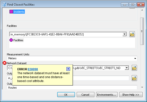
One last question: I am using Network Analyst to find the nearest distance to a park from a resident's location (i have converted the park polygons to line and then vertices). I keep getting this error? Could someone suggest an alternate?
- Mark as New
- Bookmark
- Subscribe
- Mute
- Subscribe to RSS Feed
- Permalink
it is referring to the road network not the facilities you should have had a shape field in the FC
- Mark as New
- Bookmark
- Subscribe
- Mute
- Subscribe to RSS Feed
- Permalink
Hi Dan,
Thanks for prompt response - I have setup a network dataset (shape file) that has streets and junctions, however, when I go into the properties toolbar to change the attributes of the network the only attribute listed is length, with no time component. Could you offer advice on how I might fix this? The XY are the resident locations, the greenspace file is the vertices of the green space, however, the network dataset is coming up as an error? The distance is the length, but why do I need to assign time to this?

- Mark as New
- Bookmark
- Subscribe
- Mute
- Subscribe to RSS Feed
- Permalink
the simplest way is to add a field and calculate time from an assumed speed of traversal.
Consider the simplest idea, that the speed 'limit' is 50 km/hour. You can calculate the time of traversal for a segment of a 'shape' from its length. So if you have a 1 km road, how long do you think it would take you in minutes or seconds to traverse that road segment? You can categorize your mode of transportation and/or road (read, network edges) according to a 'limit'. This obviously explains why the shortest path need not be the fastest since various routes to a destination from an origin can have different physical lengths and a 'temporal length'.
So you will have to add this constraint into your analysis, either keeping it simple, or categorizing your 'roads/edges/routes/paths' accordingly.