- Home
- :
- All Communities
- :
- Products
- :
- Data Management
- :
- Data Management Questions
- :
- Converted to Decimal Dgrees not mapping correctly?
- Subscribe to RSS Feed
- Mark Topic as New
- Mark Topic as Read
- Float this Topic for Current User
- Bookmark
- Subscribe
- Mute
- Printer Friendly Page
Converted to Decimal Dgrees not mapping correctly?
- Mark as New
- Bookmark
- Subscribe
- Mute
- Subscribe to RSS Feed
- Permalink
I converted data to decimal degrees. All my data in ArcMap is going through WGS 1984. However when it draws, my points they come out in a line far South of Texas. Any Ideas?
- Mark as New
- Bookmark
- Subscribe
- Mute
- Subscribe to RSS Feed
- Permalink
longitude is the X, latitude is the Y, what did you use to plot it? Also, a good idea to get rid of the blank rows before bringing it into ArcMap. Further details required as to your procedure otherwise any further answers would be guessing.
- Mark as New
- Bookmark
- Subscribe
- Mute
- Subscribe to RSS Feed
- Permalink
I have narrowed it down to being a space most likely in my latitude. (in excel) Once its in ArcMap I can see in attributes Latitude is null. I am brand new to GIS, but I believe I plotted it with WSG 1984. (That's what I set) I am importing from text file with wizard, its delineated with tabs, and I have set General/Text appropriately. Now I am just unsure how to locate the space and delete it. To convert I manually typed in formula and applied row by row.
- Mark as New
- Bookmark
- Subscribe
- Mute
- Subscribe to RSS Feed
- Permalink
Ok...
- the rows with blanks...get rid of them
- format every numeric column explicitly in Excel, hopefully any spuriuos data will appear.
- you can add Excel data to arcmap...but I will let others guide you on that since it causes no end of grief
- I would export the file to a *.csv file format
- use File|data|add XY data (or something like that) to add the csv file to arcmap
- specify Longitude as the X and latitude as the Y
if that doesn't work, then your numeric fields have 'crap' in them and will have to be processed out.
Good luck
- Mark as New
- Bookmark
- Subscribe
- Mute
- Subscribe to RSS Feed
- Permalink
Hi Ben,
Could you attach a snapshot of your excel sheet with the fieldnames and the sample Lon/Lat values?
Think Location
- Mark as New
- Bookmark
- Subscribe
- Mute
- Subscribe to RSS Feed
- Permalink
they are in an attachment to the original post, they do contain entries where coordinates are empty ie Alcino
- Mark as New
- Bookmark
- Subscribe
- Mute
- Subscribe to RSS Feed
- Permalink
Oops!!! Sorry. I checked it from my inbox, so missed the attachments.
Thanks Dan
Think Location
- Mark as New
- Bookmark
- Subscribe
- Mute
- Subscribe to RSS Feed
- Permalink
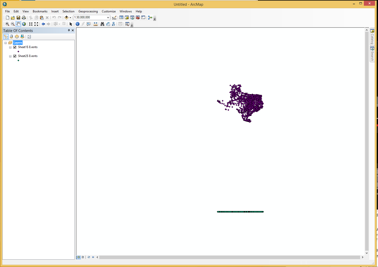
Hi Ben,
You could convert the Excel sheet to table. Then create XY data from table using GCS_WGS_1984 spatial reference. Export the event layer to shapefile.
Using select by attributes, select the records where latitude = 0.
Start Editing, and delete the selected records. Save and stop editing.
The resulting data looks like this, with 9272 records.

Thanks,
Jay
Think Location
- Mark as New
- Bookmark
- Subscribe
- Mute
- Subscribe to RSS Feed
- Permalink
Hi Ben,
I removed the trailing space from the "Latitude" field name and was able to display your points in ArcMap. Give that a shot.