- Home
- :
- All Communities
- :
- Products
- :
- Data Management
- :
- Data Management Questions
- :
- clip data management
- Subscribe to RSS Feed
- Mark Topic as New
- Mark Topic as Read
- Float this Topic for Current User
- Bookmark
- Subscribe
- Mute
- Printer Friendly Page
- Mark as New
- Bookmark
- Subscribe
- Mute
- Subscribe to RSS Feed
- Permalink
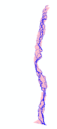
Hello people, I am trying to #clip raster by polygon to determine the area of the raster image within the shapefile area using ArcGIS 10.2.2. But the clipping is failing. I am using the Clip (Data Management) tool. Both the raster image and the shapefile polygon is in BTM (Bangladesh Transverse Mercator) projection system. I am keeping the "Use input features for clipping geometry" box checked and "Maintain clipping extent" box unchecked. I followed the same procedure for 15 other files which worked out fine. I am attaching the raster image and the shapefile hereby. I would be obliged if someone could help me over here. Thanks in advance.
Solved! Go to Solution.
Accepted Solutions
- Mark as New
- Bookmark
- Subscribe
- Mute
- Subscribe to RSS Feed
- Permalink
Close all ArcGIS Desktop applications. Open a new/blank ArcMap session.
Add the raster and polygon to the AcMap.
Run the tool (Also save the output Raster to a smaller pathname, not in the default.gdb; Also NO space and use underscore instead of any special character)
e.g. D:\Project\Data_2011.gdb\Jamuna_2011
Think Location
- Mark as New
- Bookmark
- Subscribe
- Mute
- Subscribe to RSS Feed
- Permalink
in 10.4 the extent is now expected to be rectangular Clip—Help | ArcGIS for Desktop
why not try the equivalent in Clip—Help | ArcGIS for Desktop
- Mark as New
- Bookmark
- Subscribe
- Mute
- Subscribe to RSS Feed
- Permalink
Right now 10.4 version is not available for me. Is there any other way to do it in version 10.2.2?
- Mark as New
- Bookmark
- Subscribe
- Mute
- Subscribe to RSS Feed
- Permalink
I am able to clip the Raster using Clip (Data Management). Turn off the Background processing (Geoprocessing > Geoprocessing Options) and try again.
Here is what I got
Think Location
- Mark as New
- Bookmark
- Subscribe
- Mute
- Subscribe to RSS Feed
- Permalink
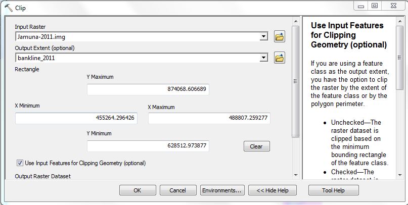
Thanks for you reply. Your output is exactly what I need, but it is failing even after turning off the background processing. The error message is like this-

- Mark as New
- Bookmark
- Subscribe
- Mute
- Subscribe to RSS Feed
- Permalink
Could you attach the screenshot of the tool with filled parameters (before running the tool)?
Think Location
- Mark as New
- Bookmark
- Subscribe
- Mute
- Subscribe to RSS Feed
- Permalink
Here they are.

- Mark as New
- Bookmark
- Subscribe
- Mute
- Subscribe to RSS Feed
- Permalink
Another tool would be Extract by Polygon—Help | ArcGIS for Desktop . Spatial Analyst extension required to run this tool.
Think Location
- Mark as New
- Bookmark
- Subscribe
- Mute
- Subscribe to RSS Feed
- Permalink
Close all ArcGIS Desktop applications. Open a new/blank ArcMap session.
Add the raster and polygon to the AcMap.
Run the tool (Also save the output Raster to a smaller pathname, not in the default.gdb; Also NO space and use underscore instead of any special character)
e.g. D:\Project\Data_2011.gdb\Jamuna_2011
Think Location
- Mark as New
- Bookmark
- Subscribe
- Mute
- Subscribe to RSS Feed
- Permalink
And finally this works! Changing the default output location! I can't stop laughing  Anyways, Dhonnobad (assuming from your name that you are a Bangali)!