- Home
- :
- All Communities
- :
- Products
- :
- Data Management
- :
- Data Management Questions
- :
- Calibrated route deviates from original line
- Subscribe to RSS Feed
- Mark Topic as New
- Mark Topic as Read
- Float this Topic for Current User
- Bookmark
- Subscribe
- Mute
- Printer Friendly Page
- Mark as New
- Bookmark
- Subscribe
- Mute
- Subscribe to RSS Feed
- Permalink
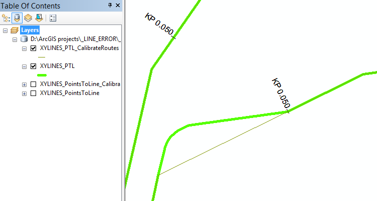
As shown in the picture below, my calibrated route deviates from the original route. It only happens in very few places, and I have no clue why this happens.
Anyone an idea?
GIS for Hydrographic Surveying
Solved! Go to Solution.
Accepted Solutions
- Mark as New
- Bookmark
- Subscribe
- Mute
- Subscribe to RSS Feed
- Permalink
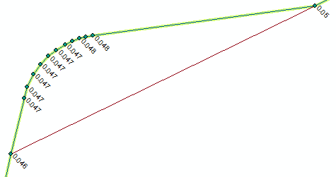
The problem is solved, there were some points along the route with the same M-Value. ArcGIS completely skips those points for calibration, and deviates from the original line.
The solution was to remove the point with identical M-values and recalibrate.
So it was a curve with real dense points and no Bezier curve.
- Mark as New
- Bookmark
- Subscribe
- Mute
- Subscribe to RSS Feed
- Permalink
Are you using calibration points, and if so, are there any points missing for the mis-shapen portion?
- Mark as New
- Bookmark
- Subscribe
- Mute
- Subscribe to RSS Feed
- Permalink
Is the curve in the original route densified points or a bezier curve? I would expect the bezier curve to cause issues and not be preserved by the route tools. I have similar problems with the Locate Features Along Routes tool when I try to overlay line features on to a route built from bezier curves originally.
- Mark as New
- Bookmark
- Subscribe
- Mute
- Subscribe to RSS Feed
- Permalink
The problem is solved, there were some points along the route with the same M-Value. ArcGIS completely skips those points for calibration, and deviates from the original line.
The solution was to remove the point with identical M-values and recalibrate.
So it was a curve with real dense points and no Bezier curve.