- Home
- :
- All Communities
- :
- Products
- :
- Data Management
- :
- Data Management Questions
- :
- BUFFER DIVISION
- Subscribe to RSS Feed
- Mark Topic as New
- Mark Topic as Read
- Float this Topic for Current User
- Bookmark
- Subscribe
- Mute
- Printer Friendly Page
BUFFER DIVISION
- Mark as New
- Bookmark
- Subscribe
- Mute
- Subscribe to RSS Feed
- Permalink
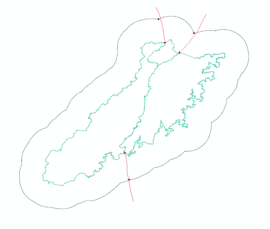
Hi, I am trying to derive reasonable statistics from a raster using buffers around protected areas. Some of them are contiguous so when I create the buffers there are multiple overlaps. I am trying to derive a division of the buffer so that every park has got just one reasonable (cut) buffer area. Any idea? cheers
- Mark as New
- Bookmark
- Subscribe
- Mute
- Subscribe to RSS Feed
- Permalink
did you try to union or intersect the overlapping buffers…?
The information that appears in the tables might be what you are looking for
- Mark as New
- Bookmark
- Subscribe
- Mute
- Subscribe to RSS Feed
- Permalink
The problem is dividing the overlapping portions of the buffers in a a reasonable way. It is a hard geometrical problem. One possible way is to connect intersecting buffer in the dissolved buffer perimeter and get the points (blue in the image), get the intesecting points in the periphery of the parks (red points) and connect a line (with I don't know which instruction) to find a way to cut the buffers (see red lines in the image). Thanks
- Mark as New
- Bookmark
- Subscribe
- Mute
- Subscribe to RSS Feed
- Permalink
any rule is acceptable as long as it is supported.
there is definitely no one approach and nothing automatic or tool-based
- Mark as New
- Bookmark
- Subscribe
- Mute
- Subscribe to RSS Feed
- Permalink
I'd be happy to know at leat one ![]()
- Mark as New
- Bookmark
- Subscribe
- Mute
- Subscribe to RSS Feed
- Permalink
well you have one.
Don't dissolve the buffers and assign those that clearly belong to one area to it...
what does that look like?
does that change the location of where you place your markers for division?
- Mark as New
- Bookmark
- Subscribe
- Mute
- Subscribe to RSS Feed
- Permalink
that would leave shared portions of buffer unassigned. Sometimes areas shared by a "triple overlap"
- Mark as New
- Bookmark
- Subscribe
- Mute
- Subscribe to RSS Feed
- Permalink
The rules get more complex making a simple solution almost impossible... I would just justify yours and use it... it will probably be as good if not better than anyone else's