Turn on suggestions
Auto-suggest helps you quickly narrow down your search results by suggesting possible matches as you type.
Cancel
- Home
- :
- All Communities
- :
- Products
- :
- Data Management
- :
- Data Management Questions
- :
- Re: ArcGIS10: Use xlsx file as Reference Data to c...
Options
- Subscribe to RSS Feed
- Mark Topic as New
- Mark Topic as Read
- Float this Topic for Current User
- Bookmark
- Subscribe
- Mute
- Printer Friendly Page
ArcGIS10: Use xlsx file as Reference Data to create Address Locator. Errors!!??
Subscribe
2259
3
04-18-2012 11:57 AM
by
Anonymous User
Not applicable
04-18-2012
11:57 AM
- Mark as New
- Bookmark
- Subscribe
- Mute
- Subscribe to RSS Feed
- Permalink
Original User: ScottChang25
Hi all,
I used an Excel 2007 worksheet to make an xlsx file:
OID Org_Name Address City State ZIP_Code
0 Kentucky Theatre 214 East Main Street Lexington KY 40507
1 Repulic Bank & Trust Company 2401 Harrodsburg Road Lexington KY 40504
2 Square D 1601 Mercer Road Lexington KY 40501
3 Community Trust Bank 901 Beaumont Centre Parkway Lexington KY 40513
4 Link-Belt Cranes 2651 Palumbo Drive Lexington KY 40909
5 Central Bank & Trust Company 3270 Tates Creek Road Lexington KY 40509
6 Glass America 3801 Nicholasville Centre Drive Lexington KY 40503
7 Odessa Roofing Inc & Repair 232 Gold Rush Road Lexington KY 40503
8 Blue Grass Plating Co. 451 North Estill Avenue Richmond KY 40475
9 Farmers Bank 213 East Main Street Wilmore KY 40390
10 Central Bank & Trust Co. 301 North Main Street Nicholasville KY 40356
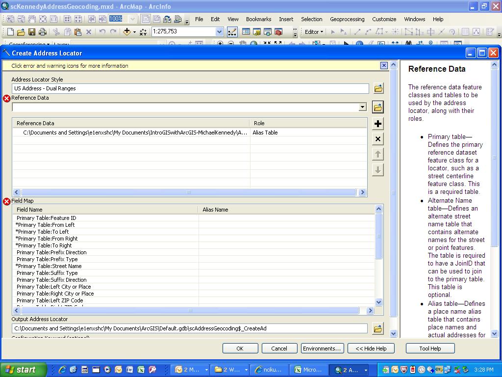
Then I used it as Reference Data to create an Address Locator and I got errors - see the attached files.
Please kindly help and advise me what is wrong in my xlsx file, what format I should use to create the table for Reference Data, and how to solve the errors.
Thanks,
Scott Chang
Hi all,
I used an Excel 2007 worksheet to make an xlsx file:
OID Org_Name Address City State ZIP_Code
0 Kentucky Theatre 214 East Main Street Lexington KY 40507
1 Repulic Bank & Trust Company 2401 Harrodsburg Road Lexington KY 40504
2 Square D 1601 Mercer Road Lexington KY 40501
3 Community Trust Bank 901 Beaumont Centre Parkway Lexington KY 40513
4 Link-Belt Cranes 2651 Palumbo Drive Lexington KY 40909
5 Central Bank & Trust Company 3270 Tates Creek Road Lexington KY 40509
6 Glass America 3801 Nicholasville Centre Drive Lexington KY 40503
7 Odessa Roofing Inc & Repair 232 Gold Rush Road Lexington KY 40503
8 Blue Grass Plating Co. 451 North Estill Avenue Richmond KY 40475
9 Farmers Bank 213 East Main Street Wilmore KY 40390
10 Central Bank & Trust Co. 301 North Main Street Nicholasville KY 40356
Then I used it as Reference Data to create an Address Locator and I got errors - see the attached files.
Please kindly help and advise me what is wrong in my xlsx file, what format I should use to create the table for Reference Data, and how to solve the errors.
Thanks,
Scott Chang
3 Replies
by
Anonymous User
Not applicable
04-18-2012
12:09 PM
- Mark as New
- Bookmark
- Subscribe
- Mute
- Subscribe to RSS Feed
- Permalink
04-19-2012
09:01 AM
- Mark as New
- Bookmark
- Subscribe
- Mute
- Subscribe to RSS Feed
- Permalink
Add one more jpg file to show the "$" is in the end of the xlsx name. Can the "$" cause the errors? When I try to create the Address Locator, how can I avoid using the "$" that came with the .xlsx file?
Scott,
Your reference data should be street centerlines, parcels, or some other type of data that has geometry and can be displayed on the map. Check the page below for some assistance in getting started. Also if you are only using one file as reference data it should be the primary table rather than alias table.
http://help.arcgis.com/en/arcgisdesktop/10.0/help/index.html#//002500000013000000.htm
M.O.
by
Anonymous User
Not applicable
04-19-2012
09:32 AM
- Mark as New
- Bookmark
- Subscribe
- Mute
- Subscribe to RSS Feed
- Permalink
Original User: jborgion
+1 to what Matt says.
The very basic concept of geocoding is you are matching a name or an address to a geographic location. For example: If I have a POINT feature class and three of the points are named Matts House, Joes House and Scotts House respectively, and I have a TABLE of events (like Loud Party Complaints) and those records contain various location references and a few show Joes House and a few more Show Matts house, I can then match those complaints to a geographic location, and display them in the form of a map.
Addtionally, if I have a LINE feature class of streets that have address ranges on them, I can use them as the basis to geo-locate my table of events. Lets say that Loud Party Compliant table has as locations not only references to Joes House and Matts House, but actual addresses as well; for example 1234 Main St.
I can create one locator based on points and one locator based on streets and composite them together. That way, regardless of how the location field in the complaints table is populated, 1234 Main St or Joes House, I will be able to get a match.
Bottom line: The G of GIS stands for Geography. You need to have a GIS feature class to match against. Your list of addresses you wish to map can be in just about any format you want. Spreadsheets included.
Hope this helps-