- Home
- :
- All Communities
- :
- Products
- :
- Data Management
- :
- Data Management Questions
- :
- Another Transformation Question NAD83 to WGS84 (Me...
- Subscribe to RSS Feed
- Mark Topic as New
- Mark Topic as Read
- Float this Topic for Current User
- Bookmark
- Subscribe
- Mute
- Printer Friendly Page
Another Transformation Question NAD83 to WGS84 (Melita K:HELP!)
- Mark as New
- Bookmark
- Subscribe
- Mute
- Subscribe to RSS Feed
- Permalink
A few days ago I posted Transformation from StatePlane NAD83 to WGS84 ; I ended up contacting tech support and they pointed me an on line doc that specifies which transformation option to use here in the lower 48.
My original confusion stemmed from a couple conversations with colleagues who just said: "I use the default when I project"
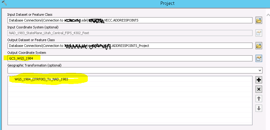
When you use the project tool, it does indeed provide a default transformation:

I read the default as wgs84 to nad83, not nad83 to wgs84.....
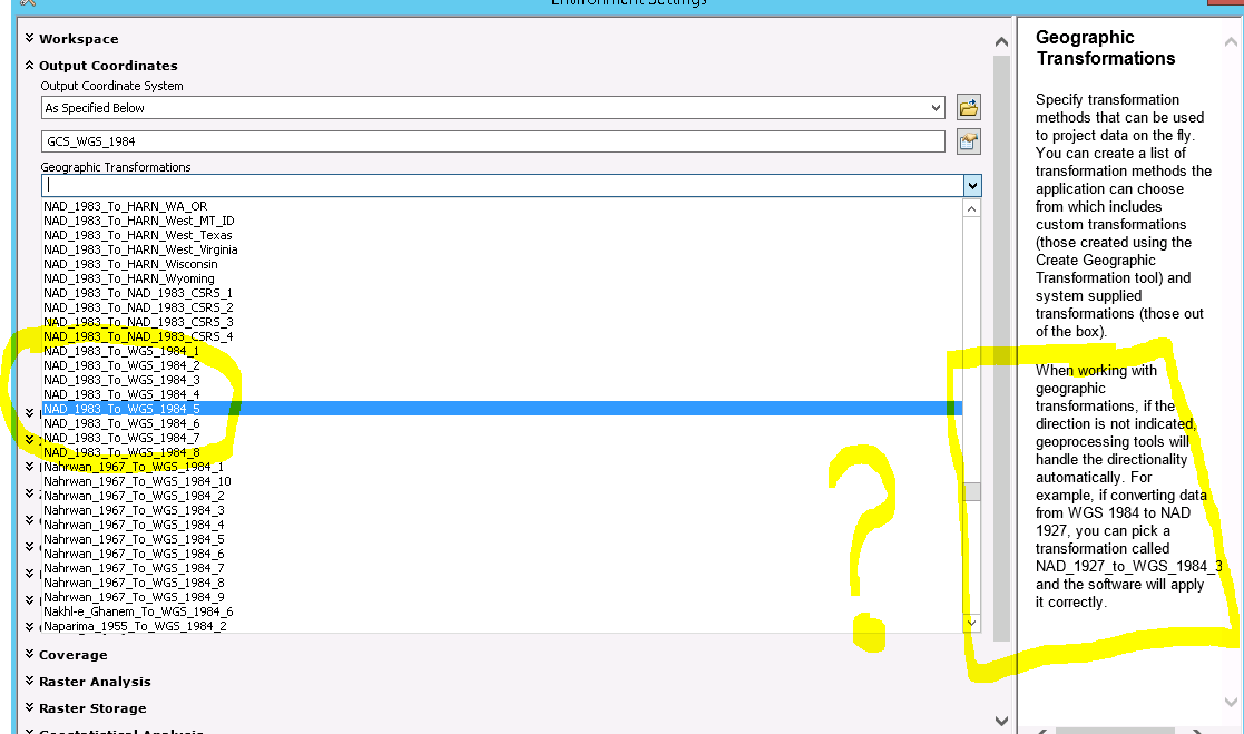
However, when you use a geoprocessing tool you can set your Output Coordinates Environment Setting. There is no default provided. I don't see the the one highlighted above in the pick list, only the ones mentioned in the tech paper sited in my earlier post:

So at this point I'm right back to my earlier confused state....
Solved! Go to Solution.
Accepted Solutions
- Mark as New
- Bookmark
- Subscribe
- Mute
- Subscribe to RSS Feed
- Permalink
The Project Tool is giving a 'best' choice or a sorted list based on the data's extents and the transformation extents and accuracies. The geoprocessing environment list doesn't have access to your area of interest so just gives a list sorted by names.
I usually try to define transformation in the same "order" that the source document uses. In this case, the WGS_1984_(ITRF00) one came from National Geodetic Survey CORS website. It's technically ITRF00 to NAD83 (CORS96 or HARN, more or less) and time-based, but we drop the time-based portion of the transformation.
Depending on your version, you may have more recent ones like an ITRF2008 to NAD83 (2011).
Melita
- Mark as New
- Bookmark
- Subscribe
- Mute
- Subscribe to RSS Feed
- Permalink
If you tag people in a post, then they should get an alert they have been tagged in content, since you are looking for Melita Kennedy on this particular question.
- Mark as New
- Bookmark
- Subscribe
- Mute
- Subscribe to RSS Feed
- Permalink
Although Melita will be able to answer any specifics better than I would even dream,
I read the default as wgs84 to nad83, not nad83 to wgs84.....
regarding this statement....the "to" actually goes both ways. that is it means both "wgs84 to nad83" AND "nad83 to wgs84".
You are not the only one that was confused by that the first time they saw it.
- Mark as New
- Bookmark
- Subscribe
- Mute
- Subscribe to RSS Feed
- Permalink
Rebecca...link here ... Geographic transformation methods—Help | ArcGIS for Desktop
- Mark as New
- Bookmark
- Subscribe
- Mute
- Subscribe to RSS Feed
- Permalink
Rebecca makes a good point on the reverse-ability of transformations. Here's what the ESRI help states:
Datum transformations work in either direction. For example, the transformation listed as NAD_1927_to_NAD_1983_NADCON transforms from NAD 1983 to NAD 1927, as well as from NAD 1927 to NAD 1983.
21327 - Select the correct geographic (datum) transformation when projecting between datums
Chris Donohue, GISP
- Mark as New
- Bookmark
- Subscribe
- Mute
- Subscribe to RSS Feed
- Permalink
I appreciate all the feed back- the confusion for me is in the lack of consistency between the projection tool and any other geoprocessing tool and what transformation method(s) is/are available.
For the last 25+ years, I've been using projected data for all my analyses. The trend now at least in the 9-1-1 industry where I work is migrating to GCS...
- Mark as New
- Bookmark
- Subscribe
- Mute
- Subscribe to RSS Feed
- Permalink
The Project Tool is giving a 'best' choice or a sorted list based on the data's extents and the transformation extents and accuracies. The geoprocessing environment list doesn't have access to your area of interest so just gives a list sorted by names.
I usually try to define transformation in the same "order" that the source document uses. In this case, the WGS_1984_(ITRF00) one came from National Geodetic Survey CORS website. It's technically ITRF00 to NAD83 (CORS96 or HARN, more or less) and time-based, but we drop the time-based portion of the transformation.
Depending on your version, you may have more recent ones like an ITRF2008 to NAD83 (2011).
Melita
- Mark as New
- Bookmark
- Subscribe
- Mute
- Subscribe to RSS Feed
- Permalink
Thanks Melita! That pretty much clears it up for me!
- Mark as New
- Bookmark
- Subscribe
- Mute
- Subscribe to RSS Feed
- Permalink
I'm glad to hear that, Joe! This stuff isn't getting simpler, it's getting more complicated now that we have better solutions and datum re-adjustments. ![]()