- Home
- :
- All Communities
- :
- Products
- :
- Data Management
- :
- Data Management Blog
- :
- Options To Pull Geographic Coordinates From A Geom...
Options To Pull Geographic Coordinates From A Geometry Store
- Subscribe to RSS Feed
- Mark as New
- Mark as Read
- Bookmark
- Subscribe
- Printer Friendly Page
Ran into something interesting that might be worth sharing with the group. One of the developers on staff ran into an issue where he couldn't pull lat/long from the database because the shape fields are stored as Geometry (not geography) and we didn't store Lat/Long within the tables. For those who weren't aware you can put a SQL query in to generate X,Y for you from the shape fields present in our databases. The syntax will be a bit different based on database version (not SDE version). For MS SQL coming out of a Geometry Column you would use something like Example 1.
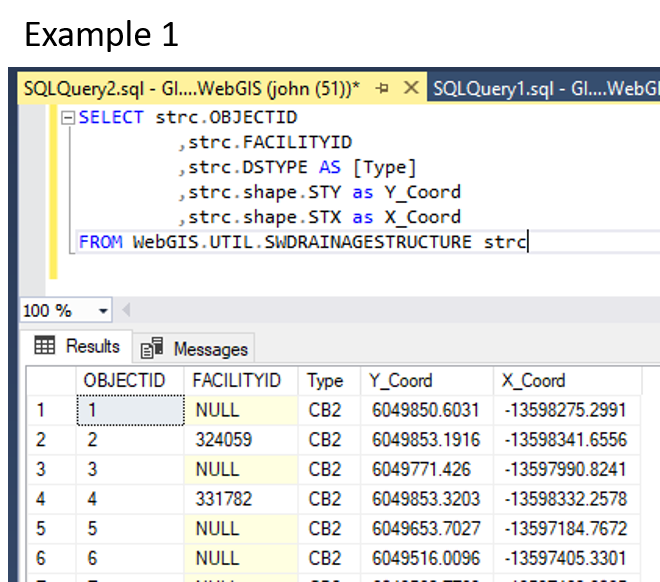
So how do you pull that information out for an application to use/reference? Here is what I came up with for him.
Option 1 Using Arcade:
For those using ArcGIS Pro and/or ArcGIS Online, a increasingly useful capability would be to use the Arcade scripting language. In this case, build a function. As a proof of concept, I looped it into a URL could be easily parsed via Google Maps. They can change the URL to match a Collector, Survey 123, or other application at will. See examples 2A and 2B(accidently labeled again 2A to keep everyone on their toes).


Option 2 Using SQL:
With ArcGIS you can create query layers, but when published via ArcGIS Server, which this developer was doing, there is a performance hit to the server each time it pulls one of these query layers. Sure it is more of a pain, but your Database Administrator can create and adjust views just as fast and they put the burden of rendering on the database server which usually has capacity to spare. That said, you can add columns in queries and even do math along the way. See Example 3. Keep in mind the syntax of Example 3 is for MS SQL. As most of you are using Oracle, it may be slightly different for some of the operators like PI, though that is a bad example as PI is called the same way in Oracle. The moral of the story though is double check that all the operators (functions) are correct.
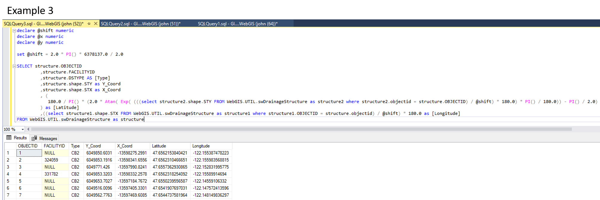
declare @shift numeric
declare @x numeric
declare @y numericset @shift = 2.0 * PI() * 6378137.0 / 2.0
SELECT structure.OBJECTID
,structure.FACILITYID
,structure.DSTYPE AS [Type]
,structure.shape.STY as Y_Coord
,structure.shape.STX as X_Coord
, (
180.0 / PI() * (2.0 * Atan( Exp( (((select structure2.shape.STY FROM WebGIS.UTIL.swDrainageStructure as structure2 where structure2.objectid = structure.OBJECTID) / @shift) * 180.0) * PI() / 180.0)) - PI() / 2.0)
) as [Latitude]
,((select structure1.shape.STX FROM WebGIS.UTIL.swDrainageStructure as structure1 where structure1.OBJECTID = structure.objectid) / @shift) * 180.0 as [Longitude]
FROM WebGIS.UTIL.swDrainageStructure as structure
You must be a registered user to add a comment. If you've already registered, sign in. Otherwise, register and sign in.